Maps of Domanín

Domanín o. Jindřichův Hradec 1
1 : 2880
Domanín o. Jindřichův Hradec 1
1 : 2880
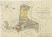
Geometrický plán dvora Obora s přilehlými pozemky a rybníky v polesí Zámecký

Hospodářská mapa pozemků dvora Obora 1
1 : 2880
Branná o. Jindřichův Hradec 1
1 : 2880
Mapa pozemků dvora Obora v tzv. Velkém doubí 1

Situační plán nové studně a plotu u zahrady pro zaměstnance při dvoře Obora 1

Hospodářská mapa dvora Vrchy 1

Plán pozemků dvora Vrchy 1
Třeboň o. Jindřichův Hradec 1
1 : 2880
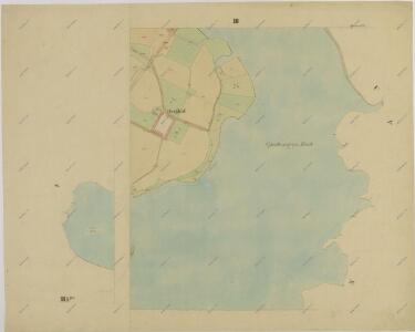
Branna - c0470-1-006 - Kaiserpflichtexemplar der Landkarten des stabilen Katasters
1 : 2880
Branna - c0470-1-003 - Kaiserpflichtexemplar der Landkarten des stabilen Katasters
1 : 2880
Branna - c0470-1-007 - Kaiserpflichtexemplar der Landkarten des stabilen Katasters
1 : 2880
Branna - c0470-1-008 - Kaiserpflichtexemplar der Landkarten des stabilen Katasters
1 : 2880
Branna - c0470-1-009 - Kaiserpflichtexemplar der Landkarten des stabilen Katasters
1 : 2880
Branna - c0470-1-004 - Kaiserpflichtexemplar der Landkarten des stabilen Katasters
1 : 2880
Branna - c0470-1-002 - Kaiserpflichtexemplar der Landkarten des stabilen Katasters
1 : 2880
Branna - c0470-1-005 - Kaiserpflichtexemplar der Landkarten des stabilen Katasters
1 : 2880
Branna - c0470-1-001 - Kaiserpflichtexemplar der Landkarten des stabilen Katasters
1 : 2880
Domanin - c1424-1-006 - Kaiserpflichtexemplar der Landkarten des stabilen Katasters
1 : 2880
Domanin - c1424-1-007 - Kaiserpflichtexemplar der Landkarten des stabilen Katasters
1 : 2880
Domanin - c1424-1-002 - Kaiserpflichtexemplar der Landkarten des stabilen Katasters
1 : 2880
Domanin - c1424-1-001 - Kaiserpflichtexemplar der Landkarten des stabilen Katasters
1 : 2880
Domanin - c1424-1-004 - Kaiserpflichtexemplar der Landkarten des stabilen Katasters
1 : 2880
Domanin - c1424-1-003 - Kaiserpflichtexemplar der Landkarten des stabilen Katasters
1 : 2880
Domanin - c1424-1-005 - Kaiserpflichtexemplar der Landkarten des stabilen Katasters
1 : 2880
Geometrický plán rybníka Svět s přilehlými pozemky
Geometrický plán města Třeboně s předměstím, Novým Dvorem a přilehlými pozemky

Hospodářská mapa pozemků dvora Obora 1