Maps of Planá
Katastrální mapa obce Kříženec
1 : 2880
Hospodářská mapa revíru Michalovy Hory-Catlov-Otín
1 : 8640
Kiesenrieth - c3667-1-003 - Kaiserpflichtexemplar der Landkarten des stabilen Katasters
1 : 2880
Kiesenrieth - c3667-1-001 - Kaiserpflichtexemplar der Landkarten des stabilen Katasters
1 : 2880
Kiesenrieth - c3667-1-002 - Kaiserpflichtexemplar der Landkarten des stabilen Katasters
1 : 2880
Kiesenrieth - c3667-1-004 - Kaiserpflichtexemplar der Landkarten des stabilen Katasters
1 : 2880
Hospodářská mapa revíru Caltov
1 : 8640
Ottenreuth - c5588-1-003 - Kaiserpflichtexemplar der Landkarten des stabilen Katasters
1 : 2880
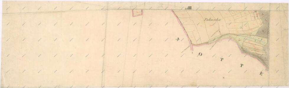
Ottenreuth - c5588-1-001 - Kaiserpflichtexemplar der Landkarten des stabilen Katasters
1 : 2880
Ottenreuth - c5588-1-002 - Kaiserpflichtexemplar der Landkarten des stabilen Katasters
1 : 2880
Plán pozemků dvora Catlov
1 : 14500
Katastrální mapa obce Planá
1 : 2880
Přehledná mapa panství Planá
1 : 25000
[Kartenblatt]
1 : 25000 Planá (Tachov, Česko : oblast) Reichsamt für Landesaufnahme
III. vojenské mapování 4049/4
1 : 25000
Gradkartenblatt
1 : 25000 Tachov-oblast (Česko) Bulla, Eduard
Hospodářská mapa revíru Kočov
1 : 4350
Rundansicht von dem Basaltberge Podhorn (2634 Wien. Fuss) auf der Herrschaft Tepl bei Marienbad
Mariánské Lázně-oblast (Česko) Frey, Paul
Rundansicht von dem Basaltberge Podhorn (833 Meter) auf der Herrschaft Tepl bei Marienbad
Mariánské Lázně-oblast (Česko) F.A. Götz
Umgebungskarte der Curstadt Marienbad
1 : 60000 Mariánské Lázně-oblast (Česko) E.A. Götz
Umgebungskarte der Kurstadt Marienbad
1 : 50000 Mariánské Lázně-oblast (Česko) E.A. Götz
Hayder Vicariat
Bor-oblast (Tachov, Česko)
Marienbad und Tachau
1 : 75000 Mariánské Lázně (Česko : oblast) Höller, K. K. u. k. Militärgeographisches Institut
Marienbad und Tachau
1 : 75000 Mariánské Lázně (Česko : oblast) K. u. k. Militärgeographisches Institut
Stříbro a okolí
1 : 75000 Stříbro (Česko : oblast) Vojenský zeměpisný ústav
Mariánské Lázně
1 : 75000 Chodová Planá (Česko : oblast) Vojenský zeměpisný ústav
Mariánské Lázně
1 : 75000 Mariánské Lázně (Česko : oblast) Vojenský zeměpisný ústav
Mariánské Lázně
1 : 75000 Mariánské Lázně-oblast (Česko) Vojenský zeměpisný ústav
III. vojenské mapování 4049
1 : 75000