Maps of Planá

Hospodářská mapa revíru Kočov
1 : 4350

Gradkartenblatt
1 : 25000 Tachov-oblast (Česko) Bulla, Eduard
[Kartenblatt]
1 : 25000 Planá (Tachov, Česko : oblast) Reichsamt für Landesaufnahme
III. vojenské mapování 4049/4
1 : 25000
Přehledná mapa panství Planá
1 : 25000
Hospodářská mapa revíru Kočov
1 : 11520
Plan - c5801-1-008 - Kaiserpflichtexemplar der Landkarten des stabilen Katasters
1 : 2880
Plan - c5801-1-007 - Kaiserpflichtexemplar der Landkarten des stabilen Katasters
1 : 2880
Plan - c5801-1-004 - Kaiserpflichtexemplar der Landkarten des stabilen Katasters
1 : 2880
Plan - c5801-1-002 - Kaiserpflichtexemplar der Landkarten des stabilen Katasters
1 : 2880
Plan - c5801-1-005 - Kaiserpflichtexemplar der Landkarten des stabilen Katasters
1 : 2880
Plan - c5801-1-006 - Kaiserpflichtexemplar der Landkarten des stabilen Katasters
1 : 2880
Plan - c5801-1-003 - Kaiserpflichtexemplar der Landkarten des stabilen Katasters
1 : 2880
Plan - c5801-1-001 - Kaiserpflichtexemplar der Landkarten des stabilen Katasters
1 : 2880
Entwurff der freyherrl. Haimhausischen Herrshafft Kuttenplan wie solche anno 1676 in Esse sich befunden
Chodová Planá-oblast (Česko)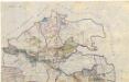
Přehledová mapa velkostatku Tachov
1 : 17280
Přehledová mapa velkostatku Tachov
1 : 17280
Situační plán pro hon v Trnové
1 : 25857
Kuttenplan - c2556-1-006 - Kaiserpflichtexemplar der Landkarten des stabilen Katasters
1 : 2880
Kuttenplan - c2556-1-007 - Kaiserpflichtexemplar der Landkarten des stabilen Katasters
1 : 2880
Kuttenplan - c2556-1-003 - Kaiserpflichtexemplar der Landkarten des stabilen Katasters
1 : 2880
Kuttenplan - c2556-1-001 - Kaiserpflichtexemplar der Landkarten des stabilen Katasters
1 : 2880
Kuttenplan - c2556-1-005 - Kaiserpflichtexemplar der Landkarten des stabilen Katasters
1 : 2880
Kuttenplan - c2556-1-002 - Kaiserpflichtexemplar der Landkarten des stabilen Katasters
1 : 2880
Kuttenplan - c2556-1-004 - Kaiserpflichtexemplar der Landkarten des stabilen Katasters
1 : 2880
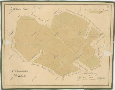
Gottschau - c3243-1-003 - Kaiserpflichtexemplar der Landkarten des stabilen Katasters
1 : 2880
Gottschau - c3243-1-001 - Kaiserpflichtexemplar der Landkarten des stabilen Katasters
1 : 2880
Gottschau - c3243-1-004 - Kaiserpflichtexemplar der Landkarten des stabilen Katasters
1 : 2880
Gottschau - c3243-1-002 - Kaiserpflichtexemplar der Landkarten des stabilen Katasters
1 : 2880
Gottschau - c3243-1-005 - Kaiserpflichtexemplar der Landkarten des stabilen Katasters
1 : 2880