Maps of Temnitztal

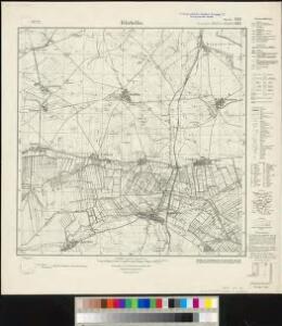
Messtischblatt 1619, neue Nr. 3142 : Fehrbellin, 1936 Fehrbellin
1 : 250000 Fehrbellin. - Hrsg. 1882, einz. Nachtr. 1926, gedr. [19]36. - 1:25000. - [Berlin]: Reichsamt für Landesaufnahme, 1936. - 1 Kt.
Meßtischblatt 1619 : Fehrbellin, 1911
1 : 250000 Fehrbellin. - Aufn. 1880, hrsg. 1882, einz. Nachtr. 1911. - 1:25000. - [Berlin]: Reichsamt für Landesaufnahme, 1911. - 1 Kt.
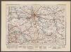
242. Neu-Ruppin.
1 : 100000 Reichsamt fur Landesaufnahme
Composite: 242. Neu-Ruppin.
1 : 100000 Reichsamt fur Landesaufnahme
76. Charlottenburg, uit: Topographische Uebersichtskarte des Deutschen Reiches / herausgegeben v. d. Kartogr. Abt. d. Königl. Preuß. Landesaufnahme
1 : 200000 titelvariant: Topogr. Übersichtskarte des Deutschen Reiches; Annotatie: Titel boven bladen ook: Topogr. Übersichtskarte des Deutschen Reiches; Annotatie geografische gegevens: Op elk blad twee maatstokken: 10 Kilometer = 5,5 cm; 1 geogr. Meile = 3,6 cm; Legenda onder op elk blad Königlich Preußische Landesaufnahme. Kartographische Abtheilung [S.l : Königlich Preußische Landesaufnahme, Kartographische Abtheilung]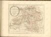

Ruppin 47, uit: Special-Karte von Mittel-Europa / nach amtlichen Quellen bearbeitet von W. Liebenow
1 : 300000 titelvariant: W. Liebenow's Mittel-Europa; Annotatie: Titel boven de bladen: W. Liebenow's Mittel-Europa Johannes Wilhelm Liebenow 1822-1897 Frankfurt a. M. : Ludwig Ravenstein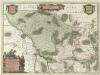
Marchionatvs Brandenburgici
1 : 330000 Mollova mapová sbírka Örnehufvud, Olof Hansson Covens, Johannes I
MARCHIONATUS | BRANDENBURGICI | PARTES DUÆ, | RUPPIN | Comitatus | & | PRIGNITS | Regiuncula
Auct. Olao Iohannis Gotho, Gustavo Magno Cosm. [Amsterdam : Joan Blaeu]
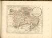
MARCH. BRANDENBURGICI | PARS, quæ | MARCHIA MEDIA | Vulgo MITTELMARCK audit.
Amstelædami, | Excud. Joannes Blaeu.
[Berlin und Umgebung; Die Donau von Paussau bis Wien mit Umgebung]
Stieler's Hand-Atlas Stieler, Adolf bei Justus Perthes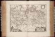
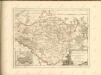
March. Brandenburgici pars, quae Marchia Media vulgo Mittelmarck audit
1 : 400000 Annotatie: Origineel is Blad 91 in atlas factice; Annotatie geografische gegevens: Met schaalstok: Milliaria Germanica Joan Blaeu 1597/98-1673 Amstelaedami : excud. Joannes Blaeu
Berlin - Leipzig - Wittenberge

[Operationen der alliirten und französischen Armee 1759]

Sect. 8: Schwerin, uit: Geologische Karte des Deutschen Reichs in 27 Blaettern / [von] Richard Lepsius ; Red. von C. Vogel
1 : 500000 Annotatie: Blad 18 ontbreekt; Een aantal bladen op linnen; Een aantal bladen gereviseerd 1913-1914; Annotatie geografische gegevens: Met schaalstokken o.a. in kilometers; Legenda Carl Vogel 1828-1897 Gotha : Justus Perthes
Saxoniae Tractus Ducatum Magdeburgensem
1 : 370000 Mollova mapová sbírka Homann, Johann Baptist Homann, Johann Baptista
Saxoniae tractus Ducatum Magdeburgensem cum suo circulo Salico princ. Anhaltinum Halberstadiensem finitimarumq. regionum electoratus nempe Brandenburg. Saxoniae ducatus Brunsvicensis etc. partes ostendens
1 : 490000 Anhaltsko (Německo) Homann, Johann Christoph Homannovi dědicové
Saxoniae tractus ducatum Magdeburgensem cum suo circulo Salico princ. Anhaltinum Halberstadiensem finitimarumq. regionum electoratus nempe Brandenburg. Saxoniae ducatus Brunsvicensis etc. partes ostendens
1 : 490000 Anhaltsko (Německo) Homann, Johann Christoph Homannovi dědicové
Marchia Media Vulgo Mittel Marck in March: Brandenb:
1 : 500000 Mollova mapová sbírka Valk, Gerhard Schenk, Peter I
Marchia Media Vulgo Mittel Marck in March: Brandenb:
1 : 510000 Mollova mapová sbírka Janssonius, Johannes Janssonius, Johannes I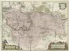
March. Brandenburgici Pars, quae Marchia Media Vulgo Mittesmarck audit
1 : 400000 Mollova mapová sbírka Wit, Frederik de Covens, Johannes I
Straßen in den Mecklenburgischen Herzogtümern 1848 (Auswahl)
Mecklenburg Straßennetz Kunz, Andreas ; Treiling, Thomas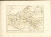
Berlin
1 : 600000 Opitz, Carl Solbrig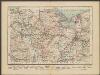
Stettin
1 : 600000 Opitz, Carl Solbrig
Marchia Media; Vulgo Mittel Marck in March: Brandenb: [Karte], in: Novus atlas absolutissimus, Bd. 2, S. 60.
1 Karte aus Atlas Janssonius Offizin
Brandebvrgvm Marchionatvs cum Ducatibus Pomeraniae et Mekelenbvrgi
1 : 1100000 Mollova mapová sbírka Merian, Matthäus Merian, Matthäus - dědici