Maps of Havelland

76. Charlottenburg, uit: Topographische Uebersichtskarte des Deutschen Reiches / herausgegeben v. d. Kartogr. Abt. d. Königl. Preuß. Landesaufnahme
1 : 200000 titelvariant: Topogr. Übersichtskarte des Deutschen Reiches; Annotatie: Titel boven bladen ook: Topogr. Übersichtskarte des Deutschen Reiches; Annotatie geografische gegevens: Op elk blad twee maatstokken: 10 Kilometer = 5,5 cm; 1 geogr. Meile = 3,6 cm; Legenda onder op elk blad Königlich Preußische Landesaufnahme. Kartographische Abtheilung [S.l : Königlich Preußische Landesaufnahme, Kartographische Abtheilung]
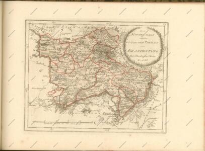
Le cercle de Glien et de Loewenberg dans la Marche-Moyenne de Brandenbourg
1 : 296000 Braniborsko (Německo) Oesfeld, Karl Ludwig von
Composite: 292. Brandenburg a. d. Havel
1 : 100000 Reichsamt fur Landesaufnahme
293. Potsdam.
1 : 100000 Reichsamt fur Landesaufnahme
292. Brandenburg a. d. Havel
1 : 100000 Reichsamt fur Landesaufnahme
Composite: 293. Potsdam.
1 : 100000 Reichsamt fur Landesaufnahme
267. Rathenow.
1 : 100000 Reichsamt fur Landesaufnahme
Composite: 268. Spandau.
1 : 100000 Reichsamt fur Landesaufnahme
Composite: 267. Rathenow.
1 : 100000 Reichsamt fur Landesaufnahme
268. Spandau.
1 : 100000 Reichsamt fur Landesaufnahme
Blatt V Potsdam, uit: Karte von Berlin und Umgebung in 12 Blättern
1 : 50000 Annotatie: Toelichtingen opgeborgen bij kaart; Annotatie geografische gegevens: Met schaalstokken: Meter, Schritt, geographische Meile Paul Schneider Berlin : Reichsamt für Landesaufnahme
Blatt I Nauen, uit: Karte von Berlin und Umgebung in 12 Blättern
1 : 50000 Annotatie: Toelichtingen opgeborgen bij kaart; Annotatie geografische gegevens: Met schaalstokken: Meter, Schritt, geographische Meile Paul Schneider Berlin : Reichsamt für Landesaufnahme
Blatt IX Werder, uit: Karte von Berlin und Umgebung in 12 Blättern
1 : 50000 Annotatie: Toelichtingen opgeborgen bij kaart; Annotatie geografische gegevens: Met schaalstokken: Meter, Schritt, geographische Meile Paul Schneider Berlin : Reichsamt für Landesaufnahme
242. Neu-Ruppin.
1 : 100000 Reichsamt fur Landesaufnahme
Composite: 243. Oranienburg.
1 : 100000 Reichsamt fur Landesaufnahme
243. Oranienburg.
1 : 100000 Reichsamt fur Landesaufnahme
Composite: 242. Neu-Ruppin.
1 : 100000 Reichsamt fur Landesaufnahme

Gegend zwischen Spandau und Nauen
1 : 160000 Špandava (Berlín, Německo)
Umgegend von Potsdam
1 : 66666 gez[eichnet] v. L. Kraatz [...] Berlin : Reimer
Meßtischblatt 3644 : Potsdam, 1942
1 : 250000 Potsdam. - Aufn. 1901, hrsg. 1903, bericht. 1919, letzte Nachtr. 1940. - 1:25000. - [Berlin]: Reichsamt für Landesaufnahme, 1942. - 1 Kt.
Meßtischblatt 1974 : Potsdam (Süd), 1936
1 : 250000 Potsdam (Süd). - Hrsg. 1903, bericht. 1919, einz. Nachtr. 1936. - 1:25000. - [Berlin]: Reichsamt für Landesaufnahme, 1936. - 1 Kt.
Meßtischblatt 3643 : Werder, 1941
1 : 250000 Werder. - Aufn. 1901, hrsg. 1903, bericht. 1919, letzte Nachtr. 1940. - 1:25000. - [Berlin]: Reichsamt für Landesaufnahme, 1941. - 1 Kt.
Meßtischblatt 1973/1974 (Doppelblatt) : Werder/Potsdam-Süd, 1912
1 : 250000 Werder/Potsdam (Süd). - Aufn. 1901, hrsg. 1903, bericht. 1906, einz. Nachtr. 1912. - 1:25000. - [Berlin]: Reichsamt für Landesaufnahme, 1912. - 1 Kt.
Meßtischblatt 3642 : Lehnin, 1955
1 : 250000 Lehnin. - Hrsg. 1882, bericht. 1940, Ausg. 1942. - 1:25000. - [Berlin]: MdI, 1955. - 1 Kt.
Meßtischblatt 1972 : Lehnin, 1916
1 : 250000 Lehnin. - Aufn. 1880, hrsg. 1882, Aufldr. 1916. - 1:25000. - [Berlin]: Reichsamt für Landesaufnahme, 1916. - 1 Kt.
Meßtischblatt 3641 : Göttin, 1942
1 : 250000 Göttin. - Aufn. 1882, hrsg. 1883, bericht. 1940. - 1:25000. - [Berlin]: Reichsamt für Landesaufnahme, 1942. - 1 Kt.
Meßtischblatt [1971] : Göttin, 1922
1 : 250000 Göttin. - Aufn. 1882, Nachtr. 1922. - 1:25000. - [Berlin]: Reichsamt für Landesaufnahme, 1922. - 1 Kt.