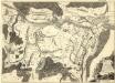
Maps of Potsdam-Mittelmark

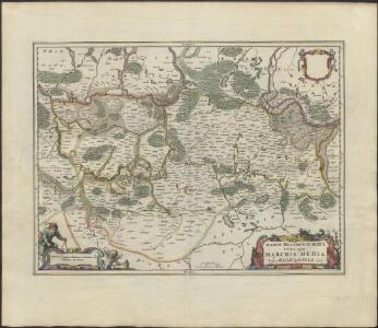
MARCH. BRANDENBURGICI | PARS, quæ | MARCHIA MEDIA | Vulgo MITTELMARCK audit.
Amstelædami, | Excud. Joannes Blaeu.
March. Brandenburgici pars, quae Marchia Media vulgo Mittelmarck audit
1 : 400000 Annotatie: Origineel is Blad 91 in atlas factice; Annotatie geografische gegevens: Met schaalstok: Milliaria Germanica Joan Blaeu 1597/98-1673 Amstelaedami : excud. Joannes Blaeu
[Berlin und Umgebung; Die Donau von Paussau bis Wien mit Umgebung]
Stieler's Hand-Atlas Stieler, Adolf bei Justus Perthes
Berlin 60, uit: Special-Karte von Mittel-Europa / nach amtlichen Quellen bearbeitet von W. Liebenow
1 : 300000 titelvariant: W. Liebenow's Mittel-Europa; Annotatie: Titel boven de bladen: W. Liebenow's Mittel-Europa Johannes Wilhelm Liebenow 1822-1897 Frankfurt a. M. : Ludwig Ravenstein

Topographische Carte : Hundert Quadrat-Meilen um Berlin
1 : 184000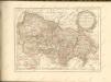

Ruppin 47, uit: Special-Karte von Mittel-Europa / nach amtlichen Quellen bearbeitet von W. Liebenow
1 : 300000 titelvariant: W. Liebenow's Mittel-Europa; Annotatie: Titel boven de bladen: W. Liebenow's Mittel-Europa Johannes Wilhelm Liebenow 1822-1897 Frankfurt a. M. : Ludwig Ravenstein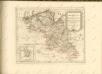

89. Potsdam, uit: Topographische Uebersichtskarte des Deutschen Reiches / herausgegeben v. d. Kartogr. Abt. d. Königl. Preuß. Landesaufnahme
1 : 200000 titelvariant: Topogr. Übersichtskarte des Deutschen Reiches; Annotatie: Titel boven bladen ook: Topogr. Übersichtskarte des Deutschen Reiches; Annotatie geografische gegevens: Op elk blad twee maatstokken: 10 Kilometer = 5,5 cm; 1 geogr. Meile = 3,6 cm; Legenda onder op elk blad Königlich Preußische Landesaufnahme. Kartographische Abtheilung [S.l : Königlich Preußische Landesaufnahme, Kartographische Abtheilung]
Der Lebusische Creis
1 : 296000 Lubušsko (Německo a Polsko) Oesfeld, Karl Ludwig von Sotzmann, Daniel Friedrich
Der Lebusische Creis
1 : 296000 Lubušsko (Německo a Polsko) Oesfeld, Karl Ludwig von Sotzmann, Daniel Friedrich
Der Lebusische Creis
1 : 296000 Lubušsko (Německo a Polsko) Oesfeld, Karl Ludwig von Sotzmann, Daniel Friedrich
Geologische Übersichtskarte der Umgegend von Berlin
1 : 100000 Berendt, G. ; Laufer, E. Lithogr. Institut
76. Charlottenburg, uit: Topographische Uebersichtskarte des Deutschen Reiches / herausgegeben v. d. Kartogr. Abt. d. Königl. Preuß. Landesaufnahme
1 : 200000 titelvariant: Topogr. Übersichtskarte des Deutschen Reiches; Annotatie: Titel boven bladen ook: Topogr. Übersichtskarte des Deutschen Reiches; Annotatie geografische gegevens: Op elk blad twee maatstokken: 10 Kilometer = 5,5 cm; 1 geogr. Meile = 3,6 cm; Legenda onder op elk blad Königlich Preußische Landesaufnahme. Kartographische Abtheilung [S.l : Königlich Preußische Landesaufnahme, Kartographische Abtheilung]
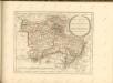
Der Ober Barnimsche Creis
1 : 292000 Braniborsko (Německo) Oesfeld, Karl Ludwig von Jättnig, Karl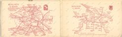
Taschenplan von Berlin

90. Berlin (Süd), uit: Topographische Uebersichtskarte des Deutschen Reiches / herausgegeben v. d. Kartogr. Abt. d. Königl. Preuß. Landesaufnahme
1 : 200000 titelvariant: Topogr. Übersichtskarte des Deutschen Reiches; Annotatie: Titel boven bladen ook: Topogr. Übersichtskarte des Deutschen Reiches; Annotatie geografische gegevens: Op elk blad twee maatstokken: 10 Kilometer = 5,5 cm; 1 geogr. Meile = 3,6 cm; Legenda onder op elk blad Königlich Preußische Landesaufnahme. Kartographische Abtheilung [S.l : Königlich Preußische Landesaufnahme, Kartographische Abtheilung]
77. Berlin (Nord), uit: Topographische Uebersichtskarte des Deutschen Reiches / herausgegeben v. d. Kartogr. Abt. d. Königl. Preuß. Landesaufnahme
1 : 200000 titelvariant: Topogr. Übersichtskarte des Deutschen Reiches; Annotatie: Titel boven bladen ook: Topogr. Übersichtskarte des Deutschen Reiches; Annotatie geografische gegevens: Op elk blad twee maatstokken: 10 Kilometer = 5,5 cm; 1 geogr. Meile = 3,6 cm; Legenda onder op elk blad Königlich Preußische Landesaufnahme. Kartographische Abtheilung [S.l : Königlich Preußische Landesaufnahme, Kartographische Abtheilung]
Karte der Berlin-Anhaltischen Eisenbahn
1 : 200000 Verlag von Simon Schropp & Cop.
Der Teltowische Creis
1 : 300000 Oesfeld, Karl Ludwig von Jättnig, Karl
Der Nieder-Barnimsche Creis
1 : 302000 Braniborsko (Německo) Oesfeld, Karl Ludwig von Glassbach, Carl Christian
Richtiger geograph. Entwurff des zu dem Saechs. Chur. Creisse gehörigen Ammtes Beltzig
1 : 125000 Braniborsko (Německo) Schenk, Pieter bey Petrus Schenk
86. Berlin, Districts of Leipzig, Dresden, Karl-Marx-Stadt. The World Atlas.
1 : 1250000 USSR (Union of Soviet Socialist Republics).
Berlin unter alliierter Verwaltung 1.9.1945
Berlin Kunz, Andreas ; Moeschl, Joachim Robert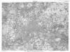
Berlin (1944)
Germany. Berlin. Scale, 1: 59,000 (approx.). Copied from a German map dated 1931. G.S.G.S. (Misc.) No.168. [London] : War Office
Le cercle de Glien et de Loewenberg dans la Marche-Moyenne de Brandenbourg
1 : 296000 Braniborsko (Německo) Oesfeld, Karl Ludwig von
Praefecturae principatus querfurtensis Dahmiana et Iüterboccensis cum vicinia oppidis, vicis, pagis accurate distincta
1 : 130000 Braniborsko (Německo) Seutter, Matthäus Lotter, Tobias Conrad M. Seutter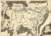
Exacter und accurater Plan der Manoeuvres, so dans König. Preuss. Corps, währender Zeit, dass selbiges zwischen der Stadt Spandau, und dem Dorfe Gatow campiret, täglich vorgenommen
1 : 15000 Mollova mapová sbírka Schleuen, Johann David Voss, Christian Friedrich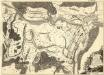
Exacter und accurater Plan der Manoeuvres, so dans König. Preuss. Corps, währender Zeit, dass selbiges zwischen der Stadt Spandau, und dem Dorfe Gatow campiret, täglich vorgenommen
1 : 15000 Mollova mapová sbírka Schleuen, Johann David Voss, Christian Friedrich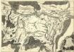
Exacter und accurater Plan der Manoeuvres, so dans König. Preuss. Corps, währender Zeit, dass selbiges zwischen der Stadt Spandau, und dem Dorfe Gatow campiret, täglich vorgenommen
1 : 15000 Mollova mapová sbírka Schleuen, Johann David Voss, Christian Friedrich