Maps of gmina Reńska Wieś

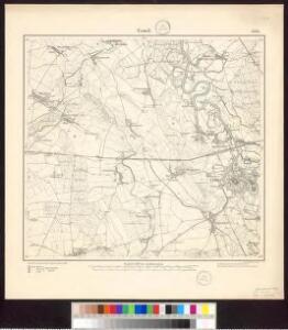
Meßtischblatt 3304 : Cosel, 1883
1 : 250000 Cosel. - Aufn. 1882, hrsg. 1883. - 1:25000. - [Berlin]: Kgl. Preuss. Landesaufnahme, 1883. - 1 Kt.
Cosel
1 : 75000 Ministerstvo národní obrany
146. Ratibor, uit: Topographische Uebersichtskarte des Deutschen Reiches / herausgegeben v. d. Kartogr. Abt. d. Königl. Preuß. Landesaufnahme
1 : 200000 titelvariant: Topogr. Übersichtskarte des Deutschen Reiches; Annotatie: Titel boven bladen ook: Topogr. Übersichtskarte des Deutschen Reiches; Annotatie geografische gegevens: Op elk blad twee maatstokken: 10 Kilometer = 5,5 cm; 1 geogr. Meile = 3,6 cm; Legenda onder op elk blad Königlich Preußische Landesaufnahme. Kartographische Abtheilung [S.l : Königlich Preußische Landesaufnahme, Kartographische Abtheilung]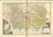

Přehledná mapa panství biskupství Vratislavského v Československé republice podle stavu ke dni 1. ledna 1929
1 : 75000 Vratislav-oblast (Polsko) Bauer, E. Vojenský zeměpisný ústav
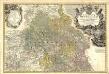
Das Fürstenthum Oppeln in Ober Schlesien
Mollova mapová sbírka Schleuen, Johann David Schleuen, Johann David
Sbírka map a diagramů použitých na mírových konferencích v Paříži v letech 1919 - 1920

Das Fürstenthum Oppeln in Ober Schlesien
1 : 720000 Horní Slezsko Schleuen, Johann David I.D. Schleuen
Carte ethnographique de la région de Ratiboř
Ratiboř (Polsko : oblast) Service cartographique de l'Armée Tchécoslovaque
[Die Markgraftschaft Mähren]
1 : 200000 Opava-oblast (Česko) Schenkl, Conrad Philipp Carl Winiker
Der Troppauer Kreis
1 : 200000 Jeseníky (Česko) Schenkl, Conrad Philipp Carl Winiker

Neisse 91, uit: Special-Karte von Mittel-Europa / nach amtlichen Quellen bearbeitet von W. Liebenow
1 : 300000 titelvariant: W. Liebenow's Mittel-Europa; Annotatie: Titel boven de bladen: W. Liebenow's Mittel-Europa Johannes Wilhelm Liebenow 1822-1897 Frankfurt a. M. : Ludwig Ravenstein
Troppauer Kreis

Die Markgrafschaft Maehren mit dem Herzogthume Schlesien
Principatvs Silesiae Oppoloniensis exactissima Tabula geographica, sistens Circvlos Oppoloniensem Ober-Glogav Gros Strehliz, Cosel, Tost, Rosenberg, Falckenberg & Lvblenitz.
1 : 216000 Mollova mapová sbírka Wieland, Johann Wolfgang Homann, Johann Baptista - dědici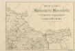
Mapa silnic Markrabství Moravského s enklávou Osoblažskou ve Vejvodství Slezském

Reisekarte durch die Mähr.-Schles.-Sudeten
1 : 200000 Jeseníky (Česko : pohoří) A. Blažek
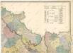
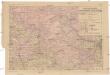
Geognostische Karte von Ober-Schlesien
1 : 200000 Dolnoslezské vojvodství (Polsko) Carnall, Rudolph von Simmon Schropp & co.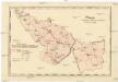
Mapa dekanátů, poutních míst a klášterů vévodství slezského
Slezsko (Česko)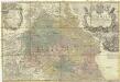
Principatvs Silesiae Oppoliensis
1 : 218000 Opolsko (Polsko) Wieland, Johann Wolfgang Homannianis Heredibus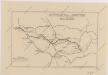
Sbírka map a diagramů použitých na mírových konferencích v Paříži v letech 1919 - 1920

Die Grafschaft Glaz in zwei Abtheilungen zum Breslauer Regierungs Bezirg gehörig
1 : 190000 Kladsko-oblast (Polsko) Schilling F.E.C. Leuckart
Slezská silniční mapa
Das deutsche Sprachgebiet Nord-Mährens u. Schlesiens auf Grand der Volkszählung v. 31. Dec. 1880
1 : 300000 Morava severní (Česko) Held, Franz Wolfschütz Historisch-statistische Section der k. k. mährisch-schlesische Ackerbaugesellschaft
Silésie de Teschen
1 : 200000 Cieszyn-oblast (Polsko) Čs. voj. zeměpis. ústav
Silésie de Teschen
Cieszyn-oblast (Polsko) Čs. voj. zeměpis. ústav
Silésie de Teschen
Cieszyn-oblast (Polsko) Čs. voj. zeměpis. ústav