Maps of Opole Voivodeship
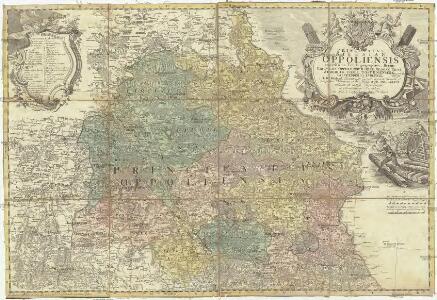
Principatvs Silesiae Oppoliensis
1 : 218000 Opolsko (Polsko) Wieland, Johann Wolfgang Homannianis Heredibus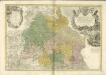

Mapa Górnego Śląska
1 : 600000 Horní Slezsko Gregor, Józef K. Miarka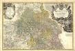
Principatvs Silesiae Oppoloniensis exactissima Tabula geographica, sistens Circvlos Oppoloniensem Ober-Glogav Gros Strehliz, Cosel, Tost, Rosenberg, Falckenberg & Lvblenitz.
1 : 216000 Mollova mapová sbírka Wieland, Johann Wolfgang Homann, Johann Baptista - dědici
Kartographische Darstellung der Abstimmungs-Ergebnisse von Oberschlesien
1 : 100000 [im Auftrag des Auswärtigen Amtes bearb. in der Plankammer des Preußisch-Statistischen Landesamtes vom Gerke] ; mit Genehmigung der Landesaufnahme, Berlin Berlin : Berliner Lithographisches Institut
Geognostische Karte von Ober-Schlesien
1 : 200000 Dolnoslezské vojvodství (Polsko) Carnall, Rudolph von Simmon Schropp & co.
Granica Polski na Śląsku górnym
1 : 600000 Polsko Instytut kartograficzny Atlas

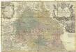
Das Fürstenthum Oppeln in Ober Schlesien
1 : 720000 Horní Slezsko Schleuen, Johann David I.D. Schleuen
Das Fürstenthum Oppeln in Ober Schlesien
Mollova mapová sbírka Schleuen, Johann David Schleuen, Johann David
Beuthen 92, uit: Special-Karte von Mittel-Europa / nach amtlichen Quellen bearbeitet von W. Liebenow
1 : 300000 titelvariant: W. Liebenow's Mittel-Europa; Annotatie: Titel boven de bladen: W. Liebenow's Mittel-Europa Johannes Wilhelm Liebenow 1822-1897 Frankfurt a. M. : Ludwig Ravenstein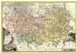
Principatvs Silesiae Rattiboriensis nova et exactissima Tabula geographica commonstrans insimul Liberas Dynastias Ples et Bevthen, cum Statu minore Loslav.
1 : 108000 Mollova mapová sbírka Wieland, Johann Wolfgang Homann, Johann Baptista - dědici
134. Brieg, uit: Topographische Uebersichtskarte des Deutschen Reiches / herausgegeben v. d. Kartogr. Abt. d. Königl. Preuß. Landesaufnahme
1 : 200000 titelvariant: Topogr. Übersichtskarte des Deutschen Reiches; Annotatie: Titel boven bladen ook: Topogr. Übersichtskarte des Deutschen Reiches; Annotatie geografische gegevens: Op elk blad twee maatstokken: 10 Kilometer = 5,5 cm; 1 geogr. Meile = 3,6 cm; Legenda onder op elk blad Königlich Preußische Landesaufnahme. Kartographische Abtheilung [S.l : Königlich Preußische Landesaufnahme, Kartographische Abtheilung]
Neisse 91, uit: Special-Karte von Mittel-Europa / nach amtlichen Quellen bearbeitet von W. Liebenow
1 : 300000 titelvariant: W. Liebenow's Mittel-Europa; Annotatie: Titel boven de bladen: W. Liebenow's Mittel-Europa Johannes Wilhelm Liebenow 1822-1897 Frankfurt a. M. : Ludwig Ravenstein
135. Lublinitz, uit: Topographische Uebersichtskarte des Deutschen Reiches / herausgegeben v. d. Kartogr. Abt. d. Königl. Preuß. Landesaufnahme
1 : 200000 titelvariant: Topogr. Übersichtskarte des Deutschen Reiches; Annotatie: Titel boven bladen ook: Topogr. Übersichtskarte des Deutschen Reiches; Annotatie geografische gegevens: Op elk blad twee maatstokken: 10 Kilometer = 5,5 cm; 1 geogr. Meile = 3,6 cm; Legenda onder op elk blad Königlich Preußische Landesaufnahme. Kartographische Abtheilung [S.l : Königlich Preußische Landesaufnahme, Kartographische Abtheilung]
Ducatus Silesiae Grotganus cum Districtu Episcopali Nissensi [Karte], in: Novus atlas absolutissimus, Bd. 2, S. 270.
1 Karte aus Atlas Janssonius Offizin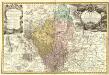
Principatvs Silesiae Grotkani exactissima Tabula geographica exhibens Terram Nissensem simul ac Circulos Grotkau Ottmuchau, et Ziegenhals.
1 : 154000 Mollova mapová sbírka Wieland, Johann Wolfgang Homann, Johann Baptista - dědici
Přehledná mapa panství biskupství Vratislavského v Československé republice podle stavu ke dni 1. ledna 1929
1 : 75000 Vratislav-oblast (Polsko) Bauer, E. Vojenský zeměpisný ústav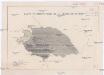
Carte ethnographique de la région de Ratiboř
Ratiboř (Polsko : oblast) Service cartographique de l'Armée Tchécoslovaque
DVCATVS SILESIÆ | GROTGANVS | cum Districtu Episcopali | NISSENSI
Amstelædami J. Blaeu excudit
171 Neisse, uit: Topographische Special-Karte von Deutschland (von Central-Europa) / begründet von D.G. Reymann ; [entworfen und gezeichn. von Heinrich Berghaus... [et al.]]
1 : 200000 Annotatie: Lit.: Daniel Gottlob Reymann und die "Topographische Special-Karte von Deutschland" / von Wolfgang Scharfe, in: Kartographische Nachrichten, 39 (1989), Heft I, p. 1-10; Handgeschreven titel: Reymann's Deutschland : 24 Sectionen: Jena, Penig, Dresden, Zittau, Hirschberg, Breslau, Brieg, Andernach, Coblenz, Giessen, Fulda, Schleusingen, Plauen, Zwickau, Teplitz, Jung Bunzlau, Hohenelbe, Glatz, Neisse, Simmern, Prag, Luxemburg, Birkenfeld; Aanwezig: 23 bladen Reymann, Daniel Gottlob; Berghaus, Heinrich [Berlin : 2. Departement des Kriegsministeriums, Bureau für Plan- und Kartenzeichnung]
Reymann ́s Special Karte 171 Neisse

146. Ratibor, uit: Topographische Uebersichtskarte des Deutschen Reiches / herausgegeben v. d. Kartogr. Abt. d. Königl. Preuß. Landesaufnahme
1 : 200000 titelvariant: Topogr. Übersichtskarte des Deutschen Reiches; Annotatie: Titel boven bladen ook: Topogr. Übersichtskarte des Deutschen Reiches; Annotatie geografische gegevens: Op elk blad twee maatstokken: 10 Kilometer = 5,5 cm; 1 geogr. Meile = 3,6 cm; Legenda onder op elk blad Königlich Preußische Landesaufnahme. Kartographische Abtheilung [S.l : Königlich Preußische Landesaufnahme, Kartographische Abtheilung]
Hotzenplotz und Zuckmantel.
from Spezialkarte der osterreichisch-ungarischen Monarchie.
147. Beuthen, uit: Topographische Uebersichtskarte des Deutschen Reiches / herausgegeben v. d. Kartogr. Abt. d. Königl. Preuß. Landesaufnahme
1 : 200000 titelvariant: Topogr. Übersichtskarte des Deutschen Reiches; Annotatie: Titel boven bladen ook: Topogr. Übersichtskarte des Deutschen Reiches; Annotatie geografische gegevens: Op elk blad twee maatstokken: 10 Kilometer = 5,5 cm; 1 geogr. Meile = 3,6 cm; Legenda onder op elk blad Königlich Preußische Landesaufnahme. Kartographische Abtheilung [S.l : Königlich Preußische Landesaufnahme, Kartographische Abtheilung]
Cosel
1 : 75000 Ministerstvo národní obrany
Lublinitz
1 : 75000 K. u. k. Militärgeographisches Institut
Karte des Deutschen Reiches 452 Kreuzburg