Maps of Olomoucký

[Die Markgraftschaft Mähren]
1 : 200000 Opava-oblast (Česko) Schenkl, Conrad Philipp Carl Winiker
Der Troppauer Kreis
1 : 200000 Jeseníky (Česko) Schenkl, Conrad Philipp Carl Winiker
Troppauer Kreis

Reisekarte durch die Mähr.-Schles.-Sudeten
1 : 200000 Jeseníky (Česko : pohoří) A. Blažek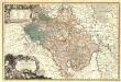
Principatvs Silesiae Oppaviensis novissima Tabula geographica.
1 : 150000 Mollova mapová sbírka Wieland, Johann Wolfgang Homann, Johann Baptista - dědici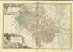
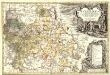
Tabula Generalis Marchionatus Moraviae in sex circulos divisae]
1 : 183000 Mollova mapová sbírka Müller, Johann Christoph Gastl, Jan Jiří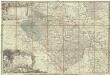
Principatvs Silesiae Oppaviensis novissima tabula geographica
1 : 150000 Opava-oblast (Česko) Wieland, Johann Wolfgang Schubarth, Matthäus Homannianos Heredes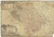
Principatvs Silesiae Oppaviensis novissima tabula geographica
1 : 150000 Opava-oblast (Česko) Wieland, Johann Wolfgang Schubarth, Matthäus Homannianos Heredes
Olmütz 105, uit: Special-Karte von Mittel-Europa / nach amtlichen Quellen bearbeitet von W. Liebenow
1 : 300000 titelvariant: W. Liebenow's Mittel-Europa; Annotatie: Titel boven de bladen: W. Liebenow's Mittel-Europa Johannes Wilhelm Liebenow 1822-1897 Frankfurt a. M. : Ludwig Ravenstein
Marchionatus Moraviae circulus Preroviensis
1 : 150000 Morava (Česko) Müller, Johann Christoph Homann, Johann Baptist Io. Baptista Homanno
Marchionatus Moraviae circulus Preroviensis
1 : 150000 Morava (Česko) Müller, Johann Christoph Homann, Johann Baptist Io. Baptista Homanno
Marchionatus Moraviae circulus Preroviensis
1 : 150000 Morava (Česko) Müller, Johann Christoph Homann, Johann Baptist editore Io. Baptista Homanno
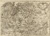
Marchionatus Moraviae Circulus Olomucensis pars Borealis

Marchionatus Moraviae Circulus Preroviensis.
1 : 233300 Mollova mapová sbírka Müller, Johann Christoph Homann, Johann Baptista
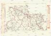
Komunikační mapa země Moravskoslezské
1 : 100000 Jeseník (Česko : oblast) Morslez. zem. výbor
Reymann ́s Special Karte 190 Troppau

[Circuli Olomucensis pars borealis]
1 : 150000 Morava (Česko) Müller, Johann Christoph
Circuli Olomucensis pars borealis
1 : 150000 Morava (Česko) Müller, Johann Christoph
Přehledná mapa panství biskupství Vratislavského v Československé republice podle stavu ke dni 1. ledna 1929
1 : 75000 Vratislav-oblast (Polsko) Bauer, E. Vojenský zeměpisný ústav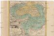
Die Fürstenthümer Troppau und Iaegerndorf in Ober-Schlesien
1 : 420000 Krnov-oblast (Česko) Schleuen, Johann David I.D. Schleuen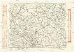
Komunikační mapa země Moravskoslezské
1 : 100000 Olomouc (Česko : oblast) Morslez. zem. výbor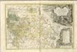
Principatvs Silesiae Karnoviensis nova et exactissima Tabula geographica, commonstrans insimul districtus ac Statvs Minores Frevdenthal Olbersdorf et Stevberndorf.
1 : 1125000 Mollova mapová sbírka Wieland, Johann Wolfgang Homann, Johann Baptista - dědici
Principatvs Silesiae Karnoviensis nova et exactissima tabula geographica commonstrans insimul districtus ac statvs minores Frevdenthal, Olbersdorf et Stevberndorf
1 : 100000 Bruntál-oblast (Česko) Wieland, Johann Wolfgang Schubarth, Matthäus Homannianos Heredes
Principatvs Silesiae Karnoviensis nova et exactissima tabula geographica commonstrans insimul districtus ac statvs minores Frevdenthal Olbersdorf et Stevberndorf
1 : 100000 Bruntál-oblast (Česko) Wieland, Johann Wolfgang Schubarth, Matthäus ab Haeredibus Homannianis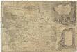
Principatvs Silesiae Karnoviensis nova et exactissima tabula geographica commonstrans insimul districtus ac Statvs minores Frevdenthal, Olbersdorf et Stevberndorf
1 : 100000 Bruntál-oblast (Česko) Wieland, Johann Wolfgang Schubarth, Matthäus Homannianos Heredes
Jeseníky

![[Die Markgraftschaft Mähren]](https://images-2.georeferencer.com/images/iiif/401208850002/full/,300/0/native.jpg)

