Maps of Illertissen

Meßtischblatt [7726] : Dietenheim, 1917
1 : 250000 Dietenheim. - 1:25000. - Stuttgart, 1917. - 1 Kt.
Ehingen, Weissenhorn a okolí]
Mollova mapová sbírka Bodenehr, Gabriel Bodenehr, Gabriel
179. Ulm, uit: Topographische Uebersichtskarte des Deutschen Reiches / herausgegeben v. d. Kartogr. Abt. d. Königl. Preuß. Landesaufnahme
1 : 200000 titelvariant: Topogr. Übersichtskarte des Deutschen Reiches; Annotatie: Titel boven bladen ook: Topogr. Übersichtskarte des Deutschen Reiches; Annotatie geografische gegevens: Op elk blad twee maatstokken: 10 Kilometer = 5,5 cm; 1 geogr. Meile = 3,6 cm; Legenda onder op elk blad Königlich Preußische Landesaufnahme. Kartographische Abtheilung [S.l : Königlich Preußische Landesaufnahme, Kartographische Abtheilung]
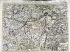
Die Lande der Grafen Fugger
1 Karte : Kupferdruck ; 20 x 25 cm Reilly F. J. J. von Reilly
Suevia Universa :
1 : 170000 Mollova mapová sbírka Michal, Jacques de Seutter, Matthäus Seutter, Matthäus
Des Herzogthums Würtemberg ostsüdliche Aemter mit der freyen Reichsstadt Giengen
1 Karte : Kupferdruck ; 23 x 26 cm Reilly F. J. J. von Reilly
Umgegend von Ulm
1 : 200000 Kartographischen Abtheilung konigl Preuss
München - Augsburg - Ulm

Suevia universa IX. tabulis delineata, 6
1 Blatt : s.n.
Theatrum des Krieges in der Marggrafschaft Burgau
Mollova mapová sbírka Stridbeck, Johann Stridbeck, Johann II
Ulm 142, uit: [W. Liebenow's Special-Karte von Mittel-Europa]
1 : 300000 titelvariant: W. Liebenow's Mittel-Europa; Annotatie: Titel boven de bladen: W. Liebenow's Mittel-Europa Johannes Wilhelm Liebenow 1822-1897 Hannover : Hermann Oppermann
Ulm 142, uit: Special-Karte von Mittel-Europa / nach amtlichen Quellen bearbeitet von W. Liebenow
1 : 300000 titelvariant: W. Liebenow's Mittel-Europa; Annotatie: Titel boven de bladen: W. Liebenow's Mittel-Europa Johannes Wilhelm Liebenow 1822-1897 Frankfurt a. M. : Ludwig Ravenstein
Suevia universa IX. tabulis delineata, 5
1 Blatt : s.n.
Le Theatre de Bellone :
Mollova mapová sbírka Schenk, Pieter Braakman, Adriaan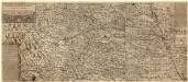
Ilerae Amnis ac Vtrinqve adiacentis Alemanniae Geographica descriptio
1 : 120000 Mollova mapová sbírka Hurter, Johann Christoph Custos, Raphael Hurter, Christoph
Das Bisthum Augsburg mit der freyen Reichsstadt Augsburg
1 Karte : Kupferdruck ; 31 x 18 cm Reilly F. J. J. von Reilly
Geographica provinciarum Sueviae descriptio, 4
4 Blätter : Johann Georg Bodenehr
Carte topographique d'Allemagne contenant une partie de Baviere les principautés de Wurtemberg, d'Oettingen
1 Karte : Kupferdruck ; 45 x 63 cm Jaeger se vend chez l'auteur
Per Inclyti Circuli Suevici Supremorum Ordinum :
1 : 160000 Mollova mapová sbírka Pfeffel, Johann Andreas Pfeffel, Johann Andreas I.
Per Inclyti Circuli Suevici Supremorum Ordinum
1 : 160000 Mollova mapová sbírka Pfeffel, Johann Andreas Homann, Johann Baptista - dědici
Generalkarte von Württemberg: Blatt IV
1 : 1500000 Terrainzeichnung: Bach, Topograf und Hauptmann Lithografie: Rebmann und Sommer Herausgeber: K. statistisch-topografisches Büro
Ducatus Wurtenbergici
1 : 250000 Mollova mapová sbírka Mejer, Johannes Homann, Johann Baptista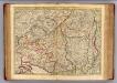
Souabe Meridionale
1 : 240000 L'Isle, Guillaume de, 1675-1726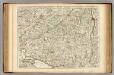
Souabe Meridionale.
1 : 240000 L'Isle, Guillaume de, 1675-1726
Pagi et Exstantiores quodam Comitatus Veteris Alamanniae et Burgundiae Transiuranat qui Augustae Genti Habsburgicae vel universi parebant, vel in quibus Gens illa ius suum exercebat
1 : 330000 Mollova mapová sbírka Weiss, Fr. Jos. Weiss, F. J.
Pars Sueviae australior
1 : 310000 Württembersko (Německo) Delisle, Guillaume Lotter, Tobias Conrad T. C. Lotter
Pars Sueviae Australior
1 : 250000 Mollova mapová sbírka Delisle, Guillaume Wolff, Jeremias
Der Lech-Fluss von Füessen im Algöw an, bis zu seinen Auslauff in die Donaw
Německo Bodenehr, Gabriel G. Bodenehr
![Meßtischblatt [7726] : Dietenheim, 1917](https://images-2.georeferencer.com/images/iiif/611428121150/full/,300/0/native.jpg)

