Maps of Alb-Donau-Kreis

Maps of Alb-Donau-Kreis

$title$

Umgegend von Ulm

1 : 200000 Kartographischen Abtheilung konigl Preuss
$title$

Die freye Reichsstadt Ulm mit ihrem Gebiete

1 Karte : Kupferdruck ; 19 x 27 cm Reilly F. J. J. von Reilly
$title$

$title$

Nova et accurata Territorii Vlmensis cum Dominio Wainensi Descriptio

1 : 100000 Mollova mapová sbírka Lauterbach, Johann Christoph Homann, Johann Baptista
$title$

Nova et accurata territorii Vlmensis cum dominio Wainensi descriptio

1 Karte : Kupferdruck ; 47 x 56 cm Lauterbach; Homann Johann Baptist Homann
$title$

Nova et accurata territorii Vlmensis cum dominio Wainensi descriptio

1 Karte : Kupferdruck ; 47 x 56 cm Lauterbach; Homann Johann Baptist Homann
$title$

Nova et accurata territorii Vlmensis cum dominio Wainensi descriptio

1 : 100000 Bádensko-Württembersko (Německo) Lauterbach, Johann Christoph Homann, Johann Baptist Ioh. Baptista Homann
$title$

$title$

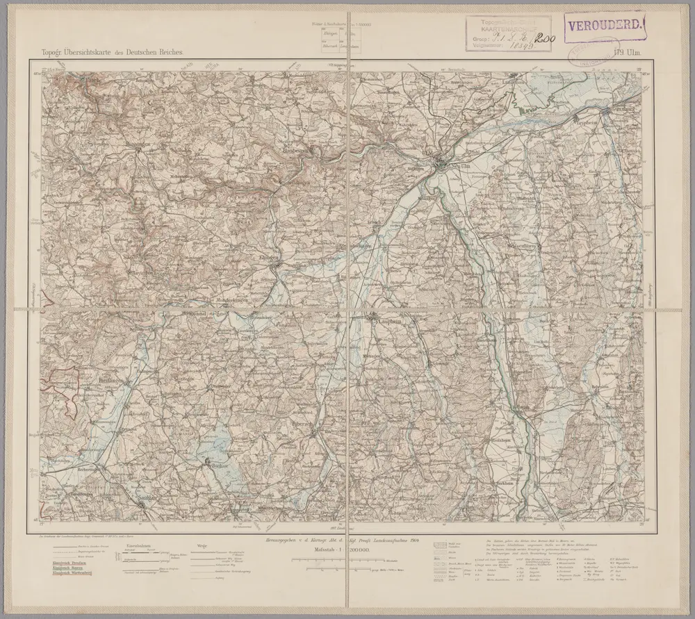
179. Ulm, uit: Topographische Uebersichtskarte des Deutschen Reiches / herausgegeben v. d. Kartogr. Abt. d. Königl. Preuß. Landesaufnahme

1 : 200000 titelvariant: Topogr. Übersichtskarte des Deutschen Reiches; Annotatie: Titel boven bladen ook: Topogr. Übersichtskarte des Deutschen Reiches; Annotatie geografische gegevens: Op elk blad twee maatstokken: 10 Kilometer = 5,5 cm; 1 geogr. Meile = 3,6 cm; Legenda onder op elk blad Königlich Preußische Landesaufnahme. Kartographische Abtheilung [S.l : Königlich Preußische Landesaufnahme, Kartographische Abtheilung]
$title$

Des Herzogthums Würtemberg ostsüdliche Aemter mit der freyen Reichsstadt Giengen : Nro. 189

Reilly, Franz Johann Joseph von
$title$

Die Lande der Grafen Fugger

1 Karte : Kupferdruck ; 20 x 25 cm Reilly F. J. J. von Reilly
$title$

Nieuwe Kaart, van t'Land Donawert, en Hochstett &c.

1 : 200000 Mollova mapová sbírka Visscher, Nicolaes Jansz. Visscher, Nicolaus II.
$title$

Geographica Provinciarum Sveviae Descriptio =

Mollova mapová sbírka Hurter, Johann Christoph Bodenehr, Gabriel
$title$

$title$

Die Lande der Grafen Fugger mit den Herrschaften Thannhausen, Schwabeck, und Mindelheim den Benachbarten Abteyen un der freyen Reichsstadt Kaufbeuren

1 : 245000 Švábsko (Německo)
$title$

Novissima delineatio Marchionatus Burgoviae

1 : 150000 Mollova mapová sbírka Michal, Jacques de Seutter, Matthäus
$title$

Ulm mit der Gegend auf 1 1/4 Stund

Mollova mapová sbírka Bodenehr, Gabriel Bodenehr, Gabriel
$title$

Ulm mit dero Gegend auf 2 Stund.

1 : 150000 Mollova mapová sbírka Bodenehr, Gabriel Bodenehr, Gabriel
$title$

Ehingen, Weissenhorn a okolí]

Mollova mapová sbírka Bodenehr, Gabriel Bodenehr, Gabriel
$title$

Biberach, Guttenzell, Munchrott, Buxheim a okolí]

Mollova mapová sbírka Bodenehr, Gabriel Bodenehr, Gabriel
$title$

Closter Rockenburg, Closter Uhrsperg, M. Tanhaussen, Kirchheim a okolí]

Mollova mapová sbírka Bodenehr, Gabriel Bodenehr, Gabriel
$title$

Geographica Provinciarum Sveviae Descriptio =

Mollova mapová sbírka Hurter, Johann Christoph Bodenehr, Johann Georg
$title$

Abriss des Territorii Ulmensis Ultra-Danubialis, Sambt denen Beeden Wildpan. bezürcken

1 : 100000 Mollova mapová sbírka Mayer, Bartholomaeus Bodenehr, Gabriel
$title$

Lande der Grafen Fugger mit den Herrschaften Thannhausen, Schwabeck und Mindelheim, den Benachbarten Abteyen und der freyen Reichsstadt Kaufbeuren

Reilly, Franz Johann Joseph von
$title$

Protoparchiae Mindelhemensis Nova Tabula Geographica

1 : 40000 Mollova mapová sbírka Homann, Johann Baptist Homann, Johann Baptista
$title$

Territorium der des H. R. R. Statt Memmingen samt denen angräntzenden Herrschafften.

1 : 2800 Mollova mapová sbírka Bodenehr, Gabriel Bodenehr, Gabriel
$title$

Geographica Provinciarum Sveviae Descriptio =

Mollova mapová sbírka Hurter, Johann Christoph Bodenehr, Gabriel
$title$

Lauingen und Confinen

Mollova mapová sbírka Bodenehr, Gabriel Bodenehr, Gabriel
$title$

Lauingen und Confinen

1 : 140000 Mollova mapová sbírka Bodenehr, Gabriel Bodenehr, Gabriel
$title$

Memingen, Babenhausen, Mindelheim a okolí]

Mollova mapová sbírka Bodenehr, Gabriel Bodenehr, Gabriel
© MapTiler © OpenStreetMap contributors
How does it work?
These instructions will show you how to find historical maps online.
Getting started
Type the place name in the search box to find the exact location. You can further adjust the search by zooming in and out.
Zoom
Zoom in and out with the buttons or use your mouse or touchpad natively.
Exact Area tool
Click here and draw a rectangle over the map to precisely define the search area.
Set filters
Narrow your search with advanced settings, such as Years (from/to), Fulltext, Publisher, etc.
Results
See the results of your search on the right side. You can scroll down to find more maps of this location.
?

Download OldMapsOnline Mobile