Maps of Landkreis Biberach

Ulm 142, uit: Special-Karte von Mittel-Europa / nach amtlichen Quellen bearbeitet von W. Liebenow
1 : 300000 titelvariant: W. Liebenow's Mittel-Europa; Annotatie: Titel boven de bladen: W. Liebenow's Mittel-Europa Johannes Wilhelm Liebenow 1822-1897 Frankfurt a. M. : Ludwig Ravenstein
Ulm 142, uit: [W. Liebenow's Special-Karte von Mittel-Europa]
1 : 300000 titelvariant: W. Liebenow's Mittel-Europa; Annotatie: Titel boven de bladen: W. Liebenow's Mittel-Europa Johannes Wilhelm Liebenow 1822-1897 Hannover : Hermann Oppermann
Per Inclyti Circuli Suevici Supremorum Ordinum :
1 : 160000 Mollova mapová sbírka Pfeffel, Johann Andreas Pfeffel, Johann Andreas I.
Per Inclyti Circuli Suevici Supremorum Ordinum
1 : 160000 Mollova mapová sbírka Pfeffel, Johann Andreas Homann, Johann Baptista - dědici
Generalkarte von Württemberg: Blatt IV
1 : 1500000 Terrainzeichnung: Bach, Topograf und Hauptmann Lithografie: Rebmann und Sommer Herausgeber: K. statistisch-topografisches Büro
Suevia universa IX. tabulis delineata, 5
1 Blatt : s.n.
Suevia Universa :
1 : 170000 Mollova mapová sbírka Michal, Jacques de Seutter, Matthäus Seutter, Matthäus

Le Theatre de Bellone :
Mollova mapová sbírka Schenk, Pieter Braakman, Adriaan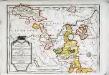
Das Fürstenthum Hohenzollern und die Grafschaft Sigmaringen
1 Karte : Kupferdruck ; 19 x 27 cm Reilly F. J. J. von Reilly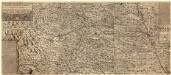
Ilerae Amnis ac Vtrinqve adiacentis Alemanniae Geographica descriptio
1 : 120000 Mollova mapová sbírka Hurter, Johann Christoph Custos, Raphael Hurter, Christoph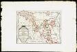
Das Fürstenthum Hohenzollern und die Grafschaft Sigmaringen mit der gefürsteten Abtey Buchau, der Deutschen Ordens Komthurey Alschhausen, der Herrschaft Justingen, den Abteÿen um den Federsee ...
Reilly, Franz Johann Joseph von
179. Ulm, uit: Topographische Uebersichtskarte des Deutschen Reiches / herausgegeben v. d. Kartogr. Abt. d. Königl. Preuß. Landesaufnahme
1 : 200000 titelvariant: Topogr. Übersichtskarte des Deutschen Reiches; Annotatie: Titel boven bladen ook: Topogr. Übersichtskarte des Deutschen Reiches; Annotatie geografische gegevens: Op elk blad twee maatstokken: 10 Kilometer = 5,5 cm; 1 geogr. Meile = 3,6 cm; Legenda onder op elk blad Königlich Preußische Landesaufnahme. Kartographische Abtheilung [S.l : Königlich Preußische Landesaufnahme, Kartographische Abtheilung]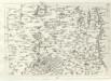
Geographica Provinciarum Sveviae Descriptio =
Mollova mapová sbírka Hurter, Johann Christoph Bodenehr, Johann Georg
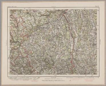
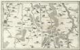
Umgegend von Ulm
1 : 200000 Kartographischen Abtheilung konigl Preuss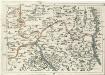
Geographica Provinciarum Sveviae Descriptio =
Mollova mapová sbírka Hurter, Johann Christoph Bodenehr, Gabriel
Die Lande der Grafen Fugger
1 Karte : Kupferdruck ; 20 x 25 cm Reilly F. J. J. von Reilly
Suevia Universa :
1 : 170000 Mollova mapová sbírka Michal, Jacques de Seutter, Matthäus Seutter, Matthäus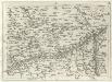
Geographica Provinciarum Sveviae Descriptio =
Mollova mapová sbírka Hurter, Johann Christoph Bodenehr, Johann Georg
187. Lindau, uit: Topographische Uebersichtskarte des Deutschen Reiches / herausgegeben v. d. Kartogr. Abt. d. Königl. Preuß. Landesaufnahme
1 : 200000 titelvariant: Topogr. Übersichtskarte des Deutschen Reiches; Annotatie: Titel boven bladen ook: Topogr. Übersichtskarte des Deutschen Reiches; Annotatie geografische gegevens: Op elk blad twee maatstokken: 10 Kilometer = 5,5 cm; 1 geogr. Meile = 3,6 cm; Legenda onder op elk blad Königlich Preußische Landesaufnahme. Kartographische Abtheilung [S.l : Königlich Preußische Landesaufnahme, Kartographische Abtheilung]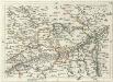
Geographica Provinciarum Sveviae Descriptio =
Mollova mapová sbírka Hurter, Johann Christoph Bodenehr, Gabriel
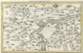
Ehingen, Weissenhorn a okolí]
Mollova mapová sbírka Bodenehr, Gabriel Bodenehr, Gabriel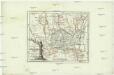
Die Lande der Grafen Fugger mit den Herrschaften Thannhausen, Schwabeck, und Mindelheim den Benachbarten Abteyen un der freyen Reichsstadt Kaufbeuren
1 : 245000 Švábsko (Německo)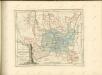
Biberach, Guttenzell, Munchrott, Buxheim a okolí]
Mollova mapová sbírka Bodenehr, Gabriel Bodenehr, Gabriel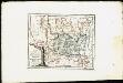
Lande der Grafen Fugger mit den Herrschaften Thannhausen, Schwabeck und Mindelheim, den Benachbarten Abteyen und der freyen Reichsstadt Kaufbeuren
Reilly, Franz Johann Joseph von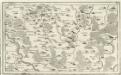
Ottenbeüren, Güntzberg, Ursin oder Yrsee a okolí]
Mollova mapová sbírka Bodenehr, Gabriel Bodenehr, Gabriel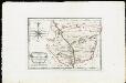
Die gefürstete Abtey Kempten mit der freyen Reichsstadt Kempten : Nro. 183
Reilly, Franz Johann Joseph von
Protoparchiae Mindelhemensis Nova Tabula Geographica
1 : 40000 Mollova mapová sbírka Homann, Johann Baptist Homann, Johann Baptista