Maps of Derbyshire

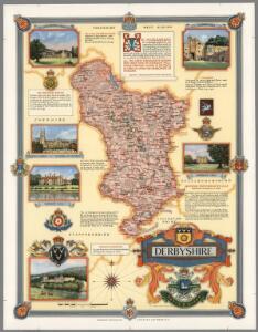
Derbyshire. Designed and drawn by Ernest Clegg
1 : 285000 Clegg, Ernest
An accurate map of the county of Derby
1 Karte : Kupferdruck ; 68 x 52 cm Bowen; Tinney; Bowles; Sayer; Bowles; Bowles sold by R. Sayer at the Golden Buck and I. Tinney at the Golden Lion in Fleet street T. Bowles in St. Pauls Church yard and I. Bowles and son in Cornhill
Darbiensis comitatvs vernacule Darbie Shire
1 Karte : Kupferdruck ; 37 x 48 cm Blaeu Joan Blaeu
Comitatvs Darbiensis
1 Karte : Kupferdruck ; 36 x 47 cm Valck; Schenk apud G. Valk et P. Schenk

Comitatus Darbiensis
1 : 240000 [Amstelodami] : [apud Joannem Janssonium]
DARBIENSIS | COMITATVS. | Vernacule | DARBIE SHIRE
[Amsterdam : Joan Blaeu]
Derby & Nottingham, Sheet 13 - Bartholomew's "Half Inch to the Mile Maps" of England & Wales
1 : 126720 Topographic maps Bartholomew, John George John Bartholomew & Co
Buxton and Matlock - OS One-Inch Map
1 : 63360 Topographic maps Ordnance Survey Ordnance Survey
Burton upon Trent - OS One-Inch Map
1 : 63360 Topographic maps Ordnance Survey Ordnance Survey
Sudbury Park
1 : 31680 The county boundary of Derbyshire and Staffordshire is indicated by a red pecked line. The boundary closely follows the River Dove. In the margins of the drawing several dots annotated with place names indicate observation stations. This is where the surveyor stood to take triangulation measurements. No indications of relief are given, suggesting that this is an outline plan, the midpoint between the original protraction and the finished drawing. The road network is precisely delineated. Major communication routes are coloured yellow, following military cartographic convention. Stevens, Henry
Hartshorn
1 : 31680 .The attention to communications routes shown on this map conforms well to the military and cartographic standards employed by the Survey. Sections of the Grand Trunk and Derby Canals are shown in blue, with individual locks distinguishable around Newton Solney. Woods are indicated,on this plan,by the use of a green tint, meadows by a lighter green and arable land by a brown shade. Some fields are named. This drawing is formally titled and the area of the land is recorded at the top left margin as,totalling 88 square miles. Stevens, Henry
Sheffield (Hills) - OS One-Inch Revised New Series
1 : 63360 Topographic maps Ordnance Survey Ordnance Survey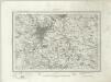
Sheffield (Outline) - OS One-Inch Revised New Series
1 : 63360 Topographic maps Ordnance Survey Ordnance Survey
Chesterfield (Hills) - OS One-Inch Revised New Series
1 : 63360 Topographic maps Ordnance Survey Ordnance Survey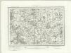
Chesterfield (Outline) - OS One-Inch Revised New Series
1 : 63360 Topographic maps Ordnance Survey Ordnance Survey
Derby (Hills) - OS One-Inch Revised New Series
1 : 63360 Topographic maps Ordnance Survey Ordnance Survey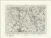
Derby (Outline) - OS One-Inch Revised New Series
1 : 63360 Topographic maps Ordnance Survey Ordnance Survey
Loughborough (Hills) - OS One-Inch Revised New Series
1 : 63360 Topographic maps Ordnance Survey Ordnance Survey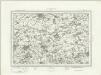
Loughborough (Outline) - OS One-Inch Revised New Series
1 : 63360 Topographic maps Ordnance Survey Ordnance Survey
Chapel en le Frith (Hills) - OS One-Inch Revised New Series
1 : 63360 Topographic maps Ordnance Survey Ordnance Survey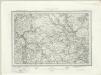
Chapel en le Frith (Outline) - OS One-Inch Revised New Series
1 : 63360 Topographic maps Ordnance Survey Ordnance Survey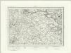
Buxton (Outline) - OS One-Inch Revised New Series
1 : 63360 Topographic maps Ordnance Survey Ordnance Survey
Buxton (Hills) - OS One-Inch Revised New Series
1 : 63360 Topographic maps Ordnance Survey Ordnance Survey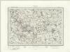
Ashbourne (Outline) - OS One-Inch Revised New Series
1 : 63360 Topographic maps Ordnance Survey Ordnance Survey
Ashbourne (Hills) - OS One-Inch Revised New Series
1 : 63360 Topographic maps Ordnance Survey Ordnance Survey
Burton upon Trent (Hills) - OS One-Inch Revised New Series
1 : 63360 Topographic maps Ordnance Survey Ordnance Survey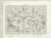
Burton upon Trent (Outline) - OS One-Inch Revised New Series
1 : 63360 Topographic maps Ordnance Survey Ordnance Survey
Ashbourne
1 : 31680 The absence of hill sketching on this drawing suggests it is an incomplete or 'rough' copy. A triangulation diagram appears on the reverse. This enabled the draughtsman to plot prominent features of the landscape. Major lines of communication are coloured yellow, following standard military cartographic convention. Notes in the margins of the drawing record the date it was received at the "Ord[nance] Map Office" and that it has been reduced and drawn for the engravers. Drawings were reduced to a scale of one inch to the mile for the final engraved sheets.