Maps of Derbyshire

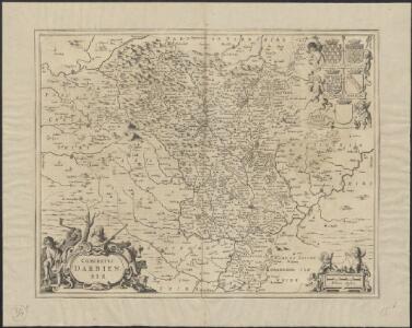
Comitatus Darbiensis
1 : 240000 [Amstelodami] : [apud Joannem Janssonium]
Comitatus Darbiensis. [Karte], in: Novus atlas absolutissimus, Bd. 7, S. 337.
1 Karte aus Atlas Janssonius Offizin
UNIVERSI Derbiensis Comitatus Sheet 25
This map ofDerbyshire is from the 1583 edition of the Saxton atlas of England and Wales.This atlas was first published as a whole in 1579. It consists of 35 coloured maps depicting the counties of England and Wales. The atlas is of great significance to British cartography as it set a standard of cartographic representation in Britain and the maps remained the basis for English county mapping, with few exceptions, until after 1750. During the reign of Elizabeth I map use became more common, with many government matters referring to increasingly accurate maps with consistent scales and symbols, made possible by advances in surveying techniques. Illustrating the increasing used of maps in government matters, Lord Burghley, Elizabeth I’s Secretary of State, who had been determined to have England and Wales mapped in detail from the 1550s, selected the cartographer Christopher Saxton to produce a detailed and consistent survey of the country. The financier of the project was Thomas Seckford Master of Requests at the Court of Elizabeth I, whose arms appear, along with the royal crest, on each map. Saxton, Christopher Ryther, Augustine
UNIVERSI Derbiensis Comitatus f.55
This is a map of Derbyshire by Christopher Saxton dating from 1577. It forms part of an atlas that belonged to William Cecil Lord Burghley, Elizabeth I’s Secretary of State. Lord Burghley used this atlas to illustrate domestic matters. This map is actually a proof copy of one which forms part of Christopher Saxton’s Atlas of England and Wales. This atlas was first published as a whole in 1579. It consists of 35 coloured maps depicting the counties of England and Wales. The atlas is of great significance to British cartography as it set a standard of cartographic representation in Britain and the maps remained the basis for English county mapping, with few exceptions, until after 1750. During the reign of Elizabeth I, map use became more common, with many government matters referring to increasingly accurate maps with consistent scales and symbols, made possible by advances in surveying techniques. Illustrating the increasing use of maps in government matters, Lord Burghley, who had been determined to have England and Wales mapped in detail from the 1550s, selected the cartographer Christopher Saxton to produce a detailed and consistent survey of the country. The financier of the project was Thomas Seckford Master of Requests at the Court of Elizabeth I, whose arms appear, along with the royal crest, on each map. Lord Burghley has annotated this map, adding several place names.The name of the engraver is not included but it is the work of one of a team of seven English and Flemish engravers employed to produce the copper plates for the atlas. Saxton, Christopher William Cecil, Lord Burghley
Darbiensis Comitatus. Vernacule Darbie Shire. [Karte], in: Theatrum orbis terrarum, sive, Atlas novus, Bd. 4, S. 351.
1 Karte aus Atlas Blaeu, Joan Blaeu, Willem Janszoon
Darbiensis Comitatus. Vernacule Darbie Shire. [Karte], in: Le théâtre du monde, ou, Nouvel atlas contenant les chartes et descriptions de tous les païs de la terre, Bd. 4, S. 305.
1 Karte aus Atlas Blaeu, Willem Janszoon und Blaeu, Joan Blaeu, Willem Janszoon
DARBIENSIS | COMITATVS. | Vernacule | DARBIE SHIRE
[Amsterdam : Joan Blaeu]
Darbiensis Comitatus. Vernacule Darbie Shire. [Karte], in: Theatrum orbis terrarum, sive, Atlas novus, Bd. 4, S. 351.
1 Karte aus Atlas Blaeu, Joan Blaeu, Willem Janszoon
Comitatvs Darbiensis
1 Karte : Kupferdruck ; 36 x 47 cm Valck; Schenk apud G. Valk et P. Schenk
Geological Survey of England and Wales
1 : 409000 Anglie Ordnance Survey Office
Derbyshire. Designed and drawn by Ernest Clegg
1 : 285000 Clegg, Ernest
Comitatus Nottinghamiensis; Sive Nottingham Shire. [Karte], in: Novus atlas absolutissimus, Bd. 7, S. 334.
1 Karte aus Atlas Janssonius Offizin
An accurate map of the county of Derby
1 Karte : Kupferdruck ; 68 x 52 cm Bowen; Tinney; Bowles; Sayer; Bowles; Bowles sold by R. Sayer at the Golden Buck and I. Tinney at the Golden Lion in Fleet street T. Bowles in St. Pauls Church yard and I. Bowles and son in Cornhill
Darbiensis comitatvs vernacule Darbie Shire
1 Karte : Kupferdruck ; 37 x 48 cm Blaeu Joan Blaeu
Derby & Nottingham, Sheet 13 - Bartholomew's "Half Inch to the Mile Maps" of England & Wales
1 : 126720 Topographic maps Bartholomew, John George John Bartholomew & Co
COMITATVS | NOTTINGHA- | MIENSIS; | NOTTINGHAM SHIRE.
[Amsterdam : Joan Blaeu]
Comitatus Nottinghamiensis, sive Nottingham Shire
1 : 240000 [Amstelodami] : [apud Joannem Janssonium]
An improved map of the county of Stafford
1 Karte : Kupferdruck ; 67 x 51 cm Bowen; Hinton sold by I. Hinton at the Kings Arms in St. Pauls Church Yard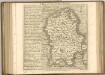

Staffordiensis comitatvs; vulgo Stafford Shire
1 Karte : Kupferdruck ; 39 x 49 cm Blaeu Joan Blaeu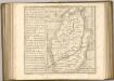

An accurate map of Nottingham Shire
1 Karte : Kupferdruck ; 68 x 52 cm Bowen; Tinney; Bowles; Sayer; Bowles; Bowles printed for T. Bowles in St. Pauls Church Yard John Bowles and son in Cornhil John Tinney and Robert Sayer in Fleet street
Comitatvs Nottinghamiensis
1 Karte : Kupferdruck ; 37 x 48 cm Blaeu Joan Blaeu
Buxton and Matlock - OS One-Inch Map
1 : 63360 Topographic maps Ordnance Survey Ordnance Survey
Nottingham - OS One-Inch Map
1 : 63360 Topographic maps Ordnance Survey Ordnance Survey
Burton upon Trent - OS One-Inch Map
1 : 63360 Topographic maps Ordnance Survey Ordnance Survey
Derby and Leicester - OS One-Inch Map
1 : 63360 Topographic maps Ordnance Survey Ordnance Survey
Nottingham 12
1 : 31680 This drawing covers,the border territory,of Nottinghamshire and Leicestershire, the county boundary being indicated by a red dotted line at lower right. The city of Nottingham and the broad floodplain,that characterises this part of the Trent Valley,are depicted at the top of the sheet., The undulating countryside of the Nottinghamshire Wolds is represented by soft brushwork interlining ('hachuring') in the lower part of the sheet. Stevens, Henry