Maps of Helgoland

Composite: 79a. Helgoland. (Germany)
1 : 100000 Reichsamt fur Landesaufnahme
79a. Helgoland. (Germany)
1 : 100000 Reichsamt fur Landesaufnahme
Meßtischblatt 488a, neue Nr. 1813 : Helgoland, 1892
1 : 250000 Helgoland. - Aufn. 1882, hrsg. 1892. - 1:25000. - [Berlin]: Reichsamt für Landesaufnahme, 1892. - 1 Kt.
[top] HELGELANDIA | Ao. 1649; [bottom] HELGELANDT | in annis Christi 800. | 1300 & 1649.
Matthias Vnd Clauss Petersen | G.S. gebr. Husumenss. sculps. [Amsterdam : Joan Blaeu]
Charte von der Insel Helgoland vor der Elbe mündung in der Nordsee gelegen
Helgoland (Německo)
[Helgoland]
Helgoland (Německo)
Tönning 20, uit: Special-Karte von Mittel-Europa / nach amtlichen Quellen bearbeitet von W. Liebenow
1 : 300000 titelvariant: W. Liebenow's Mittel-Europa; Annotatie: Titel boven de bladen: W. Liebenow's Mittel-Europa Johannes Wilhelm Liebenow 1822-1897 Frankfurt a. M. : Ludwig Ravenstein
Tönning 20, uit: [W. Liebenow's Special-Karte von Mittel-Europa]
1 : 300000 titelvariant: W. Liebenow's Mittel-Europa; Annotatie: Titel boven de bladen: W. Liebenow's Mittel-Europa Johannes Wilhelm Liebenow 1822-1897 Hannover : Hermann Oppermann
Nobilis Saxoniae Fl. Visurgis, cum Terris adjacentib. Ab Inclyta Brema, ad ostium maris. [Karte, Teil 2], in: Novus atlas absolutissimus, Bd. 2, S. 100.
1 Karte aus Atlas Janssonius Offizin
Ducatus: olim Episcopatus Bremensis et ostiorum Albis et Visurgis Fluviorum novissima Descriptio. [Karte], in: Novus atlas absolutissimus, Bd. 2, S. 106.
1 Karte aus Atlas Janssonius Offizin
[Pas-Caarte van't Schager-Rack, De Sondt en de Belt. [Karte] Paskaartie van de Rievier de Elve. [...] [Nebenkarte], in: De Nieuwe Groote Vermeerderde Zee-Atlas ofte Water-Werelt, S. 19.
1 Karte aus Atlas Doncker, Hendrick
Nieuwe Caerte waerinne vertoont wordt de gantsche Vaert van Amsterdam over de Watten tot de stadt Hamborch toe. [Karte, Teil 2], in: Gerardi Mercatoris et I. Hondii Newer Atlas, oder, Grosses Weltbuch, Bd. 1, S. 152.
1 Karte aus Atlas Mercator, Gerhard und Hondius, Jodocus Jansson, Jan
Nieuwe Caerte waerinne vertoont wordt de gantsche Vaert van Amsterdam over de Watten tot de stadt Hamborch toe. [Karte, Teil 2], in: Novus atlas absolutissimus, Bd. 2, S. 95.
1 Karte aus Atlas Janssonius Offizin
Holsatiae Ducatus, Vernaculè Das Hertzogtum Holstein
1 : 310000 Mollova mapová sbírka Visscher, Nicolaes Schenk, Peter II
Geographische Vorstellung der jämerlichen Wasser-Flutt in Nieder-Teutschland
1 : 590000 Mollova mapová sbírka Homann, Johann Baptist Homann, Johann Baptista
Ducatus Holsatiae Nova Tabula [Karte] Alluvies propè Detzbul [...] [Nebenkarte] Tabula Barmerensis [...] [Nebenkarte] , in: Gerardi Mercatoris et I. Hondii Newer Atlas, oder, Grosses Weltbuch, Bd. 1, S. 109.
1 Karte aus Atlas Mercator, Gerhard und Hondius, Jodocus Jansson, Jan
Ducatus Holsatiae Nova Tabula [Karte] Alluvies propè Detzbul [...] [Nebenkarte] Tabula Barmerensis [...] [Nebenkarte], in: Novus Atlas, das ist, Weltbeschreibung, Bd. 1, S. 114.
1 Karte aus Atlas Blaeu, Joan Blaeu, Willem Janszoon
Ducatus Holsatiae Nova Tabula [Karte] Alluvies propè Detzbul [...] [Nebenkarte] Tabula Barmerensis [...] [Nebenkarte] , in: Novus atlas absolutissimus, Bd. 1, S. 143.
1 Karte aus Atlas Janssonius Offizin
Ducatus Holsatiae Nova Tabula [Karte] Alluvies propè Detzbul [...] [Nebenkarte] Tabula Barmerensis [...] [Nebenkarte], in: Le théâtre du monde, ou, Nouvel atlas contenant les chartes et descriptions de tous les païs de la terre, Bd. 1, S. 143.
1 Karte aus Atlas Blaeu, Willem Janszoon und Blaeu, Joan Blaeu, Willem Janszoon
Holsatiae Tabula Generalis
1 : 310000 Mollova mapová sbírka Wit, Frederik de Mortier, Pierre
Ducatus Holsatiae Descriptio Novissima
1 : 490000 Mollova mapová sbírka Visscher, Nicolaes Visscher, Nicolaus
Ducatus Holsatiae Descriptio Novissima
1 : 490000 Mollova mapová sbírka Visscher, Nicolaes Jansz. Visscher, Nicolaus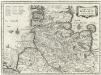
Dvcatvs Holsatiae Nova Tabvla
1 : 850000 Mollova mapová sbírka Merian, Matthaeus Merian, Matthäus - dědici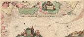
Paskaarte vande kuste van Holland en Vriesland
1 : 300000 Mollova mapová sbírka Guitet, Mathurin Keulen, Johannes van II
De westkust van Jutland van Beusem tot aan 't Jutsche Riff
Denmark Johannes van Keulen
NOVA & ACCVRATA | DVCATVVM | SLESVICI | ET | HOLSATIÆ | TABVLA.
Matthias und Nicolaus Pet. Goldtschmide gebr. | Hus. Cimb. sculps. [Amsterdam : Joan Blaeu]
Bäderkarte der deutschen Nordsee - Küste

Hamburg, Wilhelmshaven, Schleswig
1 : 750000 Hamburk (Německo : oblast) Cronenberg, Eduard von K. u. k. Militärgeographisches Institut
Hamburg, Wilhelmshaven, Schleswig
1 : 750000 Hamburk (Německo : oblast) K. k. militär-geographisches Institut


