Maps of Ostfriesland

[Pas-Caarte van't Schager-Rack, De Sondt en de Belt. [Karte] Paskaartie van de Rievier de Elve. [...] [Nebenkarte], in: De Nieuwe Groote Vermeerderde Zee-Atlas ofte Water-Werelt, S. 19.
1 Karte aus Atlas Doncker, Hendrick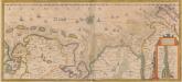
Nieuwe Caerte waerinne vertoont wordt de gantsche Vaert van Amsterdam over de Watten tot de stadt Hamborch toe. [Karte, Teil 2], in: Novus atlas absolutissimus, Bd. 2, S. 95.
1 Karte aus Atlas Janssonius Offizin
Nieuwe Caerte waerinne vertoont wordt de gantsche Vaert van Amsterdam over de Watten tot de stadt Hamborch toe. [Karte, Teil 2], in: Gerardi Mercatoris et I. Hondii Newer Atlas, oder, Grosses Weltbuch, Bd. 1, S. 152.
1 Karte aus Atlas Mercator, Gerhard und Hondius, Jodocus Jansson, Jan
Geographische Vorstellung der jämerlichen Wasser-Flutt in Nieder-Teutschland
1 : 590000 Mollova mapová sbírka Homann, Johann Baptist Homann, Johann Baptista
Tabula Frisiae orientalis
1 : 210000 Aurich (Německo) Coldewey, Ehrenreich Gerhard Allard, Abraham ex officina Ioh. Christoph. Homanni
Tabula Frisiae orientalis
1 : 210000 Aurich (Německo) Coldewey, Ehrenreich Gerhard Allard, Abraham ex officina Ioh. Christoph. Homanni
Ducatus Bremae & Ferdae maximaeque partis fluminis Visurgis
1 : 326500 Brémy (Německo : spolková země) Wit, Frederick de R. & J. Ottens
DUCATUS BREMAE & FERDAE Maximaeque partis FLUMINIS VISURGIS
1 : 340000 Brémy (Německo : spolková země) Wit, Frederick de Frederic de Wit
Ducatus Bremae & Ferdae maximaeque partis fluminis Visurgis
1 : 326500 Brémy (Německo : spolková země) Wit, Frederick de I. Covens et C. Mortier

Emden & Olden Borch Comit. [Karte], in: Gerardi Mercatoris Atlas, sive, Cosmographicae meditationes de fabrica mundi et fabricati figura, S. 337.
1 Karte aus Atlas Mercator, Gerhard Montanus, Petrus
Oost-Frise, ou Le Comté D'Embden subdivisé en ses principales Iurisditions. [Karte], in: Atlas nouveau, contenant toutes les parties du monde [...], Bd. 2, S. 93.
1 Karte aus Atlas Sanson, Nicolas Jaillot, Alexis Hubert und Mortier, Pieter
[4], uit: Hydro-Oro und Chorographische General Karte des Koenigreichs der Niederlande und der angrenzenden Länder bis Paris : mit der Angabe der Kunst und Heer-Strassen und der Entfernung der Poststationen / ... zusammengetragen und reducirt von ... Wilhelm Müller
1 : 400000 titelvariant: Generalkarte des Koenigreichs Hannover; Annotatie: 1e supplement bij: Generalkarte des Koenigreichs Hannover (1818) Müller, Wilhelm (fl. 1818) [Hannover : Wilhelm Müller]
Wilhelmshaven 32, uit: Special-Karte von Mittel-Europa / nach amtlichen Quellen bearbeitet von W. Liebenow
1 : 300000 titelvariant: W. Liebenow's Mittel-Europa; Annotatie: Titel boven de bladen: W. Liebenow's Mittel-Europa Johannes Wilhelm Liebenow 1822-1897 Frankfurt a. M. : Ludwig Ravenstein
La Principauté d'Ost-Frise ou le Comté d'Embden : avec ses principales jurisdictions
1 : 210000 carte dessinée de nouveau par Tob. Conrad Lotter gravé par Georg Frederic Lotter Augsburg : Tob. Conrad Lotter
Typus Frisiae Orientalis. [Karte], in: Gerardi Mercatoris et I. Hondii Newer Atlas, oder, Grosses Weltbuch, Bd. 1, S. 149.
1 Karte aus Atlas Mercator, Gerhard und Hondius, Jodocus Jansson, Jan
Typus Frisiae Orientalis. [Karte] Rideriae Portionis [...] [Nebenkarte], in: Novus atlas absolutissimus, Bd. 2, S. 112.
1 Karte aus Atlas Janssonius Offizin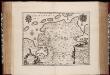
Typvs Frisiæ Orientalis / auctore Vbbone Emmio
1 : 250000 Annotatie: Met wapens; Origineel is Blad 79 in atlas factice; Annotatie geografische gegevens: Met schaalstok Willem Jansz Blaeu 1571-1638 Amstelodami : Guiljelm. Blaeuw excudit
Typus Frisiae Orientalis. [Karte] Rideriae Portionis [...] [Nebenkarte], in: Theatrum orbis terrarum, sive, Atlas novus, Bd. 1, S. 203.
1 Karte aus Atlas Blaeu, Joan Blaeu, Willem Janszoon
Oost-Frise, ou Le Comté d'Embden subdivisé en ses principales Iuris dictions
1 : 240000 Mollova mapová sbírka Sanson, Guillaume Jaillot, Alexis Hubert
Typus Frisiae Orientalis. [Karte] Rideriae Portionis [...] [Nebenkarte], in: Le théâtre du monde, ou, Nouvel atlas contenant les chartes et descriptions de tous les païs de la terre, Bd. 1, S. 157.
1 Karte aus Atlas Blaeu, Willem Janszoon und Blaeu, Joan Blaeu, Willem Janszoon
Typus Frisiae Orientalis. [Karte] Rideriae Portionis [...] [Nebenkarte], in: Novus Atlas, das ist, Weltbeschreibung, Bd. 1, S. 126.
1 Karte aus Atlas Blaeu, Joan Blaeu, Willem Janszoon
TYPVS | FRISIÆ | ORIENTALIS
Auctore | Vbbone Emmio. [Amsterdam : Joan Blaeu]
Tabula Frisiæ orientalis
1 Karte : Kupferdruck ; 47 x 56 cm Homann; Sanson; Coldewey; Allard; Emmius ex officina Ioh. Christoph: Homanni M. D
Tabula Frisiæ orientalis
1 Karte : Kupferdruck ; 47 x 56 cm Homann; Sanson; Coldewey; Allard; Emmius ex officina Ioh. Christoph: Homanni M. D
Tabula Frisiæ orientalis
1 Karte : Kupferdruck ; 47 x 56 cm Homann; Sanson; Coldewey; Allard; Emmius ex officina Ioh. Christoph: Homanni M. D
Frisia Orientalis [Karte] Rideriae Portionis [...] [Nebenkarte], in: Theatrum orbis terrarum, S. 201.
1 Karte aus Atlas Ortelius, Abraham Vrients, Jan Baptista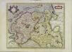
Emden & Oldenborch comit
1 Karte : Kupferdruck ; 32 x 41 cm Mercator; Hondius Henricus Hondius
Emden & Oldenborch comit
1 Karte : Kupferdruck ; 32 x 40 cm Mercator s.n.
![[Pas-Caarte van't Schager-Rack, De Sondt en de Belt. [Karte] Paskaartie van de Rievier de Elve. [...] [Nebenkarte], in: De Nieuwe Groote Vermeerderde Zee-Atlas ofte Water-Werelt, S. 19.](https://images-2.georeferencer.com/images/iiif/183997336220/full/,300/0/native.jpg)

