Maps of Ostfriesland

Königreich Hannover u. Herzogthum Oldenburg
1 : 380000 Aurich (Německo) Renner, Art. Frommann, Max.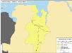
Straßen im Herzogtum Oldenburg 1848 (Auswahl)
Staat Oldenburg Straßennetz Kunz, Andreas ; Treiling, Thomas
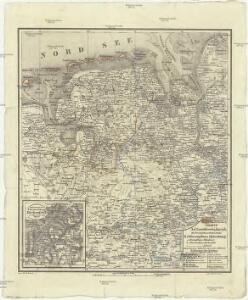
Westl. Theil des Kgr. Hannover (die Landdrosteien Aurich u. Osnabrück) und Grosszhzth. Oldenburg mit F. Lübeck u. F. Birkenfeld
1 : 1150000 E. Luther sc. Gotha : Perthes
Emden & Olden Borch Comit. [Karte], in: Gerardi Mercatoris Atlas, sive, Cosmographicae meditationes de fabrica mundi et fabricati figura, S. 337.
1 Karte aus Atlas Mercator, Gerhard Montanus, Petrus
Grossherzogthum Oldenburg und Gebiet der freien Stadt Bremen
Grosser Hand-Atlas über alle Theile der Erde in 170 Karten Meyer, J. Verlag des Bibliographischen Instituts
Westfalia cum diœcesi Bremensi
1 Karte : Kupferdruck ; 34 x 44 cm Mercator; Hondius sumptibus Henrici Hondij
Westfalia cum diœcesi Bremensi
1 Karte : Kupferdruck ; 34 x 44 cm Mercator; Hondius sumptibus Henrici Hondij
Westfalia cum diœcesi Bremensi
1 Karte : Kupferdruck ; 34 x 44 cm Mercator; Hondius sumptibus Henrici Hondij
Westfalia cum diœcesi Bremensi
1 Karte : Kupferdruck ; 34 x 44 cm Mercator s.n.
Tabula Frisiae orientalis
1 : 210000 Aurich (Německo) Coldewey, Ehrenreich Gerhard Allard, Abraham ex officina Ioh. Christoph. Homanni
Tabula Frisiae orientalis
1 : 210000 Aurich (Německo) Coldewey, Ehrenreich Gerhard Allard, Abraham ex officina Ioh. Christoph. Homanni

Oldenburg Comit. [Karte], in: Theatrum orbis terrarum, S. 213.
1 Karte aus Atlas Ortelius, Abraham Vrients, Jan Baptista
Emden & Oldenborch comit
1 Karte : Kupferdruck ; 32 x 41 cm Mercator; Hondius Henricus Hondius
Emden & Oldenborch comit
1 Karte : Kupferdruck ; 32 x 40 cm Mercator s.n.
Oost-Frise, ou Le Comté D'Embden subdivisé en ses principales Iurisditions. [Karte], in: Atlas nouveau, contenant toutes les parties du monde [...], Bd. 2, S. 93.
1 Karte aus Atlas Sanson, Nicolas Jaillot, Alexis Hubert und Mortier, Pieter
Frisia Orientalis [Karte] Rideriae Portionis [...] [Nebenkarte], in: Theatrum orbis terrarum, S. 201.
1 Karte aus Atlas Ortelius, Abraham Vrients, Jan Baptista
La Principauté d'Ost-Frise ou le Comté d'Embden : avec ses principales jurisdictions
1 : 210000 carte dessinée de nouveau par Tob. Conrad Lotter gravé par Georg Frederic Lotter Augsburg : Tob. Conrad Lotter
Episcopatvs Monasteriensis Pars Septentrionalis
1 : 290000 Mollova mapová sbírka Gigas, Johann Michael
Episcopatvs Monasteriensis Pars Septentrionalis
1 : 290000 Mollova mapová sbírka Gigas, Johann Michael
Comitatus Oldenburgici ac Delmenhorstani Sceptro Danico parentis Mappa specialissima Chorographica, novaq; recentissima
1 : 240000 Mollova mapová sbírka Rizzi Zannoni, Giovanni Antonio Seutter, Albrecht Carl
Tabula Frisiæ orientalis
1 Karte : Kupferdruck ; 47 x 56 cm Homann; Sanson; Coldewey; Allard; Emmius ex officina Ioh. Christoph: Homanni M. D
Tabula Frisiæ orientalis
1 Karte : Kupferdruck ; 47 x 56 cm Homann; Sanson; Coldewey; Allard; Emmius ex officina Ioh. Christoph: Homanni M. D
Tabula Frisiæ orientalis
1 Karte : Kupferdruck ; 47 x 56 cm Homann; Sanson; Coldewey; Allard; Emmius ex officina Ioh. Christoph: Homanni M. D
Typus Frisiae Orientalis. [Karte], in: Gerardi Mercatoris et I. Hondii Newer Atlas, oder, Grosses Weltbuch, Bd. 1, S. 149.
1 Karte aus Atlas Mercator, Gerhard und Hondius, Jodocus Jansson, Jan
Typus Frisiae Orientalis. [Karte] Rideriae Portionis [...] [Nebenkarte], in: Novus Atlas, das ist, Weltbeschreibung, Bd. 1, S. 126.
1 Karte aus Atlas Blaeu, Joan Blaeu, Willem Janszoon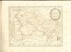

Basse Partie De L'Evesché De Munster, Et Le Comté De Benthem. [Karte], in: Atlas nouveau, contenant toutes les parties du monde [...], Bd. 1, S. 307.
1 Karte aus Atlas Sanson, Nicolas Jaillot, Alexis Hubert und Mortier, Pieter
L'Eveché de Munster Le Comté de Bentheim Tecklenbourg Stenford Lingen, Diepholtz Delmenhorst, Ritberg &c.
1 : 420000 Mollova mapová sbírka Le Rouge, Georges-Louis Le Rouge, Georges-Louis