Maps of Landkreis Diepholz

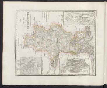
Grossherzogthum Oldenburg und Gebiet der freien Stadt Bremen
Grosser Hand-Atlas über alle Theile der Erde in 170 Karten Meyer, J. Verlag des Bibliographischen Instituts
Straßen im Herzogtum Oldenburg 1848 (Auswahl)
Staat Oldenburg Straßennetz Kunz, Andreas ; Treiling, Thomas
Westl. Theil des Kgr. Hannover (die Landdrosteien Aurich u. Osnabrück) und Grosszhzth. Oldenburg mit F. Lübeck u. F. Birkenfeld
1 : 1150000 E. Luther sc. Gotha : Perthes
Königreich Hannover u. Herzogthum Oldenburg
1 : 380000 Aurich (Německo) Renner, Art. Frommann, Max.
Westfalia cum diœcesi Bremensi
1 Karte : Kupferdruck ; 34 x 44 cm Mercator; Hondius sumptibus Henrici Hondij
Westfalia cum diœcesi Bremensi
1 Karte : Kupferdruck ; 34 x 44 cm Mercator; Hondius sumptibus Henrici Hondij
Westfalia cum diœcesi Bremensi
1 Karte : Kupferdruck ; 34 x 44 cm Mercator; Hondius sumptibus Henrici Hondij
Westfalia cum diœcesi Bremensi
1 Karte : Kupferdruck ; 34 x 44 cm Mercator s.n.
Oldenburg Comit. [Karte], in: Theatrum orbis terrarum, S. 213.
1 Karte aus Atlas Ortelius, Abraham Vrients, Jan Baptista
Emden & Olden Borch Comit. [Karte], in: Gerardi Mercatoris Atlas, sive, Cosmographicae meditationes de fabrica mundi et fabricati figura, S. 337.
1 Karte aus Atlas Mercator, Gerhard Montanus, Petrus

Comitatus Oldenburgici ac Delmenhorstani Sceptro Danico parentis Mappa specialissima Chorographica, novaq; recentissima
1 : 240000 Mollova mapová sbírka Rizzi Zannoni, Giovanni Antonio Seutter, Albrecht Carl
Oldenbvrg Comitatvs.
1 : 190000 Mollova mapová sbírka Aveele, Johannes van den
Oldenbvrg Comitatvs
1 : 190000 Mollova mapová sbírka Aveele, Johannes van den

Le Theatre de Bellone :
Mollova mapová sbírka Schenk, Pieter Braakman, Adriaan
Oldenburg Comitatus [Karte], in: Novus atlas absolutissimus, Bd. 2, S. 109.
1 Karte aus Atlas Janssonius Offizin
Episcopatvs Monasteriensis Pars Septentrionalis
1 : 290000 Mollova mapová sbírka Gigas, Johann Michael
Episcopatvs Monasteriensis Pars Septentrionalis
1 : 290000 Mollova mapová sbírka Gigas, Johann Michael
Oldenbvrg Comit.
1 : 250000 Mollova mapová sbírka Michaelis, Laurentius Plantin, Christoph
Oldenburg Comitatus [Karte], in: Novus Atlas, das ist, Weltbeschreibung, Bd. 1, S. 123.
1 Karte aus Atlas Blaeu, Joan Blaeu, Willem Janszoon
Bremen 44, uit: [W. Liebenow's Special-Karte von Mittel-Europa]
1 : 300000 titelvariant: W. Liebenow's Mittel-Europa; Annotatie: Titel boven de bladen: W. Liebenow's Mittel-Europa Johannes Wilhelm Liebenow 1822-1897 Hannover : Hermann Oppermann
Oldenburg Comitatus [Karte], in: Le théâtre du monde, ou, Nouvel atlas contenant les chartes et descriptions de tous les païs de la terre, Bd. 1, S. 154.
1 Karte aus Atlas Blaeu, Willem Janszoon und Blaeu, Joan Blaeu, Willem Janszoon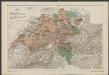
Oldenburg Comitatus [Karte], in: Gerardi Mercatoris et I. Hondii Newer Atlas, oder, Grosses Weltbuch, Bd. 1, S. 155.
1 Karte aus Atlas Mercator, Gerhard und Hondius, Jodocus Jansson, Jan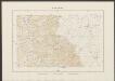
Oldenburg Comitatus [Karte], in: Theatrum orbis terrarum, sive, Atlas novus, Bd. 1, S. 200.
1 Karte aus Atlas Blaeu, Joan Blaeu, Willem Janszoon
OLDENBVRG | COMITATVS.
E. Sijmonsz. Hamersveldt sculp. [Amsterdam : Joan Blaeu]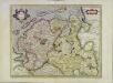
Emden & Oldenborch comit
1 Karte : Kupferdruck ; 32 x 41 cm Mercator; Hondius Henricus Hondius
Emden & Oldenborch comit
1 Karte : Kupferdruck ; 32 x 40 cm Mercator s.n.
L'Eveché de Munster Le Comté de Bentheim Tecklenbourg Stenford Lingen, Diepholtz Delmenhorst, Ritberg &c.
1 : 420000 Mollova mapová sbírka Le Rouge, Georges-Louis Le Rouge, Georges-Louis