Maps of Ostfriesland

Westl. Theil des Kgr. Hannover (die Landdrosteien Aurich u. Osnabrück) und Grosszhzth. Oldenburg mit F. Lübeck u. F. Birkenfeld
1 : 1150000 E. Luther sc. Gotha : Perthes
Straßen im Herzogtum Oldenburg 1848 (Auswahl)
Staat Oldenburg Straßennetz Kunz, Andreas ; Treiling, Thomas
Westphaliae totivs, finitimarvmqve regionvm accvrata descriptio
1 Karte : Kupferdruck ; 33 x 48 cm Sgrooten; Ortelius s.n.
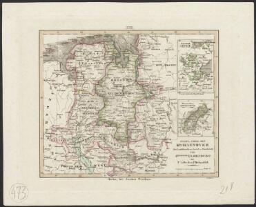
Königreich Hannover u. Herzogthum Oldenburg
1 : 380000 Aurich (Německo) Renner, Art. Frommann, Max.
Episcopatus Bremensis cum Adiacentibus. [Karte], in: Novus atlas absolutissimus, Bd. 2, S. 103.
1 Karte aus Atlas Janssonius Offizin
Westfalia Cum Dioecesi Bremensi. [Karte], in: Gerardi Mercatoris Atlas, sive, Cosmographicae meditationes de fabrica mundi et fabricati figura, S. 340.
1 Karte aus Atlas Mercator, Gerhard Montanus, Petrus
Westfalia Cum Dioecesi Bremensi. [Karte], in: Gerardi Mercatoris et I. Hondii Newer Atlas, oder, Grosses Weltbuch, Bd. 1, S. 158.
1 Karte aus Atlas Mercator, Gerhard und Hondius, Jodocus Jansson, Jan
Grossherzogthum Oldenburg und Gebiet der freien Stadt Bremen
Grosser Hand-Atlas über alle Theile der Erde in 170 Karten Meyer, J. Verlag des Bibliographischen Instituts

Episcopatus Monasteriensis et Osnabrugensis nec non Comitatuum Bentheim Teckelenburg Stanford Lingen Diepholt Delmenhorst Ritberg etc. Tabula
1 : 410000 Mollova mapová sbírka Danckerts, Justus Danckerts, Justus

Westfalia cum diœcesi Bremensi
1 Karte : Kupferdruck ; 34 x 44 cm Mercator; Hondius sumptibus Henrici Hondij
Westfalia cum diœcesi Bremensi
1 Karte : Kupferdruck ; 34 x 44 cm Mercator; Hondius sumptibus Henrici Hondij
Westfalia cum diœcesi Bremensi
1 Karte : Kupferdruck ; 34 x 44 cm Mercator; Hondius sumptibus Henrici Hondij
Westfalia cum diœcesi Bremensi
1 Karte : Kupferdruck ; 34 x 44 cm Mercator s.n.
Episcopatuum Monasteriensis et Osnabrugensis ut et comitatum Bentheim, Teclenburg, Stenford, Lingen, Diepholt, Delmenhorst, Rietberg etc. etc. novissima et accuratissima designatio
1 : 330000 cura et sumptibus Tobiae Conradi Lotter Tob. Con. Lotter sculp. Aug. Vind : Tob. Conr. Lotter
Territorium Seculare Episcopatvs Monasterii Mvnster Germanis dicti
1 : 420000 Mollova mapová sbírka Homann, Johann Baptist Homann, Johann Baptista - dědici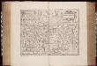
Monasteriensis episcopatus / [Joannes Janssonius]
1 : 450000 Annotatie: Rechtsboven: XXVI; Verschenen in: The English atlas volume III ... - Amsterdam : J. Jansonius a Waesberg and S. Swart, 1683; 1e staat: Amstelodami : apud Ioannem Ianssonium, [1630]; Origineel is Blad 76 in atlas factice; Annotatie geografische gegevens: West boven Janssonius, Joannes (jr.) (1588-1664) [Amsterdam : J. Jansonius van Waesberge etc.]
Monasteriensis Episcopatus. [Karte], in: Novus atlas absolutissimus, Bd. 2, S. 118.
1 Karte aus Atlas Janssonius Offizin
Monasteriensis Episcopatus. [Karte], in: Le théâtre du monde, ou, Nouvel atlas contenant les chartes et descriptions de tous les païs de la terre, Bd. 1, S. 160.
1 Karte aus Atlas Blaeu, Willem Janszoon und Blaeu, Joan Blaeu, Willem Janszoon
Monasteriensis Episcopatus. [Karte], in: Theatrum orbis terrarum, sive, Atlas novus, Bd. 1, S. 209.
1 Karte aus Atlas Blaeu, Joan Blaeu, Willem Janszoon
Monasteriensis Episcopatus. [Karte], in: Novus Atlas, das ist, Weltbeschreibung, Bd. 1, S. 129.
1 Karte aus Atlas Blaeu, Joan Blaeu, Willem Janszoon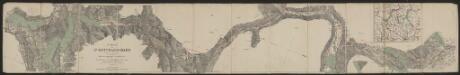
Monasteriensis Episcopatus. [Karte], in: Gerardi Mercatoris et I. Hondii Newer Atlas, oder, Grosses Weltbuch, Bd. 1, S. 164.
1 Karte aus Atlas Mercator, Gerhard und Hondius, Jodocus Jansson, Jan
Basse Partie De L'Evesché De Munster, Et Le Comté De Benthem. [Karte], in: Atlas nouveau, contenant toutes les parties du monde [...], Bd. 1, S. 307.
1 Karte aus Atlas Sanson, Nicolas Jaillot, Alexis Hubert und Mortier, Pieter
L'Eveché de Munster Le Comté de Bentheim Tecklenbourg Stenford Lingen, Diepholtz Delmenhorst, Ritberg &c.
1 : 420000 Mollova mapová sbírka Le Rouge, Georges-Louis Le Rouge, Georges-Louis
Basse Partie de l'Evesché de Munster, et le Comté de Benthem
1 : 300000 Mollova mapová sbírka Sanson, Guillaume Mortier, Pierre

Carte Nouvelle de l'Eveché de Munster
1 : 180000 Mollova mapová sbírka Grancourt
Emden & Olden Borch Comit. [Karte], in: Gerardi Mercatoris Atlas, sive, Cosmographicae meditationes de fabrica mundi et fabricati figura, S. 337.
1 Karte aus Atlas Mercator, Gerhard Montanus, Petrus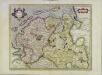
Emden & Oldenborch comit
1 Karte : Kupferdruck ; 32 x 41 cm Mercator; Hondius Henricus Hondius