Maps of Nordfriesland
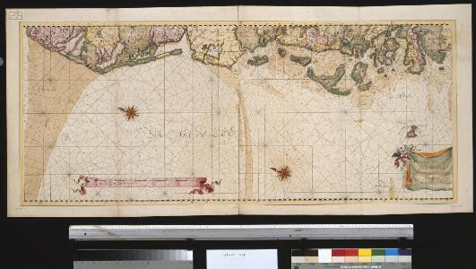
De westkust van Jutland van Beusem tot aan 't Jutsche Riff
Denmark Johannes van Keulen
Tondern 10, uit: Special-Karte von Mittel-Europa / nach amtlichen Quellen bearbeitet von W. Liebenow
1 : 300000 titelvariant: W. Liebenow's Mittel-Europa; Annotatie: Titel boven de bladen: W. Liebenow's Mittel-Europa Johannes Wilhelm Liebenow 1822-1897 Frankfurt a. M. : Ludwig Ravenstein
Tönning 20, uit: Special-Karte von Mittel-Europa / nach amtlichen Quellen bearbeitet von W. Liebenow
1 : 300000 titelvariant: W. Liebenow's Mittel-Europa; Annotatie: Titel boven de bladen: W. Liebenow's Mittel-Europa Johannes Wilhelm Liebenow 1822-1897 Frankfurt a. M. : Ludwig Ravenstein
Tönning 20, uit: [W. Liebenow's Special-Karte von Mittel-Europa]
1 : 300000 titelvariant: W. Liebenow's Mittel-Europa; Annotatie: Titel boven de bladen: W. Liebenow's Mittel-Europa Johannes Wilhelm Liebenow 1822-1897 Hannover : Hermann Oppermann
Ringkjöbing 1, uit: Special-Karte von Mittel-Europa / nach amtlichen Quellen bearbeitet von W. Liebenow
1 : 300000 titelvariant: W. Liebenow's Mittel-Europa; Annotatie: Titel boven de bladen: W. Liebenow's Mittel-Europa Johannes Wilhelm Liebenow 1822-1897 Frankfurt a. M. : Ludwig Ravenstein
[left] FRISIA BOREALIS | IN DVCATV SLESWICENSI | sive FRISIA CIMBRICA | Anno 1651. [right] FRISIA BOREALIS | IN DVCATV SLESWICENSI | Anno 1240. | Frisia Cimbrica Antiqua.
Matthias & Nicolao Peters | Goldtschmide gbr. Husum. sculps. [Amsterdam : Joan Blaeu]
Geologische Karte der Insel Sylt und ihrer nächsten Umgebungen / geologisch bearb. durch L. Meyn
1 : 100000 Annotatie: Geeft ook waterdiepten en stroomrichtingen aan; Met aantekening in potlood boven de titel Berlin : [Königl. Preussische geologische Landesanstalt]
PARS OCCIDENTALIS | PRÆFECTVRÆ | HADERSLEBEN | cum adjacentibus | RIPEN et LOHMCLOSTER | PRÆFECTVRIS.
Matthias Vnd Clauss Petersen | Goldtschmide gebr. Husumens. sculps. [Amsterdam : Joan Blaeu]
Nordsee
1 : 50000 Cuxhaven (Německo) Reichs-Marine-Amt
5. Hvidding. (Germany)
1 : 100000 Reichsamt fur Landesaufnahme
Composite: 5. Hvidding. (Germany)
1 : 100000 Reichsamt fur Landesaufnahme
Composite: 79a. Helgoland. (Germany)
1 : 100000 Reichsamt fur Landesaufnahme
PRÆFECTVRÆ | TONDERANÆ | ORA MARITIMA
Matthias & Nicolaus Peters | Goldtschmide gebr. Hus. | sculps. [Amsterdam : Joan Blaeu]
79. Eider-Mundung. (Germany)
1 : 100000 Reichsamt fur Landesaufnahme
36. Fohr. (Germany)
1 : 100000 Reichsamt fur Landesaufnahme
Composite: 36. Fohr. (Germany)
1 : 100000 Reichsamt fur Landesaufnahme
11. Rom. (Germany)
1 : 100000 Reichsamt fur Landesaufnahme
21. Hoyer. (Germany)
1 : 100000 Reichsamt fur Landesaufnahme
55. Garding. (Germany)
1 : 100000 Reichsamt fur Landesaufnahme
Composite: 11. Rom. (Germany)
1 : 100000 Reichsamt fur Landesaufnahme
Composite: 55. Garding. (Germany)
1 : 100000 Reichsamt fur Landesaufnahme
Composite: 21. Hoyer. (Germany)
1 : 100000 Reichsamt fur Landesaufnahme
Composite: 20. Westerland. (Germany)
1 : 100000 Reichsamt fur Landesaufnahme
Composite: 79. Eider-Mundung. (Germany)
1 : 100000 Reichsamt fur Landesaufnahme
20. Westerland. (Germany)
1 : 100000 Reichsamt fur Landesaufnahme
Composite: 22. Tondern. (Germany)
1 : 100000 Reichsamt fur Landesaufnahme
79a. Helgoland. (Germany)
1 : 100000 Reichsamt fur Landesaufnahme
Meßtischblatt 735 : Cuxhaven, 1897
1 : 250000 Cuxhaven. - Aufn. 1878, hrsg. 1880, Nachtrag Eisenbahn 1897. - 1:25000. - [Berlin]: Reichsamt für Landesaufnahme, 1897. - 1 Kt.
Meßtischblatt 2117 : Altenwalde, 1941
1 : 250000 Altenwalde. - Aufn. 1878, hrsg. 1880, letzte Nachtr. 1926. - 1:25000. - [Berlin]: Reichsamt für Landesaufnahme, 1941. - 1 Kt.