Maps of Schleswig-Holstein

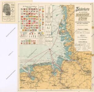
Bäderkarte der deutschen Nordsee - Küste

Geographische Vorstellung der jämerlichen Wasser-Flutt in Nieder-Teutschland
1 : 590000 Mollova mapová sbírka Homann, Johann Baptist Homann, Johann Baptista
Nieuwe Caerte waerinne vertoont wordt de gantsche Vaert van Amsterdam over de Watten tot de stadt Hamborch toe. [Karte, Teil 2], in: Gerardi Mercatoris et I. Hondii Newer Atlas, oder, Grosses Weltbuch, Bd. 1, S. 152.
1 Karte aus Atlas Mercator, Gerhard und Hondius, Jodocus Jansson, Jan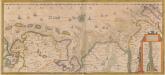
Nieuwe Caerte waerinne vertoont wordt de gantsche Vaert van Amsterdam over de Watten tot de stadt Hamborch toe. [Karte, Teil 2], in: Novus atlas absolutissimus, Bd. 2, S. 95.
1 Karte aus Atlas Janssonius Offizin
Übersichtskarte von Mittel - Europa

Holsatiae Tabula Generalis
1 : 310000 Mollova mapová sbírka Wit, Frederik de Mortier, Pierre
Ducatus Holsatiae Descriptio Novissima
1 : 490000 Mollova mapová sbírka Visscher, Nicolaes Visscher, Nicolaus
Ducatus Holsatiae Descriptio Novissima
1 : 490000 Mollova mapová sbírka Visscher, Nicolaes Jansz. Visscher, Nicolaus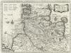
Dvcatvs Holsatiae Nova Tabvla
1 : 850000 Mollova mapová sbírka Merian, Matthaeus Merian, Matthäus - dědici
Hamburg, Wilhelmshaven, Schleswig
1 : 750000 Hamburk (Německo : oblast) Cronenberg, Eduard von K. u. k. Militärgeographisches Institut
Hamburg, Wilhelmshaven, Schleswig
1 : 750000 Hamburk (Německo : oblast) K. k. militär-geographisches Institut
Spezial - Karte von Schleswig - Holstein...

NOVA & ACCVRATA | DVCATVVM | SLESVICI | ET | HOLSATIÆ | TABVLA.
Matthias und Nicolaus Pet. Goldtschmide gebr. | Hus. Cimb. sculps. [Amsterdam : Joan Blaeu]
[Pas-Caarte van't Schager-Rack, De Sondt en de Belt. [Karte] Paskaartie van de Rievier de Elve. [...] [Nebenkarte], in: De Nieuwe Groote Vermeerderde Zee-Atlas ofte Water-Werelt, S. 19.
1 Karte aus Atlas Doncker, Hendrick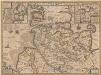
Ducatus Holsatiae Nova Tabula [Karte] Alluvies propè Detzbul [...] [Nebenkarte] Tabula Barmerensis [...] [Nebenkarte], in: Novus Atlas, das ist, Weltbeschreibung, Bd. 1, S. 114.
1 Karte aus Atlas Blaeu, Joan Blaeu, Willem Janszoon
Ducatus Holsatiae Nova Tabula [Karte] Alluvies propè Detzbul [...] [Nebenkarte] Tabula Barmerensis [...] [Nebenkarte], in: Le théâtre du monde, ou, Nouvel atlas contenant les chartes et descriptions de tous les païs de la terre, Bd. 1, S. 143.
1 Karte aus Atlas Blaeu, Willem Janszoon und Blaeu, Joan Blaeu, Willem Janszoon
Ducatus Holsatiae Nova Tabula [Karte] Alluvies propè Detzbul [...] [Nebenkarte] Tabula Barmerensis [...] [Nebenkarte] , in: Novus atlas absolutissimus, Bd. 1, S. 143.
1 Karte aus Atlas Janssonius Offizin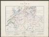
Ducatus Holsatiae Nova Tabula [Karte] Alluvies propè Detzbul [...] [Nebenkarte] Tabula Barmerensis [...] [Nebenkarte] , in: Gerardi Mercatoris et I. Hondii Newer Atlas, oder, Grosses Weltbuch, Bd. 1, S. 109.
1 Karte aus Atlas Mercator, Gerhard und Hondius, Jodocus Jansson, Jan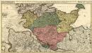
Holsatiae Ducatus, Vernaculè Das Hertzogtum Holstein
1 : 310000 Mollova mapová sbírka Visscher, Nicolaes Schenk, Peter II
Holsatiae Descriptio. [Karte], in: Theatrum orbis terrarum, S. 208.
1 Karte aus Atlas Ortelius, Abraham Vrients, Jan Baptista
Ducatus Bremae & Ferdae maximaeque partis fluminis Visurgis
1 : 326500 Brémy (Německo : spolková země) Wit, Frederick de R. & J. Ottens
DUCATUS BREMAE & FERDAE Maximaeque partis FLUMINIS VISURGIS
1 : 340000 Brémy (Německo : spolková země) Wit, Frederick de Frederic de Wit
Ducatus Bremae & Ferdae maximaeque partis fluminis Visurgis
1 : 326500 Brémy (Německo : spolková země) Wit, Frederick de I. Covens et C. Mortier
Westfalia Cum Dioecesi Bremensi. [Karte], in: Gerardi Mercatoris et I. Hondii Newer Atlas, oder, Grosses Weltbuch, Bd. 1, S. 158.
1 Karte aus Atlas Mercator, Gerhard und Hondius, Jodocus Jansson, Jan
Westfalia Cum Dioecesi Bremensi. [Karte], in: Gerardi Mercatoris Atlas, sive, Cosmographicae meditationes de fabrica mundi et fabricati figura, S. 340.
1 Karte aus Atlas Mercator, Gerhard Montanus, Petrus


Episcopatus Bremensis cum Adiacentibus. [Karte], in: Novus atlas absolutissimus, Bd. 2, S. 103.
1 Karte aus Atlas Janssonius Offizin
Holsatiae Descriptio. [Karte], in: Theatrum orbis terrarum, S. 120.
1 Karte aus Atlas Ortelius, Abraham