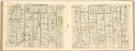
Maps of Lincolnshire

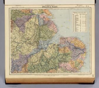
Watershed map England, Wales 4.
1 : 760320 Letts, Son & Co.
England III.
1 : 765000 Society for the Diffusion of Useful Knowledge (Great Britain)
England
1 : 778000 under the superintendence of the Society for the Diffusion of Useful Knowledge J. & C. Walker sculpt. London : Baldwin and Cradock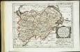
Des Königreichs England westlicher Theil, oder Hereford Shire, Worcester Sh, Warwick Shire
1 Karte : Kupferdruck ; 19 x 25 cm Reilly F. J. J. von Reilly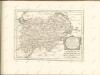

delineation of the strata of England and Wales, with part of Scotland
1 : 320000 Blatt 8 Smith, William Cary
Lincolnia Comitatus Anglis Lyncolne Shire. [Karte], in: Novus atlas absolutissimus, Bd. 7, S. 323.
1 Karte aus Atlas Janssonius Offizin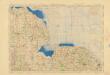
Ordnance Survey of England and Wales (Aeronautical map)
Great Britain. War Office. General Staff. Geographical Section [London] : [Air Ministry],
Lincolnia Comitatus anglis Lyncolne Shire
1 : 580000 [Amstelodami] : [apud Joannem Janssonium]
Lincolnia Comitatus. Anglis Lincoln-Shire. [Karte], in: Theatrum orbis terrarum, sive, Atlas novus, Bd. 4, S. 335.
1 Karte aus Atlas Blaeu, Joan Blaeu, Willem Janszoon
Lincolnia Comitatus. Anglis Lincoln-Shire. [Karte], in: Theatrum orbis terrarum, sive, Atlas novus, Bd. 4, S. 335.
1 Karte aus Atlas Blaeu, Joan Blaeu, Willem Janszoon
Lincolnia Comitatus. Anglis Lincoln-Shire. [Karte], in: Le théâtre du monde, ou, Nouvel atlas contenant les chartes et descriptions de tous les païs de la terre, Bd. 4, S. 293.
1 Karte aus Atlas Blaeu, Willem Janszoon und Blaeu, Joan Blaeu, Willem Janszoon
LINCOLNIA | COMITATVS. Anglis | LINCOLN-SHIRE.
[Amsterdam : Joan Blaeu]
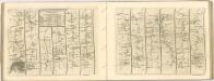
Sheet 6 Eastern Counties (N.), uit: Maps of England & Wales : scale 4 miles to 1 inch / Ordnance Survey
1 : 253440 titelvariant: Maps of England and Wales; Annotatie: Titel op cassette; Met bladoverzicht op de achterzijde van de cassette; Annotatie geografische gegevens: Hoogtelijneninterval 200 ft Ordnance Survey, United Kingdom Southampton : Ordnance Survey Office
NORTHAMTON, Bedfordiae, Cantabrigiae,, Huntingdoniae et Rutlandiae Comitatum
This is a map of Northamptonshire, Bedfordfordshire, Cambridgeshire, Huntingdonshire and Rutland by Christopher Saxton, dating from 1576. It forms part of an atlas that belonged to William Cecil Lord Burghley, Elizabeth I’s Secretary of State. Burghley used this atlas to illustrate domestic matters. This map is actually a proof copy of one which forms part of Christopher Saxton’s Atlas of England and Wales. This atlas was first published as a whole in 1579. It consists of 35 coloured maps depicting the counties of England and Wales. The atlas is of great significance to British cartography as it set a standard of cartographic representation in Britain and the maps remained the basis for English county mapping, with few exceptions, until after 1750. During the reign of Elizabeth I, map use became more common, with many government matters referring to increasingly accurate maps with consistent scales and symbols, made possible by advances in surveying techniques. Illustrating the increasing use of maps in government matters, Lord Burghley, who had been determined to have England and Wales mapped in detail from the 1550s, selected the cartographer Christopher Saxton to produce a detailed and consistent survey of the country. The financier of the project was Thomas Seckford, Master of Requests at the Court of Elizabeth I, whose arms appear, along with the royal crest, on each map.Lord Burghley has added information to this map, adding place names and a park, symbolized by a depiction of fenced enclosure. Knowledge of the location of parks in an area was an important one when considering defence of the country as they could funtion as a service area for troops in need of rest. Saxton, Christopher William Cecil, Lord Burghley
England and Wales 1:253,440
Ordnance Survey
LINCOLNIAE NOTINGHHAMIAQUE Comitatum
This is a map of Lincolnshire and Nottinghamshire by Christopher Saxton, dating from 1576. It forms part of an atlas that belonged to William Cecil Lord Burghley, Elizabeth I’s Secretary of State. Lord Burghley used this atlas to illustrate domestic matters. This map is actually a proof copy of one which forms part of Christopher Saxton’s Atlas of England and Wales. This atlas was first published as a whole in 1579. It consists of 35 coloured maps depicting the counties of England and Wales. The atlas is of great significance to British cartography as it set a standard of cartographic representation in Britain and the maps remained the basis for English county mapping, with few exceptions, until after 1750. During the reign of Elizabeth I map use became more common, with many government matters referring to increasingly accurate maps with consistent scales and symbols, made possible by advances in surveying techniques. Illustrating the increasing used of maps in government matters, Lord Burghley, who had been determined to have England and Wales mapped in detail from the 1550s, selected the cartographer Christopher Saxton to produce a detailed and consistent survey of the country. The financier of the project was Thomas Seckford Master of Requests at the Court of Elizabeth I, whose arms appear, along with the royal crest, on each map. Burghley has annotated this map, adding place names adjacent to the tributaries of the Humber. A battle is depicted at the mouth of the Humber, perhaps reflecting the military importance of Hull which was heavily fortified by Henry VIII and then repaired during the Elizabethan period in readiness for the threatened Spanish invasion. The map was engraved by Remigius Hogenbergius, one of a team of seven English and Flemish engravers employed to produce the copper plates for the atlas. Saxton, Christopher Hogenbergius, Remigius
NORTHANTON Bedfordiae Cantabrigiae, Huntingdoniae et Rutlandiae Comitatum
This map of Northamptonshire and the neighbouring counties of Bedfordshire, Cambridgeshire, Huntingdonshire and Rutland is from the 1583 edition of the Saxton atlas of England and Wales.This atlas was first published as a whole in 1579. It consists of 35 coloured maps depicting the counties of England and Wales. The atlas is of great significance to British cartography as it set a standard of cartographic representation in Britain and the maps remained the basis for English county mapping, with few exceptions, until after 1750. During the reign of Elizabeth I map use became more common, with many government matters referring to increasingly accurate maps with consistent scales and symbols, made possible by advances in surveying techniques. Illustrating the increasing used of maps in government matters, Lord Burghley, Elizabeth I’s Secretary of State, who had been determined to have England and Wales mapped in detail from the 1550s, selected the cartographer Christopher Saxton to produce a detailed and consistent survey of the country. The financier of the project was Thomas Seckford Master of Requests at the Court of Elizabeth I, whose arms appear, along with the royal crest, on each map. Saxton, Christopher Ryther, Augustine
LINCOLNIAE NOTINGHAMMIAE Comitatuu
This map of Lincolnshire and Nottinghamshire is from the 1583 edition of the Saxton atlas of England and Wales. This atlas was first published as a whole in 1579. It consists of 35 coloured maps depicting the counties of England and Wales. The atlas is of great significance to British cartography as it set a standard of cartographic representation in Britain and the maps remained the basis for English county mapping, with few exceptions, until after 1750. During the reign of Elizabeth I map use became more common, with many government matters referring to increasingly accurate maps with consistent scales and symbols, made possible by advances in surveying techniques. Illustrating the increasing used of maps in government matters, Lord Burghley, Elizabeth I’s Secretary of State, who had been determined to have England and Wales mapped in detail from the 1550s, selected the cartographer Christopher Saxton to produce a detailed and consistent survey of the country. The financier of the project was Thomas Seckford Master of Requests at the Court of Elizabeth I, whose arms appear, along with the royal crest, on each map. A decorative scale bar holds Saxton’s name and also that of the engraver of this map, engraver Remigius Hogenberg, one of seven English and Flemish engravers employed to produce the copper plates for the atlas. Relief, in the form of uniform rounded representations of hills, is the main topographical feature presented in the maps. Rather than provide a scientific representation of relative relief these give a general impression of the lie of the land. Settlements and notable buildings are also recorded pictorially; a small building with a spire represents a village, while more important towns, such as Hereford are indicated by groups of buildings. Saxton, Christopher Ryther, Augustine
Cambridgshire : described with the deuision of the hundreds, the townes situation, with the armes of the colleges of that famous vniuersiti and also the armes of all such princes and noblemen as haue heertofore borne the honorable tytles & dignities of the Earldome of Cambridge
1 : 109890 Speed, John, 1552?-1629 J. Sudbury and G. Humbell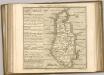

Comitatus Northantonensis vernacule Northampton Shire. [Karte], in: Novus atlas absolutissimus, Bd. 7, S. 309.
1 Karte aus Atlas Janssonius Offizin
Ordnance Survey of England and Wales (Sheet 9), East Anglia
Ordnance Survey, Great Britain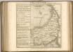

Nortfolcia; Norfolke. [Karte], in: Theatrum orbis terrarum, sive, Atlas novus, Bd. 4, S. 296.
1 Karte aus Atlas Blaeu, Joan Blaeu, Willem Janszoon
Nortfolcia; Norfolke. [Karte], in: Theatrum orbis terrarum, sive, Atlas novus, Bd. 4, S. 296.
1 Karte aus Atlas Blaeu, Joan Blaeu, Willem Janszoon
Ordnance Survey of England and Wales (Aeronautical map)
Great Britain. War Office. General Staff. Geographical Section [London] : [Air Ministry],