Maps of Northamptonshire

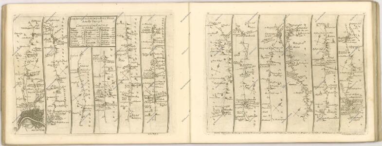
DRAKE'S MAP OF THE LONDON AND BIRMINGHAM RAILWAY and DRAKE'S MAP OF THE GRAND JUNCTION RAILWAY
The first map shows the London and Birmingham Railway, with an illustrated view of Euston Station at top right. The second shows the Grand Junction Railway (which connected Birmingham, Manchester and Liverpool) with an illustration of a train used on the line along the top. The titles of both maps appear above the relevant plans, with county boundaries outlined in colour. A level section of the railway line is given in a panel below each plan. Wollace, J. B.
England and Wales 1:253,440
Ordnance Survey
Comitatus Northantonensis vernacule Northampton Shire. [Karte], in: Novus atlas absolutissimus, Bd. 7, S. 309.
1 Karte aus Atlas Janssonius Offizin
Comitatus Northantonensis; Vernacule Northamton Shire. [Karte], in: Theatrum orbis terrarum, sive, Atlas novus, Bd. 4, S. 320.
1 Karte aus Atlas Blaeu, Joan Blaeu, Willem Janszoon
Comitatus Northantonensis; Vernacule Northampton Shire. [Karte], in: Le théâtre du monde, ou, Nouvel atlas contenant les chartes et descriptions de tous les païs de la terre, Bd. 4, S. 280.
1 Karte aus Atlas Blaeu, Willem Janszoon und Blaeu, Joan Blaeu, Willem Janszoon
Comitatus Northantonensis; Vernacule Northamton Shire. [Karte], in: Theatrum orbis terrarum, sive, Atlas novus, Bd. 4, S. 320.
1 Karte aus Atlas Blaeu, Joan Blaeu, Willem Janszoon
Comitatus Northantonensis vernacule Northamton Shire
1 : 220000 [Amstelodami] : [apud Joannem Janssonium]
A new travelling map of the country round London, 1
1 Blatt : 49 x 61 cm J. Andrews & A. Drury

NORTHAMTON, Bedfordiae, Cantabrigiae,, Huntingdoniae et Rutlandiae Comitatum
This is a map of Northamptonshire, Bedfordfordshire, Cambridgeshire, Huntingdonshire and Rutland by Christopher Saxton, dating from 1576. It forms part of an atlas that belonged to William Cecil Lord Burghley, Elizabeth I’s Secretary of State. Burghley used this atlas to illustrate domestic matters. This map is actually a proof copy of one which forms part of Christopher Saxton’s Atlas of England and Wales. This atlas was first published as a whole in 1579. It consists of 35 coloured maps depicting the counties of England and Wales. The atlas is of great significance to British cartography as it set a standard of cartographic representation in Britain and the maps remained the basis for English county mapping, with few exceptions, until after 1750. During the reign of Elizabeth I, map use became more common, with many government matters referring to increasingly accurate maps with consistent scales and symbols, made possible by advances in surveying techniques. Illustrating the increasing use of maps in government matters, Lord Burghley, who had been determined to have England and Wales mapped in detail from the 1550s, selected the cartographer Christopher Saxton to produce a detailed and consistent survey of the country. The financier of the project was Thomas Seckford, Master of Requests at the Court of Elizabeth I, whose arms appear, along with the royal crest, on each map.Lord Burghley has added information to this map, adding place names and a park, symbolized by a depiction of fenced enclosure. Knowledge of the location of parks in an area was an important one when considering defence of the country as they could funtion as a service area for troops in need of rest. Saxton, Christopher William Cecil, Lord Burghley
NORTHANTON Bedfordiae Cantabrigiae, Huntingdoniae et Rutlandiae Comitatum
This map of Northamptonshire and the neighbouring counties of Bedfordshire, Cambridgeshire, Huntingdonshire and Rutland is from the 1583 edition of the Saxton atlas of England and Wales.This atlas was first published as a whole in 1579. It consists of 35 coloured maps depicting the counties of England and Wales. The atlas is of great significance to British cartography as it set a standard of cartographic representation in Britain and the maps remained the basis for English county mapping, with few exceptions, until after 1750. During the reign of Elizabeth I map use became more common, with many government matters referring to increasingly accurate maps with consistent scales and symbols, made possible by advances in surveying techniques. Illustrating the increasing used of maps in government matters, Lord Burghley, Elizabeth I’s Secretary of State, who had been determined to have England and Wales mapped in detail from the 1550s, selected the cartographer Christopher Saxton to produce a detailed and consistent survey of the country. The financier of the project was Thomas Seckford Master of Requests at the Court of Elizabeth I, whose arms appear, along with the royal crest, on each map. Saxton, Christopher Ryther, Augustine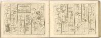

WARWIC LECESTRIAQUE Comitat.
This is a map of Warwickshire and Leicestershire by Christopher Saxton dating from 1576. It forms part of an atlas that belonged to William Cecil Lord Burghley, Elizabeth I’s Secretary of State. Burghley used this atlas to illustrate domestic matters. This map is actually a proof copy of one which forms part of Christopher Saxton’s Atlas of England and Wales. This atlas was first published as a whole in 1579. It consists of 35 coloured maps depicting the counties of England and Wales. The atlas is of great significance to British cartography as it set a standard of cartographic representation in Britain and the maps remained the basis for English county mapping, with few exceptions, until after 1750. During the reign of Elizabeth I, map use became more common, with many government matters referring to increasingly accurate maps with consistent scales and symbols, made possible by advances in surveying techniques. Illustrating the increasing use of maps in government matters, Lord Burghley, who had been determined to have England and Wales mapped in detail from the 1550s, selected the cartographer Christopher Saxton to produce a detailed and consistent survey of the country. The financier of the project was Thomas Seckford Master of Requests at the Court of Elizabeth I, whose arms appear, along with the royal crest, on each map. The map was engraved by Leonardus Terwoordus , one of a team of seven English and Flemish engravers employed to produced the copper plates for the atlas. Saxton, Christopher Terwoordus, Leonardus Anterpianus
COMITATVS | NORTHANTO- | NENSIS; | Vernacule | NORTHAMTON SHIRE.
[Amsterdam : Joan Blaeu]
Map of Northhamptonshire, Bedfordshire, Cambridgeshire, Huntigdonshire and Rutland
This is a manuscript map of Northamptonshire, Bedfordshire, Cambridgeshire, Huntingdonshire and Rutland, a page from an atlas that belonged to William Cecil Lord Burghley, Elizabeth I’s Secretary of State. Burghley used this atlas to illustrate domestic matters.It is in a hand pre dating 1570 and may be the work of John Rudd. Rudd was the man to whom Christopher Saxton was an apprentice to in 1570. John Rudd was Vicar of Dewsbury from 1554 to 1570. Rudd had a keen interest in cartography and had been engaged in the 1550’s in making a platt’ of England. In 1561 Rudd was granted leave to travel further to map the country and it is likely that Saxton accompanied him, acquiring his skills for surveying. Rudd, John

Buckingamiae Comitatus cum Bedfordiensi; vulgo Buckingamshire and Bedfordshire. [Karte], in: Novus atlas absolutissimus, Bd. 7, S. 239.
1 Karte aus Atlas Janssonius Offizin
An accurate map of Northampton Shire
1 Karte : Kupferdruck ; 68 x 51 cm Bowen; Hinton sold by I. Hinton at the Kings Arms in Newgate street
Comitatvs Northantonensis vernacule Northamton Shire
1 Karte : Kupferdruck ; 37 x 49 cm Valck; Schenk prostant in officina penes Gerardi Valk et Petri Schenk
Comitatvs Northantonensis; vernacule Northamton Shire
1 Karte : Kupferdruck ; 40 x 48 cm Blaeu Joan Blaeu
Oxonii, buckinghamiae et berceriae comitatum
This is a map of Oxfordshire, Buckinghamshire and Berkshire by Christopher Saxton which dates from 1574. It forms part of an atlas that belonged to William Cecil Lord Burghley, Elizabeth I’s Secretary of State. Burghley used this atlas to illustrate domestic matters. This map is actually a proof copy of one which forms part of Christopher Saxton’s Atlas of England and Wales. This atlas was first published as a whole in 1579. It consists of 35 coloured maps depicting the counties of England and Wales. The atlas is of great significance to British cartography as it set a standard of cartographic representation in Britain and the maps remained the basis for English county mapping, with few exceptions, until after 1750. During the reign of Elizabeth I, map use became more common, with many government matters referring to increasingly accurate maps with consistent scales and symbols, made possible by advances in surveying techniques. Illustrating the increasing use of maps in government matters, Lord Burghley, who had been determined to have England and Wales mapped in detail from the 1550s, selected the cartographer Christopher Saxton to produce a detailed and consistent survey of the country. The financier of the project was Thomas Seckford Master of Requests at the Court of Elizabeth I, whose arms appear, along with the royal crest on each map. Lord Burghley has added several place names to the map. The name of the engraver of the map has not been included but would have been one of a team of seven English and Flemish engravers employed to produce the copper plates for the atlas. Saxton, Christopher
WARWIC LECESTRIAE Comitat
This map of Warwickshire and Leicestershireis from the 1583 edition of the Saxton atlas of England and Wales. This atlas was first published as a whole in 1579. It consists of 35 coloured maps depicting the counties of England and Wales. The atlas is of great significance to British cartography as it set a standard of cartographic representation in Britain and the maps remained the basis for English county mapping, with few exceptions, until after 1750. During the reign of Elizabeth I map use became more common, with many government matters referring to increasingly accurate maps with consistent scales and symbols, made possible by advances in surveying techniques. Illustrating the increasing used of maps in government matters, Lord Burghley, Elizabeth I’s Secretary of State, who had been determined to have England and Wales mapped in detail from the 1550s, selected the cartographer Christopher Saxton to produce a detailed and consistent survey of the country. The financier of the project was Thomas Seckford Master of Requests at the Court of Elizabeth I, whose arms appear, along with the royal crest, on each map. Saxton’s name appears in the decorative scale bar, as does the name of the engraver of this map, Leonardus Terwoordus, one of a team of seven Flemish and continentally trained English engravers employed to work on the atlas. Relief, in the form of uniform rounded representations of hills, is the main topographical feature presented in the maps. Rather than provide a scientific representation of relative relief these give a general impression of the lie of the land. Settlements and notable buildings are also recorded pictorially; a small building with a spire represents a village, while more important towns, such as Leicester are indicated by groups of building. Rivers, streams, parks and woodlands are also depicted carefully. Woods are shown by small tree-symbols, with clusters representing forests, and parklands enclosed with ring fences. Saxton, Christopher Ryther, Augustine
Buckingamiae comitatus cum Bedfordiensi, vulgo Buckingamshire and Bedfordfhire
1 : 180000 Amstelodami : apud Joannem Janssonium
Sheets 33-34. (Cary's England, Wales, and Scotland).
1 : 360000 Cary, John, ca. 1754-1835
Oxonii, buckinghamiae et berceriae Comitatuum
This map of Oxfordshire and the neighbouring counties of Buckinghamshire and Berkshire is from the 1583 edition of the Saxton atlas of England and Wales. This atlas was first published as a whole in 1579. It consists of 35 coloured maps depicting the counties of England and Wales. The atlas is of great significance to British cartography as it set a standard of cartographic representation in Britain and the maps remained the basis for English county mapping, with few exceptions, until after 1750. During the reign of Elizabeth I map use became more common, with many government matters referring to increasingly accurate maps with consistent scales and symbols, made possible by advances in surveying techniques. Illustrating the increasing used of maps in government matters, Lord Burghley, Elizabeth I’s Secretary of State, who had been determined to have England and Wales mapped in detail from the 1550s, selected the cartographer Christopher Saxton to produce a detailed and consistent survey of the country. The financier of the project was Thomas Seckford Master of Requests at the Court of Elizabeth I, whose arms appear, along with the royal crest, on each map. Saxton, Christopher Ryther, Augustine
Oxonium Comitatus, Vulgo Oxford Shire. [Karte], in: Theatrum orbis terrarum, sive, Atlas novus, Bd. 4, S. 237.
1 Karte aus Atlas Blaeu, Joan Blaeu, Willem Janszoon
Oxonium Comitatus Vulgo Oxford Shire. [Karte], in: Novus atlas absolutissimus, Bd. 7, S. 230.
1 Karte aus Atlas Janssonius Offizin
Oxonium Comitatus, Vulgo Oxford Shire. [Karte], in: Le théâtre du monde, ou, Nouvel atlas contenant les chartes et descriptions de tous les païs de la terre, Bd. 4, S. 209.
1 Karte aus Atlas Blaeu, Willem Janszoon und Blaeu, Joan Blaeu, Willem Janszoon