Maps of Cambridgeshire
Sheets 33-34. (Cary's England, Wales, and Scotland).
1 : 360000 Cary, John, ca. 1754-1835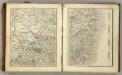
Sheets 35-36. (Cary's England, Wales, and Scotland).
1 : 360000 Cary, John, ca. 1754-1835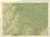
Cambridge, Huntingdon, Sheet 19 - Bartholomew's "Half Inch to the Mile Maps" of England & Wales
1 : 126720 Topographic maps Bartholomew, John George John Bartholomew & Co
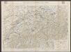
Comitatus Northantonensis vernacule Northamton Shire
1 : 220000 [Amstelodami] : [apud Joannem Janssonium]
Comitatus Northantonensis vernacule Northampton Shire. [Karte], in: Novus atlas absolutissimus, Bd. 7, S. 309.
1 Karte aus Atlas Janssonius Offizin
Comitatus Northantonensis; Vernacule Northamton Shire. [Karte], in: Theatrum orbis terrarum, sive, Atlas novus, Bd. 4, S. 320.
1 Karte aus Atlas Blaeu, Joan Blaeu, Willem Janszoon
SUFFOLCIAE Comitatus f.38
This is a map of Suffolk by Christopher Saxton which dates from 1576. It forms part of an atlas that belonged to William Cecil Lord Burghley, Elizabeth I’s Secretary of State, who used this atlas to illustrate domestic matters. This map is actually a proof copy of one which forms part of Christopher Saxton’s Atlas of England and Wales. This atlas was first published as a whole in 1579. It consists of 35 coloured maps depicting the counties of England and Wales. The atlas is of great significance to British cartography as it set a standard of cartographic representation in Britain and the maps remained the basis for English county mapping, with few exceptions, until after 1750. During the reign of Elizabeth I, map use became more common, with many government matters referring to increasingly accurate maps with consistent scales and symbols, made possible by advances in surveying techniques. Illustrating the increasing use of maps in government matters, Lord Burghley, who had been determined to have England and Wales mapped in detail from the 1550s, selected the cartographer Christopher Saxton to produce a detailed and consistent survey of the country. The financier of the project was Thomas Seckford Master of Requests at the Court of Elizabeth I, whose arms appear, along with the royal crest, on each map. This map, unlike many of the others in the series, is divided into administrative units called hundreds which are shown by areas of different coloured. Lord Burghley has added information to the map, particularly along the coast line, knowledge of which was vital for defence.The map was engraved by Lenaert Terwoot, one of a team of seven English and Flemish engravers employed to produce the copper plates for the atlas. Saxton, Christopher Terwoot, Lenaert
COMITATVS | NORTHANTO- | NENSIS; | Vernacule | NORTHAMTON SHIRE.
[Amsterdam : Joan Blaeu]
Map of Northhamptonshire, Bedfordshire, Cambridgeshire, Huntigdonshire and Rutland
This is a manuscript map of Northamptonshire, Bedfordshire, Cambridgeshire, Huntingdonshire and Rutland, a page from an atlas that belonged to William Cecil Lord Burghley, Elizabeth I’s Secretary of State. Burghley used this atlas to illustrate domestic matters.It is in a hand pre dating 1570 and may be the work of John Rudd. Rudd was the man to whom Christopher Saxton was an apprentice to in 1570. John Rudd was Vicar of Dewsbury from 1554 to 1570. Rudd had a keen interest in cartography and had been engaged in the 1550’s in making a platt’ of England. In 1561 Rudd was granted leave to travel further to map the country and it is likely that Saxton accompanied him, acquiring his skills for surveying. Rudd, John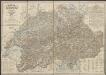
Comitatus Northantonensis; Vernacule Northampton Shire. [Karte], in: Le théâtre du monde, ou, Nouvel atlas contenant les chartes et descriptions de tous les païs de la terre, Bd. 4, S. 280.
1 Karte aus Atlas Blaeu, Willem Janszoon und Blaeu, Joan Blaeu, Willem Janszoon
Comitatus Northantonensis; Vernacule Northamton Shire. [Karte], in: Theatrum orbis terrarum, sive, Atlas novus, Bd. 4, S. 320.
1 Karte aus Atlas Blaeu, Joan Blaeu, Willem Janszoon
Suffolcia vernacula Suffolke. [Karte], in: Novus atlas absolutissimus, Bd. 7, S. 276.
1 Karte aus Atlas Janssonius Offizin
SVFFOLCIA. | Vernacule | SVFFOLKE.
[Amsterdam : Joan Blaeu]
SUFFOLCIAE Comitatus Sheet 16
This map of Suffolk is from the 1583 edition of the Saxton atlas of England and Wales.This atlas was first published as a whole in 1579. It consists of 35 coloured maps depicting the counties of England and Wales. The atlas is of great significance to British cartography as it set a standard of cartographic representation in Britain and the maps remained the basis for English county mapping, with few exceptions, until after 1750. During the reign of Elizabeth I map use became more common, with many government matters referring to increasingly accurate maps with consistent scales and symbols, made possible by advances in surveying techniques. Illustrating the increasing used of maps in government matters, Lord Burghley, Elizabeth I’s Secretary of State, who had been determined to have England and Wales mapped in detail from the 1550s, selected the cartographer Christopher Saxton to produce a detailed and consistent survey of the country. The financier of the project was Thomas Seckford Master of Requests at the Court of Elizabeth I, whose arms appear, along with the royal crest, on each map. Saxton, Christopher Ryther, Augustine
Suffolcia vernacule Suffolke
1 : 240000 Joannes Janssonius excudit. [Amstelodami] : [apud Joannem Janssonium]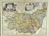
An accurate map of the county of Suffolk
1 Karte : Kupferdruck ; 50 x 69 cm Bowen; Hinton sold by I. Hinton at the Kings Arms in St. Pauls Church Yard
Suffolcia. Vernacule Suffolke. [Karte], in: Theatrum orbis terrarum, sive, Atlas novus, Bd. 4, S. 285.
1 Karte aus Atlas Blaeu, Joan Blaeu, Willem Janszoon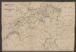
Suffolcia. Vernacule Suffolke. [Karte], in: Le théâtre du monde, ou, Nouvel atlas contenant les chartes et descriptions de tous les païs de la terre, Bd. 4, S. 253.
1 Karte aus Atlas Blaeu, Willem Janszoon und Blaeu, Joan Blaeu, Willem Janszoon
Suffolcia. Vernacule Suffolke. [Karte], in: Theatrum orbis terrarum, sive, Atlas novus, Bd. 4, S. 285.
1 Karte aus Atlas Blaeu, Joan Blaeu, Willem Janszoon
Suffolcia vernacula Suffolke
1 Karte : Kupferdruck ; 36 x 47 cm Valck; Schenk penes Gerardum Valk et Petrum Schenk
Svffolcia, vernacule Svffolke
1 Karte : Kupferdruck ; 37 x 48 cm Blaeu Joan Blaeu
Comitatis Cantabrigiensis, vernacule Cambridge Shire
1 : 210000 Amstelodami : apud Joannem Janssonium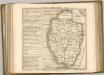

Comitatis Cantabrigiensis; vernacule Cambridgeshire. [Karte], in: Novus atlas absolutissimus, Bd. 7, S. 294.
1 Karte aus Atlas Janssonius Offizin
Cantabrigiensis Comitatus; Cambridge Shire. [Karte], in: Theatrum orbis terrarum, sive, Atlas novus, Bd. 4, S. 306.
1 Karte aus Atlas Blaeu, Joan Blaeu, Willem Janszoon
An accurate map of Northampton Shire
1 Karte : Kupferdruck ; 68 x 51 cm Bowen; Hinton sold by I. Hinton at the Kings Arms in Newgate street
Comitatvs Northantonensis vernacule Northamton Shire
1 Karte : Kupferdruck ; 37 x 49 cm Valck; Schenk prostant in officina penes Gerardi Valk et Petri Schenk
Comitatvs Northantonensis; vernacule Northamton Shire
1 Karte : Kupferdruck ; 40 x 48 cm Blaeu Joan Blaeu