Maps of Malay Archipelago
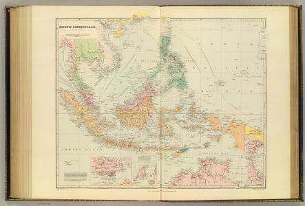
Asiatic Archipelago.
1 : 94000000 Stanford, Edward
Asiatic Archipelago.
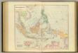
1 : 9500000 Arrowsmith, John
Asiatic Archipelago.
1 : 9500000 Arrowsmith, John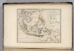
Islands of the East Indies.
1 : 23000000 Carey, Mathew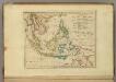
Islands of the East Indies.
1 : 23000000 Carey, Mathew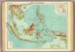
Malay Archipelago.
1 : 10000000 John Bartholomew and Son
Malay Archipelago, Or East India Islands.
1 : 21500000 Tallis, J. & F.
Islands: China-New Holland.
1 : 23000000 Bowen, Frances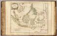
Indes Orientales.
1 : 8400000 Robert de Vaugondy, Gilles, 1688-1766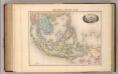
Indo-Chine et Archipel D'Asie.
1 : 14400000 Migeon, J.
Die Ostindischen Inseln
Hand-Atlas über alle Theile der Erde nach dem neuesten Zustande und über das Weltgebäude Stieler, Adolf bei Justus Perthes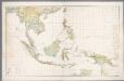
Nederlandsch-Indië en omgeving / Topografische Dienst
1 : 5000000 Topographische Dienst in Nederlandsch-Indië Batavia : Topografische Dienst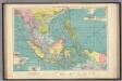
East Indian ports.
1 : 10000000 Philip, George
Indiae Orientalis Nova Descriptio [Karte], in: Gerardi Mercatoris et I. Hondii Newer Atlas, oder, Grosses Weltbuch, Bd. 2, S. 362.
1 Karte aus Atlas Mercator, Gerhard und Hondius, Jodocus Jansson, Jan
Insulae Indiae Orientalis Praecipuae, In quibus Moluccae celeberrimae sunt. [Karte], in: Gerardi Mercatoris Atlas, sive, Cosmographicae meditationes de fabrica mundi et fabricati figura, S. 538.
1 Karte aus Atlas Mercator, Gerhard Montanus, Petrus
Indiae Orientalis Nova Descriptio [Karte], in: Novus atlas absolutissimus, Bd. 6, S. 150.
1 Karte aus Atlas Janssonius Offizin
Iles de la Sonde, Philippines.
1 : 11700000 Garnier, F. A., 1803-1863
Hinterindien, Malayische Archipel.
1 : 18000000 Andree, Richard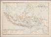
1. Overzichtskaart van den Nederlandsch Oost Indischen Archipel, uit: Atlas van Nederlandsch Oost-Indië / samengest. door Topographisch Bureau te Batavia van 1897-1904
Annotatie: Omgewerkte versie van: Atlas der Nederlandsche bezittingen in Oost-Indië / naar de nieuste bronnen samengest. door J.W. Stemfoort en J.J. ten Siethoff. - 's-Gravenhage : Topographische Inrichting, [ca. 1885] Topographisch Bureau, Batavia 's-Gravenhage : Topographische Inrichting
Die Ostindischen Inseln
Handatlas über alle Theile der Erde und über das Weltgebäude Stieler, Adolf Justus Perthes
Ostindien & China
Atlas der Hydrographie Berghaus, Hermann Justus Perthes
Japanese aerodromes in Southwest Pacific Area, 20th November, 1944 / comp. by Allied Air Force SWPA
Allied Air Force SWPA [S.l.] : Allied Air Force SWPA
Neueste Karte der Ostindischen Inseln
Grosser Hand-Atlas über alle Theile der Erde in 170 Karten Meyer, J. Verlag des Bibliographischen Instituts
Dutch Possessions, in the Indian Archipelago.
1 : 13305600 Fullarton, A. & Co.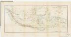
[Kaart], uit: Overzichtskaart van den Nederlandsch-Indischen Archipel / uitgave van de Afdeeling Handel van het Departement van Landbouw, Nijverheid en Handel
1 : 10000000 titelvariant: Nederlandsch-Indië; Annotatie: Omslagtitel: Nederlandsch-Indië; Annotatie geografische gegevens: Legenda Departement van Landbouw, Nijverheid en Handel, Buitenzorg. Afdeeling Handel Buitenzorg : Departement van Landbouw, Nijverheid en Handel / (Weltevreden (Batavia) : Reproductiebedrijf Topografische Dienst)
Atlas für Handel und Industrie: Für Kaufleute, Fabrikante u. Gewerbetreibende, Handlungs- u. Gewerbe-Schulen

Kaert van de Molocques : zeer correckt afgheteyckent met allen zijn eylanden ende sterckten, met een afbeeldinghe van de Straat van Botton / [Jan Cornelisz. Moy?]
[S.l. : s.n.]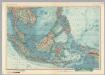
South-East Asia. Pergamon World Atlas.
1 : 10000000 Polish Army Topography Service
[Die Niederlaendischen u. Spanischen Südsee Inseln]
[Allgemeiner Atlas über alle Theile der Erde in 29 Blättern] Ziegler, Jakob Melchior Top. Anstalt v. J. Wurster u. Comp.