Maps of Malay Archipelago

Maps of Malay Archipelago

$title$

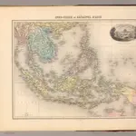
Indo-Chine et Archipel D'Asie.

1 : 14400000 Migeon, J.
$title$

Islands of the East Indies.

1 : 23000000 Carey, Mathew
$title$

Islands of the East Indies.

1 : 23000000 Carey, Mathew
$title$

East Indian ports.

1 : 10000000 Philip, George
$title$

Indiae Orientalis Nova Descriptio [Karte], in: Gerardi Mercatoris et I. Hondii Newer Atlas, oder, Grosses Weltbuch, Bd. 2, S. 362.

1 Karte aus Atlas Mercator, Gerhard und Hondius, Jodocus Jansson, Jan
$title$

Islands: China-New Holland.

1 : 23000000 Bowen, Frances
$title$

Asiatic Archipelago.

1 : 9500000 Arrowsmith, John
$title$

Indiae Orientalis Nova Descriptio [Karte], in: Novus atlas absolutissimus, Bd. 6, S. 150.

1 Karte aus Atlas Janssonius Offizin
$title$

Nederlandsch-Indië en omgeving / Topografische Dienst

1 : 5000000 Topographische Dienst in Nederlandsch-Indië Batavia : Topografische Dienst
$title$

Malay Archipelago.

1 : 10000000 John Bartholomew and Son
$title$

Malay Archipelago, Or East India Islands.

1 : 21500000 Tallis, J. & F.
$title$

Asiatic Archipelago.

1 : 94000000 Stanford, Edward
$title$

Insulae Indiae Orientalis Praecipuae, In quibus Moluccae celeberrimae sunt. [Karte], in: Gerardi Mercatoris Atlas, sive, Cosmographicae meditationes de fabrica mundi et fabricati figura, S. 538.

1 Karte aus Atlas Mercator, Gerhard Montanus, Petrus
$title$

Asiatic Archipelago.

1 : 9500000 Arrowsmith, John
$title$

Hinterindien, Malayische Archipel.

1 : 18000000 Andree, Richard
$title$

Iles de la Sonde, Philippines.

1 : 11700000 Garnier, F. A., 1803-1863
$title$

Ostindien & China

Atlas der Hydrographie Berghaus, Hermann Justus Perthes
$title$

Indes Orientales.

1 : 8400000 Robert de Vaugondy, Gilles, 1688-1766
$title$

Japanese aerodromes in Southwest Pacific Area, 20th November, 1944 / comp. by Allied Air Force SWPA

Allied Air Force SWPA [S.l.] : Allied Air Force SWPA
$title$

East India Islands.

1 : 21500000 Arrowsmith, Aaron
$title$

East India Islands.

1 : 21500000 Arrowsmith, Aaron
$title$

Kaart van den Oost-Indischen Archipel

[Java und Madoera, geologische Detailkarten und Profile] Verbeek, R. D. M. Joh. C. Stemler Cz.
$title$

95-96. Indocina, Siam, Arcipelago Malese.

1 : 10000000 Touring club italiano
$title$

Ostindische Inseln

1 : 12500000 Filipíny Berghaus, Herm. Eberhardt, H. Justus Perthes
$title$

Die Ostindischen Inseln

Hand-Atlas über alle Theile der Erde nach dem neuesten Zustande und über das Weltgebäude Stieler, Adolf bei Justus Perthes
$title$

Kaert van de Molocques : zeer correckt afgheteyckent met allen zijn eylanden ende sterckten, met een afbeeldinghe van de Straat van Botton / [Jan Cornelisz. Moy?]

[S.l. : s.n.]
$title$

Atlas für Handel und Industrie: Für Kaufleute, Fabrikante u. Gewerbetreibende, Handlungs- u. Gewerbe-Schulen

$title$

Ostindische Inseln

Adolf Stieler's Handatlas über alle Theile der Erde und über das Weltgebäude Stieler, Adolf Justus Perthes
$title$

Ost-Asien / Neubearb. von Richard Kiepert und Paul Sprigade

1 : 12000000 Richard Kiepert 1846-1915; Paul Sprigade Berlin : Dietrich Reimer (Ernst Vohsen)
$title$

Die Ostindischen Inseln

Handatlas über alle Theile der Erde und über das Weltgebäude Stieler, Adolf Justus Perthes
© MapTiler © OpenStreetMap contributors
How does it work?
These instructions will show you how to find historical maps online.
Getting started
Type the place name in the search box to find the exact location. You can further adjust the search by zooming in and out.
Zoom
Zoom in and out with the buttons or use your mouse or touchpad natively.
Exact Area tool
Click here and draw a rectangle over the map to precisely define the search area.
Set filters
Narrow your search with advanced settings, such as Years (from/to), Fulltext, Publisher, etc.
Results
See the results of your search on the right side. You can scroll down to find more maps of this location.
?

Download OldMapsOnline Mobile