Maps of Malay Archipelago

Neueste Karte der Ostindischen Inseln
Grosser Hand-Atlas über alle Theile der Erde in 170 Karten Meyer, J. Verlag des Bibliographischen Instituts
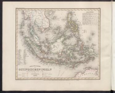
Die Ostindischen Inseln
Handatlas über alle Theile der Erde und über das Weltgebäude Stieler, Adolf Justus Perthes
Die Ostindischen Inseln
Hand-Atlas über alle Theile der Erde nach dem neuesten Zustande und über das Weltgebäude Stieler, Adolf bei Justus Perthes
Ostindischen Inseln.
1 : 14700000 Radefeld, Carl Christian Franz, 1788-1874
East India Isles.
1 : 7200000 Pinkerton, John, 1758-1826
Malaisie.
1 : 18500000 Malte-Brun, Conrad, 1775-1826
Kaert van de Molocques : zeer correckt afgheteyckent met allen zijn eylanden ende sterckten, met een afbeeldinghe van de Straat van Botton / [Jan Cornelisz. Moy?]
[S.l. : s.n.]
Grand Archipel d'Asie.
1 : 10200000 Picquet, C.
Atlas für Handel und Industrie: Für Kaufleute, Fabrikante u. Gewerbetreibende, Handlungs- u. Gewerbe-Schulen
Grand Archipel d'Asie.
1 : 10200000 Brue, Adrien Hubert, 1786-1832
East India Islands.
1 : 10000000 Hall, S. (Sidney)
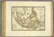
Die Ostindischen Inseln
Hand-Atlas über alle Theile der Erde nach dem neuesten Zustande und über das Weltgebäude Stieler, Adolf bei Justus Perthes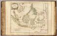
Indes Orientales.
1 : 8400000 Robert de Vaugondy, Gilles, 1688-1766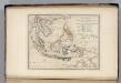
Islands of the East Indies.
1 : 23000000 Carey, Mathew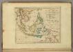
Islands of the East Indies.
1 : 23000000 Carey, Mathew
Iles de la Sonde, Philippines.
1 : 11700000 Garnier, F. A., 1803-1863
Die Ostindischen Inseln
Stieler's Hand-Atlas Stieler, Adolf bei Justus Perthes
East Indies.
1 : 12672000 Colton, G.W.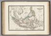
Malaisie.
1 : 1200000 Levasseur, E.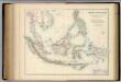
Indian Archipelago.
1 : 9187200 Fullarton, A. & Co.
East India Islands.
1 : 21500000 Arrowsmith, Aaron
East India Islands.
1 : 21500000 Arrowsmith, Aaron
Algemeene kaart van Nederlands Oostindie : op de schaal van 1:5.000.000 ontworpen naar de beste kaarten en bronnen / geteekend door W. Beyerinck, J.M. Bruyn en J.F.W.A. Essers, Kadetten bestemd voor de dienst in de Oostindiën ; gelithographeerd by de Koninklijke Militaire Akademie door F.J. Ensink
[Den Haag : Ministerie van Koloniën]
Hinterindien und Malaien-Archipel
1 : 18000000 Malajsie Meyer, Joseph Bibliographisches Institut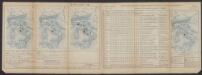
Insulae Indiae Orientalis Praecipuae, In quibus Moluccae celeberrimae sunt. [Karte], in: Gerardi Mercatoris Atlas, sive, Cosmographicae meditationes de fabrica mundi et fabricati figura, S. 538.
1 Karte aus Atlas Mercator, Gerhard Montanus, Petrus
Kaart van den Oost-Indischen Archipel
[Java und Madoera, geologische Detailkarten und Profile] Verbeek, R. D. M. Joh. C. Stemler Cz.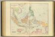
Asiatic Archipelago.
1 : 94000000 Stanford, Edward
Ostindien & China
Atlas der Hydrographie Berghaus, Hermann Justus Perthes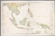
Nederlandsch-Indië en omgeving / Topografische Dienst
1 : 5000000 Topographische Dienst in Nederlandsch-Indië Batavia : Topografische Dienst