Maps of Switzerland

Switzerland.
1 : 1450000 Bowen, Frances
Suisse or Switzerland.
1 : 1500000 Moll, Herman, d. 1732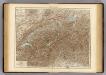
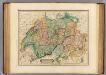
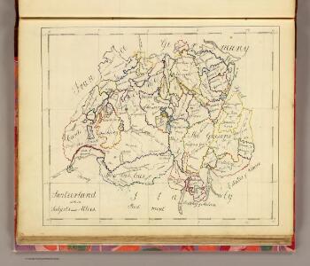
Switzerland.
1 : 800000 Andree, Richard; Times (London, England)
Schweiz mit den projectirten Eisenbahnen
1 : 1200000 Joh. Wurster u. Comp.
Carte de la Suisse pour les écoles
1 : 700000 Leuzinger, Rudolf J. Dalp'sche Buch & Kunsthandlung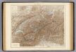
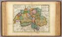
Die Schweiz.
1 : 800000 Andree, Richard
Carte de la Suisse pour les écoles
1 : 700000 Leuzinger, Rudolf J. Dalp'sche Buch und Kunsthandlung
Helvetia cum finitimis regionibus confoederatis
1 : 800000 1 Karte per Gerardum Mercatorem [Mercator], [Duisburg]
Charte von der Republik Schweiz
Neuester Schul-Atlas Walch, Johann im Verlag bei Joh. Walch
Erste Reisekarte [der Schweiz]
1 : 500000 1 Karte Heinrich Keller [Keller], [Zürich]
Carte de Suisse
1 Karte dressée sur les mémoires de Merveilleux par Guillaume De l'Isle ; augmenté en 1759 par Phil. Buache chez l'auteur sur le Quay de l'Horloge, Paris
Switzerland.
1 : 950400 Colton, G.W.
Helvetia, cum finitimis regionibus confoederatis. [Karte], in: Le théâtre du monde, ou, Nouvel atlas contenant les chartes et descriptions de tous les païs de la terre, Bd. 1, S. 276.
1 Karte aus Atlas Blaeu, Willem Janszoon und Blaeu, Joan Blaeu, Willem Janszoon
Karte der Schweiz
1 : 400000 1 Karte par R. Leuzinger Schmid & Francke, Berne
H. Keller's erste Reisecharte der Schweiz
1 : 500000 1 Karte gravé par J. Scheurmann Keller, Zürich
Exactissima Helvetiae Rhaetiae, Valesiae caeterorumq. confoederatorum ut et finitimorum populorum regionum tabula / ex conatibus Nicolaum Visscher Amst. Bat. ; A. Hogeboom sculp
1 : 800000 Annotatie: Cum privil. praepotentiss. Ordinum General. Belgii Foederati; Met opdracht van Nicolaus Visscher; Origineel is Blad 117 in atlas factice; Annotatie geografische gegevens: Met 5 schaalstokken; Legenda Nicolaes Jansz. Visscher jr. 1649-1702; Andries Hogeboom fl. 1665-1682 Amst. Bat. : ex conatibus Nicolai Visscher
Keller's Reisekarte der Schweiz
1 : 500000 1 Karte [gezeichnet v. Heinrich Keller] ; [gest. v. Johann Jakob Scheuermann] Heinrich Fuessli und Comp. Comm., Zürich
Nova Helvetiae tabula geographica illustrissimis et potentissimis cantonibus et rebuspublicis reformatae religionis Tigurinae, Bernensi, Glaronensi, Basiliensi, Scaphusianae, Abbatis Cellanae
1 : 320000 1 Karte auf 4 Bl. dominis suis clementissimis humilime dicata a Ioh. Iacobo Scheuchzero Tigurino ex officina Petri Schenckii, Amstelaedami
Keller's erste Reisekarte der Schweiz
1 : 500000 1 Karte Keller, Zürich
Exactissima Helvetiae, Rhaetiae, Valesiae caeterorumq. confoederatorum ut et finitimorum populorum regionum tabula
1 Karte ex conatibus Nicolai Visscher ; A. Hogeboom sculp. Visscher, [Amsterdam]
Keller's Reisekarte der Schweiz
1 : 500000 1 Karte Heinrich Fuessli und Comp. Comm., Zürich
Swisserland, Mt. Blanc.
1 : 750000 Thomson, John
Original von Keller's erster Reisekarte der Schweiz
1 : 500000 1 Karte Heinrich Keller, Zürich
Carte generale des treize cantons suisses, et des differents etats de leur dependance
1 Karte : Kupferdruck ; 41 x 48 cm Châtelain s.n.
Karte der Schweiz
1 : 400000 1 Karte bearbeitet nach Dufour = Carte de la Suisse / d'après la carte Dufour par R. Leuzinger Verlag der J. Dalp'schen Buchhandlung, Berne
[Kellers Reisekarte der Schweiz]
1 : 500000 1 Karte [Heinrich Keller] [Keller], [Zürich]
<<La>> Suisse divisée en ses cantons, ses alliés et sujets et distinguée en pays catholiques, protestans et mixtes
1 : 1250000 1 Karte par [Louis] Brion chez Desnos, Rue St-Jacques au Globe, Paris
Charte von Helvetien und Wallis
1 : 600000 Götze, Ferdinand im Verlage des Landes Industrie Comptoirs