Maps of Switzerland
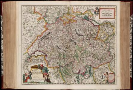
Exactissima Helvetiae Rhaetiae, Valesiae caeterorumq. confoederatorum ut et finitimorum populorum regionum tabula / ex conatibus Nicolaum Visscher Amst. Bat. ; A. Hogeboom sculp
1 : 800000 Annotatie: Cum privil. praepotentiss. Ordinum General. Belgii Foederati; Met opdracht van Nicolaus Visscher; Origineel is Blad 117 in atlas factice; Annotatie geografische gegevens: Met 5 schaalstokken; Legenda Nicolaes Jansz. Visscher jr. 1649-1702; Andries Hogeboom fl. 1665-1682 Amst. Bat. : ex conatibus Nicolai Visscher
Exactissima Helvetiae, Rhaetiae, Valesiae caeterorumq. confoederatorum ut et finitimorum populorum regionum tabula
1 Karte ex conatibus Nicolai Visscher ; A. Hogeboom sculp. Visscher, [Amsterdam]
Übersichtskarte der Schweizer-Alpen
1 : 700000 Verlag der J. Dalp'schen Buch & Kunsthandlung (Carl Schmid)
Geographisches Verzeichniss der merkwürdigsten Orte in der Schweiz
1 : 700000 Körner, Heinrich ; Holzhalb, Hans Rudolf [s.n.]
Karte der Schweiz
1 : 400000 1 Karte par R. Leuzinger Schmid & Francke, Berne
Übersichtskarte des schweizerischen Pegel und Witterungsstationennetzes
1 : 600000 Topogr. Anstalt v. Wurster, Randegger & Cie
Nouvelle carte illustrée de la Suisse présentant les divisions physiques et politiques, les routes et les chemins de fer, les villes industrielles, les lieux remarquables par des curiosités naturelles
Vuillemin, Alexandre Delarue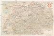
Tourist map of Switzerland
1 : 600000 Evropa Swiss national tourist office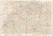
Automobil-Karte der Schweiz
1 : 400000 Švýcarsko Kümmerly & Frey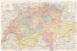
Reise- und Verkehrskarte der Schweiz
1 : 400000 Švýcarsko A. Meissner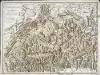
Carte générale de la Suisse et de ses environs
1 Karte : Kupferdruck ; 40 x 56 cm Monti; Buache chez F. Monti
Switzerland.
1 : 1270000 Mitchell, Samuel Augustus
Switzerland.
1 : 1270000 Mitchell, Samuel Augustus
Die Schweiz
Grosser Hand-Atlas über alle Theile der Erde in 170 Karten Meyer, J. Verlag des Bibliographischen Instituts
Nova et accuratissima Helvetiae foederatarumque cum ea, nec non subditarum, regionum tabula
1 Karte primum composita per de l'Isle, nunc vero aucta & emendata = Les cantons suisses, leurs alliés & pays sujets / composée par Guillaume de l'Isle, corrigée & augmentée le plus nouvelles chez I.B. Elwe, Amsterdam
Die Schweiz.
1 : 1400000 Reichard, C. G.
Nova et accuratissima Helvetiae foederatarumque cum ea, nec non subditarum, regionum tabula
1 Karte primum composita per de l'Isle, nunc vero aucta & emendata = Les cantons suisses, leurs alliés & pays sujets / composée par Guillaume de l'Isle, corrigée & augmentée, le plus nouvelles chez Elwe & Langeveld, Amsterdam
Helvetia
1 : 1700000 1 Karte [von Heinrich Heidegger] [bey Orell, Füssli und Compagnie], [Zürich]
Karte der Schweiz
1 : 400000 1 Karte von R. Leuzinger ; Schrift von Ch. v. Hoven = Carte de la Suisse / par R. Leuzinger chez J. Dalp (C.Schmid), Berne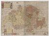
Karte der Schweiz von 1657
1 : 500000 Originaltitel: Helvetiae, Rhaetiae et Valesiae caeterorumque Confoederatorum ut et finitimorum Populorum. Tabula Geographica et Hydrographica nova et exacta. Neudruck (mittels revidierter und teilweise nachgestochener Kupferplatten) der von Hans Conrad Gyger, andere Schreibweisen: Geiger, Geyger, (1599-1674), Kartograf, Ingenieur und Amtmann des Amts Kappelerhof, von Zürich, gezeichneten und von Conrad Meyer (1618-1689), Maler, Zeichner und Radierer, von Zürich, gestochenen Originalkarte. Mit (am linken und rechten Bildrand) farbigen Wappen der Dreizehnörtigen Eidgenossenschaft sowie der elf Zugewandten Orte und mit (am linken unteren Bildrand) den Wappen der neuen Gemeinen Herrschaften Baden, Frauenfeld, Freiämter, Sargans, Rheintal, Lugano, Locarno, Mendrisio und Meinthal. Mit einer Erklärung der Zeichen. Karte aus zwei zusammensetzbaren Blättern (zwei Kupferdruckplatten). Gyger, Hans Georg (1627-1687), Maler und Amtmann des Klosteramts Küsnacht, von Zürich
Kleine offizielle Eisenbahnkarte der Schweiz
1 : 500000 Mit Legenden in deutscher und französischer Sprache. Eidgenössisches Post- und Eisenbahndepartement, Bern Geograph. artist. Anstalt Kümmerly und Frey, Bern
Eisenbahnkarte der Schweiz
Mit Legende. Ohne Datumsangabe. Kommissionsverlag: Wurster, Randegger und Cie., in Winterthur Herausgeber: Frei, H., in Zürich; Tissot, H., in Zürich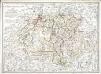
Carte générale de la Suisse et de ses environs
1 Karte : Kupferdruck ; 41 x 56 cm Monti chez F. M. F. Monti
Physikalische Karte der Schweiz
1 : 800000 1 Karte R. Leuzinger J. Dalp (C. Schmid), Bern
Nova totius Helvetiae cum suis subditis ac sociis tab. geogr
1 : 790000 1 Karte studio manu ac sumtibus Matth. Seut. Seutter, [Augsburg]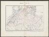
Historischer Atlas der Schweiz
1501 - 1536 Mandrot, Louis-Alphonse de Deutsche Buchhandlung von J. Kessmann
Kleine officielle Eisenbahnkarte der Schweiz
1 : 500000 1 Karte gest. von R. Leuzinger ; Schweizer. Post- und Eisenbahndepartement = Petite carte officielle des chemins de fer de la Suisse Kümmerly, Bern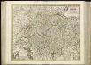
[53][53] Exactissima Helvetiae, Rhetioae, Valesia ..., uit: Atlas sive Descriptio terrarum orbis
Annotatie: Gedigitaliseerde versie. Amsterdam. Heiloo : Picturae (vervaardiger), 2015. tiff-bestand. Gedigitaliseerd: 07-01-2015; Origineel: Universiteitsbibliotheek Vrije Universiteit (XL.05127.-) ; Netherlands; Titelpagina ontbreekt Wit, Frederik de Amsterdam : Frederick de Wit
Nova totius Helvetiae tabula exhibens ejus XIII pagos, cantones dictos, unâ cùm sociorum ditionibus atque communium subditorum provinciis
1 Karte adornata et aeri incisa a Benedicto Roth Bernensi 1730 [Verlag nicht ermittelbar], [Erscheinungsort nicht ermittelbar]