Maps of Switzerland

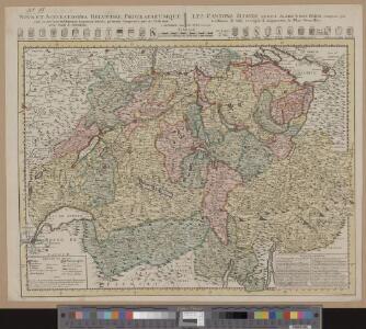
Nova et accuratissima Helvetiae foederatarumque cum ea, nec non subditarum, regionum tabula
1 Karte primum composita per de l'Isle, nunc vero aucta & emendata = Les cantons suisses, leurs alliés & pays sujets / composée par Guillaume de l'Isle, corrigée & augmentée le plus nouvelles chez I.B. Elwe, Amsterdam
Nova et accuratissima Helvetiae foederatarumque cum ea, nec non subditarum, regionum tabula
1 Karte primum composita per de l'Isle, nunc vero aucta & emendata = Les cantons suisses, leurs alliés & pays sujets / composée par Guillaume de l'Isle, corrigée & augmentée, le plus nouvelles chez Elwe & Langeveld, Amsterdam
Tourist map of Switzerland
1 : 600000 Evropa Swiss national tourist office
Automobil-Karte der Schweiz
1 : 400000 Švýcarsko Kümmerly & Frey
Reise- und Verkehrskarte der Schweiz
1 : 400000 Švýcarsko A. Meissner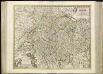
[53][53] Exactissima Helvetiae, Rhetioae, Valesia ..., uit: Atlas sive Descriptio terrarum orbis
Annotatie: Gedigitaliseerde versie. Amsterdam. Heiloo : Picturae (vervaardiger), 2015. tiff-bestand. Gedigitaliseerd: 07-01-2015; Origineel: Universiteitsbibliotheek Vrije Universiteit (XL.05127.-) ; Netherlands; Titelpagina ontbreekt Wit, Frederik de Amsterdam : Frederick de Wit
Reliefkarte der Schweiz
Originaltitel: Nova Helvetiae Tabula geographica Illustrissimis et Potentissimis Cantonibus et Rebuspublicis Reformatae Religionis Tigurinae, Bernensi, Glaronensi, Basilensi, Scaphusianae, Abbatis cellanae. Scheuchzer, Johann Jakob (1672-1733), Arzt und Naturforscher, von Zürich
<<L'>>Elvezia divisa ne suoi tredici cantoni e suoi alleati
1 : 900000 1 Karte G. Zuliani inc. ; G. Pitteri scri. presso Antonio Zatta, Venezia
Nova Helvetiae tabula geographica illustrissimis et potentissimis cantonibus et rebuspublicis reformatae religionis Tigurinae, Bernensi, Glaronensi, Basiliensi, Scaphusianae, Abbatis Cellanae
1 : 230000 1 Karte auf 4 Bl. dominis suis clementissimis humilime dicata a Ioh. Iacobo Scheuchzero Tigurino ; Ioh. Melch. Füsslin ornamenta pinx. ; Ioh. Henr. Huber et Eman. Schalch sculps. [Hofmeister], [Zürich]
Carte de la Suisse où sont les treize cantons, leurs alliés, et leurs sujets
1 Karte dressée sur les meilleurs auteurs après des observations faites sur les lieux et publiée par François Grasset ; E. Dussy scripsit ; [C. Aldring sculp.] Grasset, Lausanne
Switzerland.
1 : 1270000 Tanner, Henry S.
Nova totius Helvetiae cum suis subditis ac sociis tab. geogr
1 : 790000 1 Karte studio manu ac sumtibus Matth. Seut. Seutter, [Augsburg]
Swisserland.
1 : 750000 Cary, John, ca. 1754-1835
Kleine officielle Eisenbahnkarte der Schweiz
1 : 500000 1 Karte gest. von R. Leuzinger ; Schweizer. Post- und Eisenbahndepartement = Petite carte officielle des chemins de fer de la Suisse Kümmerly, Bern
Nouvelle carte de la Suisse dans laquelle sont exactement distingués les treize cantons, leurs alliés et leurs sujets
1 Karte dréssée sur les mémoires les plus corrects et assujettis aux observations astronomiques [par William Faden] chez W. Faden, Charing Cross, Londre
Landeskarte der Schweiz 1 : 25000: Den Kanton Zürich betreffende Blätter: Übersicht der Blätter
Eidgenössische Landestopographie, in Köniz-Wabern
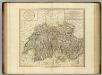
Nova Helvetiae, foederatarumque cum ea, nec non subditarum regionum tabula, ad usum serenissimi Burgundiae ducis, secundum commentarios domini Merveilleux
1 Karte composita per Gulielmum de l'Isle apud Joh. Covens & Corn. Mortier, Amstelodami
Kleine officielle Eisenbahnkarte der Schweiz
1 : 500000 1 Karte gest. von R. Leuzinger ; Schweizerisches Post- & Eisenbahndepartement Kümmerly, Bern
Officielle Eisenbahnkarte der Schweiz
1 : 500000 1 Karte Kümmerly & Frey, Bern
Kleine offizielle Eisenbahnkarte der Schweiz
1 : 500000 Mit Legenden in deutscher und französischer Sprache. Eidgenössisches Post- und Eisenbahndepartement, Bern Geograph. artist. Anstalt Kümmerly und Frey, Bern
Die Schweiz mit den projektierten Eisenbahnen; Übersichtskarte
Mit Legende. Ohne Datumsangabe. Joh. Wurster und Comp., in Winterthur
Carte de Suisse ou sont les treize cantons, leurs alliés et leurs sujets
1 Karte dressée, rectifiée et augmentée sur les meilleurs auteurs, sur plusieurs cartes manuscrites et observations faites sur les lieux par Abr. Rouvier ; T. Kitchin sculp. Carington Bowles, at No 69 in St. Pauls Church yd., [London]
<<La>> Suisse divisée en ses treze canton, ses alliéz et ses sujets
1 : 1250000 1 Karte [Homännische Erben?], [Nürnberg?]
Officielle Eisenbahnkarte der Schweiz
1 : 500000 1 Karte Schweiz. Post- & Eisenbahndepartement = Carte officielle des chemins de fer de la Suisse Kümmerly, Bern
Carte de la Suisse où sont les treize cantons, leurs alliés, et leurs sujets
1 Karte dressée sur les meilleurs auteurs et d'après des observations faites sur les lieux et publiés par François Grasset ; Aldring sculp. ; E. Dussy scripsit Grasset, Lausanne
Geographisches Verzeichniss der merkwürdigsten Orte in der Schweiz
1 : 700000 Körner, Heinrich ; Holzhalb, Hans Rudolf [s.n.]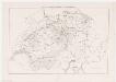
Landesgebiet beider kriegführender Teile im Sonderbundkrieg; Übersichtskarte
Ohne Datumsangabe. Joh. Wurster und Comp., in Winterthur
Carte de la Suisse où sont les treize cantons, leurs alliés, et leurs sujets
1 Karte dressée sur les meilleurs auteurs et d'après des observations faites sur les lieux et publiés par François Grasset ; Aldring sculp. ; E. Dussy scripsit Grasset, Lausanne