Maps of Switzerland

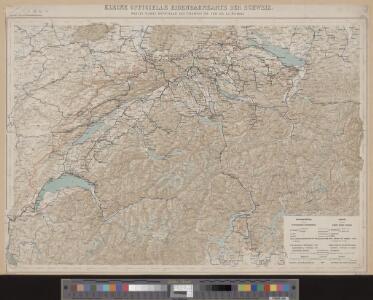
Kleine officielle Eisenbahnkarte der Schweiz
1 : 500000 1 Karte gest. von R. Leuzinger ; Schweizer. Post- und Eisenbahndepartement = Petite carte officielle des chemins de fer de la Suisse Kümmerly, Bern
Officielle Eisenbahnkarte der Schweiz
1 : 500000 1 Karte Schweizer. Post- und Eisenbahndepartement = Carte officielle des chemins de fer de la Suisse Kümmerly, Bern
Officielle Eisenbahnkarte der Schweiz
1 : 500000 1 Karte Kümmerly & Frey, Bern
Officielle Eisenbahnkarte der Schweiz
1 : 500000 1 Karte Schweizer. Post- und Eisenbahndepartement Kümmerly & Frey, Bern
Übersichtskarte der Schweizer-Alpen
1 : 700000 Verlag der J. Dalp'schen Buch & Kunsthandlung (Carl Schmid)
Eisenbahnen, Posten & Télégraphen Karte der Schweiz
1 : 850000 1 Karte F. Müllhaupt H. Müllhaupt u. Sohn, Bern
Officielle Eisenbahnkarte der Schweiz
1 : 500000 1 Karte Schweiz. Post- & Eisenbahndepartement = Carte officielle des chemins de fer de la Suisse Kümmerly, Bern
Officielle Eisenbahnkarte der Schweiz
1 : 500000 1 Karte Schweiz. Post- & Eisenbahndepartement = Carte officielle des chemins de fer de la Suisse Kümmerly & Frey, Bern
Officielle Eisenbahnkarte der Schweiz
1 : 500000 1 Karte Schweiz. Post- & Eisenbahndepartement = Carte officielle des chemins de fer de la Suisse Kümmerly, Bern
Kleine officielle Eisenbahnkarte der Schweiz
1 : 500000 1 Karte gest. von R. Leuzinger ; Schweizerisches Post- & Eisenbahndepartement Kümmerly, Bern
Eisenbahnen, Posten & Telegraphen-Karte der Schweiz
1 : 850000 1 Karte von F. Müllhaupt = Carte des chemins de fer, postes et télégraphes de la Suisse / par F. Müllhaupt Geographischer Verlag H. Müllhaupt u. Sohn, Bern
Helvetia, Rhaetia, Valesia
1 Karte labore et studio Henrici Ludovici Muoss Muoss, [Zug]
Carte industrielle de la Suisse pour l'année 1882
1 : 500000 1 Karte élaborée sur la demande du Comité Central de l'Exposition Nationale à Zurich par Hermann Schlatter = Industrie-Karte der Schweiz für das Jahr 1882 / im Auftrage des Central-Comite der schweiz. Landesausstellung in Zürich bearb. von Hermann Schlatter Wurster, Randegger & Co., Winterthur
Physikalische Karte der Schweiz
1 : 800000 1 Karte R. Leuzinger J. Dalp (C. Schmid), Bern
Carte de la Suisse
1 : 700000 1 Karte par W. Rosier ; Fernique, Ph. sc. Delachaux & Niestlé, Neuchâtel
Relief-Karte der Schweiz
1 : 530000 1 Karte von R. Leuzinger ; [Kartogr.:] Topogr. Anstalt v. Wurster, Randegger & Co. in Winterthur J. Wurster & Co., Zürich
Nova Helvetiae tabula geographica illustrissimis et potentissimis cantonibus et rebuspublicis reformatae religionis Tigurinae, Bernensi, Glaronensi, Basiliensi, Scaphusianae, Abbatis Cellanae
1 : 230000 1 Karte auf 4 Bl. dominis suis clementissimis humilime dicata a Ioh. Iacobo Scheuchzero Tigurino ; Ioh. Melch. Füsslin ornamenta pinx. ; Ioh. Henr. Huber et Eman. Schalch sculps. [Hofmeister], [Zürich]
Nova totius Helvetiae cum suis subditis ac sociis tab. geogr
1 : 790000 1 Karte studio manu ac sumtibus Matth. Seut. Seutter, [Augsburg]
Oro-hydrographische Karte der Schweiz
1 : 500000 1 Karte gest. v. Leuzinger u. v. Hoven Eidg. Stabsbureau, [Bern]
Karte der schweizerischen Nationalrathswahlkreise
1 : 500000 1 Karte C. v. Hoven lith. Kümmerly, Bern
Reise-Karte der Schweiz
1 : 400000 1 Karte Lithographie der Gebrd. Belliger = Carte routière de la Confédération Suisse : executée d'après les sources les meilleures et les plus récentes / lithographie des frères Belliger Belliger, Arau
Roadmap of Switzerland
1 : 400000 1 Karte dressée et gravée par Mullhaupt ; écrit par Bressanini ; publiée par H.F. Leuthold H.F. Leuthold, Zürich
Carte industrielle de la Suisse pour l'année 1882
1 : 500000 1 Karte élaborée sur la demande du Comité Central de l'Exposition Nationale à Zurich par Hermann Schlatter = Industrie-Karte der Schweiz für das Jahr 1882 / im Auftrage des Central-Comite der schweiz. Landesausstellung in Zürich bearb. von Hermann Schlatter Wurster, Randegger & Co., Winterthur
Neueste Eisenbahn-Karte der Schweiz
1 : 750000 1 Karte gezeichnet von A. Starklauf Verlag der lithographischen Anstalt u. Schablonenfabrikation von A.W. Fehrenbach, Zürich
Officielle Distanzen- und Höhen-Karte der schweizerischen Eisenbahnen
1 : 500000 1 Karte Schweiz. Post- und Eisenbahndepartement Kümmerly, Bern
Carte générale de la Suisse et de ses environs
1 Karte : Kupferdruck ; 40 x 56 cm Monti; Buache chez F. Monti
Carte de la Suisse pour les écoles
1 : 700000 1 Karte R. Leuzinger Verlag von Schmid, Francke & Co. vormals J. Dalp'sche Buchhandlung, Bern
Roadmap of Switzerland
1 : 400000 1 Karte dressée et gravée par Mullhaupt ; écrit par Bressanini ; publiée par H.F. Leuthold H.F. Leuthold, Zürich
[Schweiz]
1 : 1300000 1 Karte [von Jakob Friedrich Klemm] [Heerbrandt], [Tübingen]