Maps of Switzerland

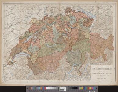
Karte der schweizerischen Nationalrathswahlkreise
1 : 500000 1 Karte C. v. Hoven lith. Kümmerly, Bern
Eisenbahnen, Posten & Telegraphen-Karte der Schweiz
1 : 850000 1 Karte von F. Müllhaupt = Carte des chemins de fer, postes et télégraphes de la Suisse : toutes les stations et les nouveaux projets de chemin de fer sont indiqués clairement / par F. Müllhaupt Geographischer Verlag von H. Müllhaupt & Sohn, Bern
Helvetia, Rhaetia, Valesia
1 Karte labore et studio Henrici Ludovici Muoss Muoss, [Zug]
Roadmap of Switzerland
1 : 400000 1 Karte dressée et gravée par Mullhaupt ; écrit par Bressanini ; publiée par H.F. Leuthold H.F. Leuthold, Zürich
Officielle Eisenbahnkarte der Schweiz
1 : 500000 1 Karte Schweiz. Post- & Eisenbahndepartement = Carte officielle des chemins de fer de la Suisse Kümmerly, Bern
Oro-hydrographische Karte der Schweiz
1 : 500000 1 Karte gest. v. Leuzinger u. v. Hoven Eidg. Stabsbureau, [Bern]
Roadmap of Switzerland
1 : 400000 1 Karte dressée et gravée par Mullhaupt ; écrit par Bressanini ; publiée par H.F. Leuthold H.F. Leuthold, Zürich
Carte de la Suisse pour les écoles
1 : 700000 1 Karte R. Leuzinger Verlag von Schmid & Francke, Bern
Roadmap of Switzerland
1 : 400000 1 Karte dressée et gravée par Mullhaupt ; écrit par Bressanini ; publiée par H.F. Leuthold H.F. Leuthold, Zürich
Carte industrielle de la Suisse pour l'année 1882
1 : 500000 1 Karte élaborée sur la demande du Comité Central de l'Exposition Nationale à Zurich par Hermann Schlatter = Industrie-Karte der Schweiz für das Jahr 1882 / im Auftrage des Central-Comite der schweiz. Landesausstellung in Zürich bearb. von Hermann Schlatter Wurster, Randegger & Co., Winterthur
Officielle Eisenbahnkarte der Schweiz
1 : 500000 1 Karte Schweizer. Post- und Eisenbahndepartement Kümmerly & Frey, Bern
Officielle Eisenbahnkarte der Schweiz
1 : 500000 1 Karte Schweiz. Post- & Eisenbahndepartement = Carte officielle des chemins de fer de la Suisse Kümmerly & Frey, Bern
Potentissimae Helvetiorum reipublicae cantones tredecim cum foederatis et subjectis provinciis
1 : 580000 1 Karte exhibiti a Joh. Baptista Homanno [Homännische Erben], Noribergae
<<Die>> Schweiz, oder, Helvetische Eidgenossenschaft
1 : 628000 1 Karte entworfen und gezeichnet von C. F. Weiland Im Verlage des Geograph. Instituts, Weimar
Helvetia cum subditis & sociis Helvet. ad usum temporis nostri
1 : 1000000 1 Karte Christ. Weigel excudente ; Michael Kauffer sculp. Weigel, Noribergae
Karte der Schweiz
1 : 800000 1 Karte R. Leuzinger J. Dalp'sche Buch & Kunsthandlung (C. Schmid), Bern
Officielle Eisenbahnkarte der Schweiz
1 : 500000 1 Karte Schweiz. Post- & Eisenbahndepartement = Carte officielle des chemins de fer de la Suisse Kümmerly, Bern
Roadmap of Switzerland
1 : 400000 1 Karte dressée et gravée par Mullhaupt ; écrit par Bressanini ; publiée par H.F. Leuthold H.F. Leuthold, Zürich
Petite carte de la Suisse pour les écoles
1 : 800000 1 Karte gezeichnet und herausgegeben von Heinrich Keller Keller, [Zürich]
Carte de la Suisse pour les écoles
1 : 700000 1 Karte R. Leuzinger Verlag von Schmid, Francke & Co. vormals J. Dalp'sche Buchhandlung, Bern
Relief-Karte der Schweiz
1 : 530000 1 Karte von R. Leuzinger ; [Kartogr.:] Topogr. Anstalt v. Wurster, Randegger & Co. in Winterthur J. Wurster & Co., Zürich
Kleine officielle Eisenbahnkarte der Schweiz
1 : 500000 1 Karte gest. von R. Leuzinger ; Schweizerisches Post- & Eisenbahndepartement Kümmerly, Bern
Eisenbahnen, Posten & Telegraphen-Karte der Schweiz
1 : 850000 1 Karte von F. Müllhaupt = Carte des chemins de fer, postes et télégraphes de la Suisse / par F. Müllhaupt Geographischer Verlag H. Müllhaupt u. Sohn, Bern
Officielle Eisenbahnkarte der Schweiz
1 : 500000 1 Karte Schweizer. Post- und Eisenbahndepartement = Carte officielle des chemins de fer de la Suisse Kümmerly, Bern
Carte industrielle de la Suisse pour l'année 1882
1 : 500000 1 Karte élaborée sur la demande du Comité Central de l'Exposition Nationale à Zurich par Hermann Schlatter = Industrie-Karte der Schweiz für das Jahr 1882 / im Auftrage des Central-Comite der schweiz. Landesausstellung in Zürich bearb. von Hermann Schlatter Wurster, Randegger & Co., Winterthur
Roadmap of Switzerland
1 : 400000 1 Karte dressée et gravée par Mullhaupt ; écrit par Bressanini ; publiée par H.F. Leuthold H.F. Leuthold, Zürich
<<Les>> Suisses, leurs sujets et leurs alliéz
1 Karte corrigée et augmentée d'après les nouvelles observations de Ms. de l'Académie Royale des Sciences ; P. Starckman sculpsit chez Desnos, Rue St. Jacques au Globe, Paris
Roadmap of Switzerland
1 : 400000 1 Karte dressée et gravée par Mullhaupt ; écrit par Bressanini ; publiée par H.F. Leuthold H.F. Leuthold, Zürich
Carte de la Suisse
1 : 700000 1 Karte par W. Rosier ; Fernique, Ph. sc. Delachaux & Niestlé, Neuchâtel