Maps of Switzerland

Carte industrielle de la Suisse pour l'année 1882
1 : 500000 1 Karte élaborée sur la demande du Comité Central de l'Exposition Nationale à Zurich par Hermann Schlatter = Industrie-Karte der Schweiz für das Jahr 1882 / im Auftrage des Central-Comite der schweiz. Landesausstellung in Zürich bearb. von Hermann Schlatter Wurster, Randegger & Co., Winterthur
Roadmap of Switzerland
1 : 400000 1 Karte dressée et gravée par Mullhaupt ; écrit par Bressanini ; publiée par H.F. Leuthold H.F. Leuthold, Zürich
Relief-Karte der Schweiz
1 : 530000 1 Karte von R. Leuzinger ; [Kartogr.:] Topogr. Anstalt v. Wurster, Randegger & Co. in Winterthur J. Wurster & Co., Zürich
Roadmap of Switzerland
1 : 400000 1 Karte dressée et gravée par Mullhaupt ; écrit par Bressanini ; publiée par H.F. Leuthold H.F. Leuthold, Zürich
Carte industrielle de la Suisse pour l'année 1882
1 : 500000 1 Karte élaborée sur la demande du Comité Central de l'Exposition Nationale à Zurich par Hermann Schlatter = Industrie-Karte der Schweiz für das Jahr 1882 / im Auftrage des Central-Comite der schweiz. Landesausstellung in Zürich bearb. von Hermann Schlatter Wurster, Randegger & Co., Winterthur
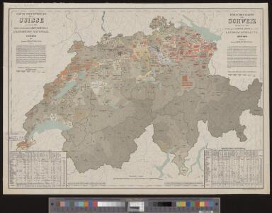
Karte der schweizerischen Nationalrathswahlkreise
1 : 500000 1 Karte C. v. Hoven lith. Kümmerly, Bern
Roadmap of Switzerland
1 : 400000 1 Karte dressée et gravée par Mullhaupt ; écrit par Bressanini ; publiée par H.F. Leuthold H.F. Leuthold, Zürich
Roadmap of Switzerland
1 : 400000 1 Karte dressée et gravée par Mullhaupt ; écrit par Bressanini ; publiée par H.F. Leuthold H.F. Leuthold, Zürich
Helvetia, Rhaetia, Valesia
1 Karte labore et studio Henrici Ludovici Muoss Muoss, [Zug]
Roadmap of Switzerland
1 : 400000 1 Karte dressée et gravée par Mullhaupt ; écrit par Bressanini ; publiée par H.F. Leuthold H.F. Leuthold, Zürich
Carte industrielle de la Suisse pour l'année 1882
1 : 500000 1 Karte élaborée sur la demande du Comité Central de l'Exposition Nationale à Zurich par Hermann Schlatter = Industrie-Karte der Schweiz für das Jahr 1882 / im Auftrage des Central-Comite der schweiz. Landesausstellung in Zürich bearb. von Hermann Schlatter Wurster, Randegger & Co., Winterthur
Roadmap of Switzerland
1 : 355000 1 Karte dressée et gravée par Mullhaupt ; écrit par Bressanini Leuthold, Zürich
Carte physique et routière de la Suisse
1 : 490000 1 Karte publiée par J. Andriveau-Goujon J. Andriveau-Goujon, Paris
Roadmap of Switzerland
1 : 400000 1 Karte dressée et gravée par Mullhaupt ; écrit par Bressanini ; publiée par H.F. Leuthold H.F. Leuthold, Zürich
Roadmap of Switzerland
1 : 400000 1 Karte dressée et gravée par Mullhaupt ; écrit par Bressanini ; publiée par H.F. Leuthold H.F. Leuthold, Zürich
Eisenbahnen, Posten & Telegraphen-Karte der Schweiz
1 : 850000 1 Karte von F. Müllhaupt = Carte des chemins de fer, postes et télégraphes de la Suisse : toutes les stations et les nouveaux projets de chemin de fer sont indiqués clairement / par F. Müllhaupt Geographischer Verlag von H. Müllhaupt & Sohn, Bern
Roadmap of Switzerland
1 : 355000 1 Karte dressée et gravée par Mullhaupt ; écrit par Bressanini Leuthold, Zürich
Roadmap of Switzerland
1 : 400000 1 Karte dressée et gravée par Mullhaupt ; écrit par Bressanini ; publiée par H.F. Leuthold H.F. Leuthold, Zürich
Reisekarte der Schweiz
1 : 355000 1 Karte dressée et gravée par Mullhaupt ; écrit par Bressanini Leuthold, Zürich
Roadmap of Switzerland
1 : 400000 1 Karte dressée et gravée par Mullhaupt ; écrit par Bressanini ; publiée par H.F. Leuthold H.F. Leuthold, Zürich
Officielle Uebersichtskarte der Schweiz. Eisenbahnen
1 : 800000 1 Karte J. Dalp'sche Buch & Kunsthandlung (Carl Schmid), Bern
Suisse
1 : 487000 1 Karte E. Andriveau-Goujon ; gravé: le trait par Smith, la topographie par Gérin, les écritures par P. Rousset, les eaux par Mme Fontaine Andriveau-Goujon, Paris
Kleine officielle Eisenbahnkarte der Schweiz
1 : 500000 1 Karte gest. von R. Leuzinger ; Schweizer. Post- und Eisenbahndepartement = Petite carte officielle des chemins de fer de la Suisse Kümmerly, Bern
Helvetia
1 : 1700000 1 Karte [excusum in aedibus Iudoci Hondij], [Amsterodami]
Karte der Schweiz für Schulen
1 : 800000 1 Karte von R. Leuzinger Verlag der J. Dalp'schen Buch & Kunsthandlung (Carl Schmid), Bern
<<Die>> Schweiz, oder, Helvetische Eidgenossenschaft
1 : 628000 1 Karte entworfen und gezeichnet von C. F. Weiland Im Verlage des Geograph. Instituts, Weimar
Reise-Karte der Schweiz
1 : 400000 1 Karte Lithographie der Gebrd. Belliger = Carte routière de la Confédération Suisse : executée d'après les sources les meilleures et les plus récentes / lithographie des frères Belliger Belliger, Arau
Officielle Eisenbahnkarte der Schweiz
1 : 500000 1 Karte Schweiz. Post- & Eisenbahndepartement = Carte officielle des chemins de fer de la Suisse Kümmerly, Bern
Helvetiae conterminarumque terrarum antiqua descriptio
1 : 1200000 1 Karte auctore Phil. Clüverio [Verlag nicht ermittelbar], [Wolfenbüttel]