Maps of Switzerland


Carte de la Suisse pour les écoles
1 : 700000 Leuzinger, Rudolf J. Dalp'sche Buch & Kunsthandlung
Carte de la Suisse pour les écoles
1 : 700000 Leuzinger, Rudolf J. Dalp'sche Buch und Kunsthandlung
Suisse or Switzerland.
1 : 1500000 Moll, Herman, d. 1732
Carte de Suisse
1 Karte dressée sur les mémoires de Merveilleux par Guillaume De l'Isle ; augmenté en 1759 par Phil. Buache chez l'auteur sur le Quay de l'Horloge, Paris
Charte von der Republik Schweiz
Neuester Schul-Atlas Walch, Johann im Verlag bei Joh. Walch
Die Schweiz.
1 : 800000 Andree, Richard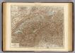
Switzerland.
1 : 800000 Andree, Richard; Times (London, England)
Switzerland.
1 : 1450000 Bowen, Frances
Exactissima Helvetiae, Rhaetiae, Valesiae caeterorumq. confoederatorum ut et finitimorum populorum regionum tabula
1 Karte ex conatibus Nicolai Visscher ; A. Hogeboom sculp. Visscher, [Amsterdam]
Karte der Schweiz
1 : 400000 1 Karte par R. Leuzinger Schmid & Francke, Berne
Helvetia cum finitimis regionibus confoederatis
1 : 800000 1 Karte per Gerardum Mercatorem [Mercator], [Duisburg]
Officielle Eisenbahn-Karte der Schweiz
1 : 250000 1 Karte gest. v. H. Müllhaupt Eidg. Stabsbureau, [Bern]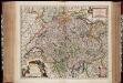
Exactissima Helvetiae Rhaetiae, Valesiae caeterorumq. confoederatorum ut et finitimorum populorum regionum tabula / ex conatibus Nicolaum Visscher Amst. Bat. ; A. Hogeboom sculp
1 : 800000 Annotatie: Cum privil. praepotentiss. Ordinum General. Belgii Foederati; Met opdracht van Nicolaus Visscher; Origineel is Blad 117 in atlas factice; Annotatie geografische gegevens: Met 5 schaalstokken; Legenda Nicolaes Jansz. Visscher jr. 1649-1702; Andries Hogeboom fl. 1665-1682 Amst. Bat. : ex conatibus Nicolai Visscher
Karte der Schweiz
1 : 400000 1 Karte bearbeitet nach Dufour = Carte de la Suisse / d'après la carte Dufour par R. Leuzinger Verlag der J. Dalp'schen Buchhandlung, Berne
Schweiz mit den projectirten Eisenbahnen
1 : 1200000 Joh. Wurster u. Comp.
Nouvelle carte de la Suisse dans laquelle sont exactement distingués les treize cantons, leurs alliés et leurs sujets
1 Karte dréssée sur les mémoires les plus corrects et assujettie aux observations astronomiques [par William Faden] chez W. Faden, Charing Cross, Londre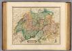
Switzerland.
1 : 760000 Lizars, Daniel
Switzerland.
1 : 950400 Colton, G.W.
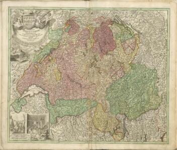
Nova Helvetiae tabula geographica illustrissimis et potentissimis cantonibus et rebuspublicis reformatae religionis Tigurinae, Bernensi, Glaronensi, Basiliensi, Scaphusianae, Abbatis Cellanae
1 : 320000 1 Karte auf 4 Bl. dominis suis clementissimis humilime dicata a Ioh. Iacobo Scheuchzero Tigurino ex officina Petri Schenckii, Amstelaedami
Karte der Schweiz
1 : 400000 1 Karte bearbeitet nach Dufour = Carte de la Suisse / d'après la carte Dufour par R. Leuzinger Propriété de la Librairie J. Dalp (Ch. Schmid), Berne
Nova Helvetiae, foederatarumque cum ea, nec non subditarum regionum tabula, ad usum serenissimi Burgundiae ducis, secundum commentarios domini Merveilleux
1 Karte composita per Guilielmum de l'Isle apud Joh. Covens & Corn. Mortier, Amstelodami
Karte der Schweiz
1 : 400000 1 Karte gezeichnet u. gestochen von R. Leuzinger in Bern ; Schrift von Ch. v. Hoven = Carte de la Suisse / par R. Leuzinger Verlag der Dalp'schen Buchhandlung, Berne
Karte der Schweiz
1 : 400000 1 Karte bearbeitet nach Dufour = Carte de la Suisse / d'après la carte Dufour par R. Leuzinger Schmid & Francke, vorm. J. Dalp'sche Buchhandlung, Bern
Helvetia cum finitimis regionibus confoederatis
1 : 800000 1 Karte per Gerardum Mercatorem [Mercator], [Duisburg]
Hypsometrische Karte der Schweiz
1 : 1200000 Wurster u. Comp.
Carte generale des treize cantons suisses, et des differents etats de leur dependance
1 Karte : Kupferdruck ; 41 x 48 cm Châtelain s.n.
[Schweiz]
1 : 530000 Leuzinger, Rudolf Schmid & Francke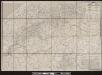
Karte der Posten, Telegraphen und Eisenbahnen der Schweizerischen Eidgenossenschaft
1 : 300000 1 Karte offizielle Ausgabe durch das Postdepartement nach dem eidgenössischen Atlasse = Carte des postes, des télégraphes et des chemins de fer de la Confédération Suisse / édititon officielle publiée par le Département des Postes d'après l'atlas fédéral Wurster, Winterthur