Maps of Switzerland
Suisse ou sont les Cantons.
1 : 514000 Merveilleux, David Francois de

Switzerland.
1 : 1280000 Mitchell, Samuel Augustus
[Recto], uit: Tourist map of Switzerland
1 : 600000 Berne [etc.] : Swiss National Tourist Office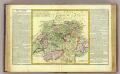
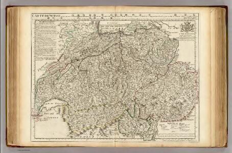
La Suisse.
1 : 980000 Clouet, J. B. L. (Jean-Baptiste Louis), b. 1730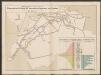
Graphisch-statistischer Atlas der Schweizerischen Normalbahnen
1 : 500000 Ursprüngliche, bis Ende 1881 berechnete Anlagekosten nach Strecken Schweizerische Nordostbahn Lithographie Druck & Verlag von Hofer & Burger
Carte genérale de la Suisse, oder, Die Helvetische Republik in XXII Cantone eingetheilt
1 : 525000 1 Karte Joh. Walch bei Joh. Walch, Augsburg
La Suisse
1 Karte : Kupferdruck ; 43 x 54 cm Bonne; Santini G. A. Remondini?
[Karte der Schweiz]
1 Karte : Kupferdruck ; 16 x 20 cm Heidegger; Halder s.n.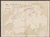
Graphisch-statistischer Atlas der Schweizerischen Normalbahnen
1 : 500000 Historische Entwicklung der Netze 1855 - 1882 Schweizerische Nordostbahn Lithographie Druck & Verlag von Hofer & Burger
Die Helvetische Republik in Cantone und Districte eingetheilt
1 Karte : Typometrie ; 36 x 49 cm Haas gedruckt bey Wilhelm Haas dem Sohne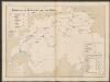
Graphisch-statistischer Atlas der Schweizerischen Normalbahnen
1 : 500000 Historische Entwicklung der Netze 1875 Schweizerische Nordostbahn Lithographie Druck & Verlag von Hofer & Burger
Carte physique & routière de la Suisse
1 : 500000 1 Karte dressés d'après des meilleurs matériaux par Jean Goll ; gravée par [Henri Louis Nicolas] Duval & [Rinaldo] Bressanini Henri Fuessli & Cie., Zürich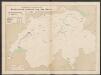
Graphisch-statistischer Atlas der Schweizerischen Normalbahnen
1 : 500000 Historische Entwicklung der Netze 1855 Schweizerische Nordostbahn Lithographie Druck & Verlag von Hofer & Burger
[Reliefkarte der Schweiz]
1 : 1500000 1 Karte Kümmerly & Frey, Bern
Karte der Schweiz
1 : 600000 1 Karte gez. u. gest. v. J. J. Scheurmann Orell Füssli & Comp., Zürich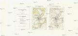
Carte nationale de la Suisse
1 : 25000 Švýcarsko Service topographique fédéral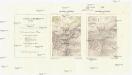
Landeskarte der Schweiz
1 : 25000 Švýcarsko Eidgenössische Landestopographie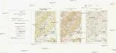
Carte nationale de la Suisse
1 : 50000 Švýcarsko Service topographique fédéral
[Carte topographique de la Suisse]
1 : 50000 Švýcarsko Service topographique féderal
[Carte della Suisse topografia]
1 : 50000 Švýcarsko Ufficio topografia federale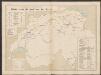
Graphisch-statistischer Atlas der Schweizerischen Normalbahnen
1 : 500000 Historische Entwicklung der Netze 1880 Schweizerische Nordostbahn Lithographie Druck & Verlag von Hofer & Burger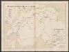
Graphisch-statistischer Atlas der Schweizerischen Normalbahnen
1 : 500000 Historische Entwicklung der Netze 1881 - 1882 Schweizerische Nordostbahn Lithographie Druck & Verlag von Hofer & Burger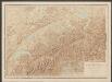
Relief-Karte der Schweiz
1 : 530000 Leuzinger, Rudolf Schmid, Francke
Karte der Fundorte von Rohproducten in der Schweiz
1 : 520000 1 Karte von Julius Weber und A. Brosi ; veröffentlicht auf Veranlassung des Schweizerischen Handels u. Landwirthschafts-Departements ; [Kartogr.:] Topogr. Anstalt v. Wurster, Randegger & Co. J. Wurster & Cie., Zürich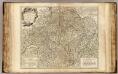
Suisses.
1 : 540000 Robert de Vaugondy, Gilles, 1688-1766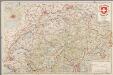
[Recto], uit: Carte du touriste de Suisse / Institut géograph de Kümmerly & Frey
1 : 600000 titelvariant: Suisse; Suisse: carte et guide; Annotatie: Titel op omslag: Suisse : Carte et Guide; Verso: toeristische informatie Kümmerly + Frey, Bern Zürich [etc.] : Office suisse du Tourisme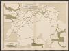
Graphisch-statistischer Atlas der Schweizerischen Normalbahnen
1 : 500000 Leistungen des Betriebsmaterials 1881 Schweizerische Nordostbahn Lithographie Druck & Verlag von Hofer & Burger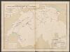
Graphisch-statistischer Atlas der Schweizerischen Normalbahnen
1 : 500000 Historische Entwicklung der Netze 1865 Schweizerische Nordostbahn Lithographie Druck & Verlag von Hofer & Burger