Maps of Massachusetts
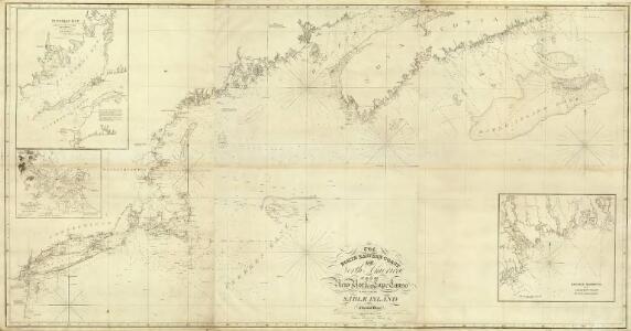
Composite: NE coast North America, N.Y. to Cape Canso.
1 : 910000 Wadsworth, A. S. (Alex. S.)
The north eastern coast of North America: from New York to Cape Canso, including Sable Island / by Edmunt Blunt, hydrographer; drawn & engraved by Charles Copley, N.Y.
from Parts Edmund Blunt; Charles Copley,
Carte réduite des côtes orientales de l'Amérique septentrionale: contenant celles des provinces de New-York et de la Nouvelle Angleterre, celles de l'Acadie ou Nouvelle Ecosse, de l'Île Royale de l'Île St. Jean, avec l'intérieur du pays dressée au Dépôt général des cartes, plans et journaux de la marine, pour le service des vaisseaux du roi, par ordre de M. de Sartine, conseiller d'Etat, ministre et secretaire d'Etat ayant le département de la marine / Petit, sculp.
from John H. Levine Collection M. de Sartine,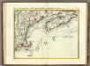
L'Acadia, le Provincie di Sagadahook e Main, la Nuova Hampshire.
1 : 2100000 Zatta, Antonio
Tierra nveva.
from Charts and maps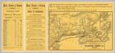
Intl. Steamship Co.'s routes.
1 : 3244000 International Steamship Company
New England.
1 : 2550000 Huntington, Nathaniel G. (Nathaniel Gilbert), 1785-1848
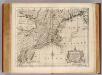
A new and accurate map of New Jersey, Pensilvania, New York and New England: with the adjacent countries / drawn from surveys, assisted by the most approved modern maps & charts and regulated by astronomical observations by Eman. Bowen.
from Charts and maps Emannuel Bowen,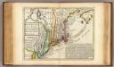
New England, New York, New Jersey and Pensilvania.
1 : 3700000 Moll, Herman, d. 1732
New Engelland, New York, New Yersey und Pensilvania
N.J., Pa., N.Y. & New England.
1 : 2200000 Bowen, Emanuel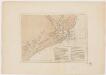
Charts of the coast and harbors of New England : from surveys taken by Saml. Holland Esqr. Survr. Genr. of Lands for the Northern District of North America and Geo. Sproule, Chas. Blaskowitz, Jam.s Grant and Thos. Wheeler his assistants : Coast of Charleston, South Carolina
Des Barres, Joseph F. W. (Joseph Frederick Wallet), 1722-1824 J.F.W. Des Barres
Charts of the coast and harbors of New England : from surveys taken by Saml. Holland Esqr. Survr. Genr. of Lands for the Northern District of North America and Geo. Sproule, Chas. Blaskowitz, Jam.s Grant and Thos. Wheeler his assistants : Portions of the Hudson River
Des Barres, Joseph F. W. (Joseph Frederick Wallet), 1722-1824 J.F.W. Des Barres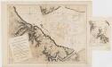
Charts of the coast and harbors of New England : from surveys taken by Saml. Holland Esqr. Survr. Genr. of Lands for the Northern District of North America and Geo. Sproule, Chas. Blaskowitz, Jam.s Grant and Thos. Wheeler his assistants : Portion of the Virginia Coast
Des Barres, Joseph F. W. (Joseph Frederick Wallet), 1722-1824 J.F.W. Des Barres
Charts of the coast and harbors of New England : from surveys taken by Saml. Holland Esqr. Survr. Genr. of Lands for the Northern District of North America and Geo. Sproule, Chas. Blaskowitz, Jam.s Grant and Thos. Wheeler his assistants : Harbor of Rhode Island and Narragansett Bay
Des Barres, Joseph F. W. (Joseph Frederick Wallet), 1722-1824 J.F.W. Des Barres
Charts of the coast and harbors of New England : from surveys taken by Saml. Holland Esqr. Survr. Genr. of Lands for the Northern District of North America and Geo. Sproule, Chas. Blaskowitz, Jam.s Grant and Thos. Wheeler his assistants : Charleston Harbor, South Carolina
Des Barres, Joseph F. W. (Joseph Frederick Wallet), 1722-1824 J.F.W. Des Barres
Charts of the coast and harbors of New England : from surveys taken by Saml. Holland Esqr. Survr. Genr. of Lands for the Northern District of North America and Geo. Sproule, Chas. Blaskowitz, Jam.s Grant and Thos. Wheeler his assistants : Hudson River
Des Barres, Joseph F. W. (Joseph Frederick Wallet), 1722-1824 J.F.W. Des Barres
Charts of the coast and harbors of New England : from surveys taken by Saml. Holland Esqr. Survr. Genr. of Lands for the Northern District of North America and Geo. Sproule, Chas. Blaskowitz, Jam.s Grant and Thos. Wheeler his assistants : Delaware River
Des Barres, Joseph F. W. (Joseph Frederick Wallet), 1722-1824 J.F.W. Des Barres
Charts of the coast and harbors of New England : from surveys taken by Saml. Holland Esqr. Survr. Genr. of Lands for the Northern District of North America and Geo. Sproule, Chas. Blaskowitz, Jam.s Grant and Thos. Wheeler his assistants : Georgia Coast
Des Barres, Joseph F. W. (Joseph Frederick Wallet), 1722-1824 J.F.W. Des Barres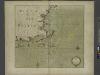
Part of NEW ENGLAND
from The sea-atlas : containing an hydrographical description of most of the sea-coasts of the known parts of the world.
Telegraph and rail road map of the New England states

Williams' telegraph and rail road map of the New England states, eastern portion of New York state and Canada

The colonies in 1660, New England and New Netherland showing extent and dates of settlement
1 : 3000000 Myers, Albert Cook Burrows Brothers Company
Map of New England exhibiting the rail and telegraphic lines now in operation
Brown & Hastings Coolidge & Wiley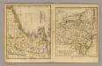
New England, Middle States.
Adams, Daniel
Map of Maine, New Hampshire, and Vermont : compiled from the latest authorities
1 : 1001000 Young, J. H. (James Hamilton) S. Augustus Mitchell
The north eastern coast, North America, New York to Cape Canso (east sheet)
1 : 910000 Des Barres, Joseph F. W. (Joseph Frederick Wallet), 1722-1824
New England.
1 : 2700000 Cornell, S. S. (Sarah S.)
New England.
1 : 3600000 Grigg, John