Maps of Maine
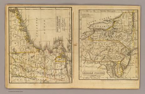
New England, Middle States.
Adams, Daniel
Map of the New England or Eastern States.
1 : 3000000 Mitchell, Samuel Augustus
New England.
1 : 2550000 Huntington, Nathaniel G. (Nathaniel Gilbert), 1785-1848
Telegraph and rail road map of the New England states

Williams' telegraph and rail road map of the New England states, eastern portion of New York state and Canada

New England.
1 : 2700000 Cornell, S. S. (Sarah S.)
New England.
1 : 3600000 Grigg, John
Maine. New Hampshire.
1 : 1250000 Gray, Ormando Willis
New England And Lower Canada.
1 : 1520640 Johnson, A.J.
[Map of New England, 31st]

Map of the northern, or, New England states of America, comprehending Vermont, New Hampshire, District of Main, Massachusetts, Rhode Island, and Connecticut

States of Maine, New Hampshire, Vermont, Massachusetts, Connecticut, & Rhode Island.
1 : 1110000 Tanner, Henry S.
Map New England

G. Woolworth Colton's railroad, township & distance map of New England with adjacent portions of New York, Canada & New Brunswick
1 : 900000 Colton, G. Woolworth Colton, G. Woolworth
Map of New England

Maine, New Hampshire, Vermont, Massachusetts, Connecticut & Rhode Island.
1 : 1140480 Tanner, Henry S.
Map Of The States Of Maine, New Hampshire, Vermont, Massachusetts, Connecticut & Rhode Island.
1 : 1140480 Tanner, Henry S.
Maine, New Hampshire, Vermont, Massachusetts, Connecticut & Rhode Island.
1 : 1140480 Tanner, Henry S.
Maine, New Hampshire, Vermont, Massachusetts, Connecticut & Rhode Island.
1 : 1140480 Tanner, Henry S.
Maine, New Hampshire, Vermont, Massachusetts, Connecticut & Rhode Island.
1 : 1140480 Tanner, Henry S.
The New England states and part of Canada

New England.
1 : 1330560 Cram Atlas Company
Map of Maine, New Hampshire, Vermont, Massachusetts, Rhode Island, and Connecticut.
1 : 633600 Burr, David H., 1803-1875
New England States.
1 : 2250000 Huntington, Hezekiah, 1795-1865
Map of New England, with adjacent portions of New York & Canada

Map of New England with adjacent portions of New York & Canada
1 : 1537500 Walling, Henry Francis Walling, Henry Francis
A map of the New England states : Maine, New Hampshire, Vermont, Massachusetts, Rhode Island & Connecticut, with the adjacent parts of New York & lower Canada
1 : 506880 Hale, Nathan, 1784-1863 Nathan Hale
New England.
1 : 1550000 Walling, H. F.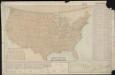
Parcel post map of the United States
1 : 7800000 L.L. Poates Engr'g Co. L.L. Poates Engr'g Co.