Maps of Metropolitan France

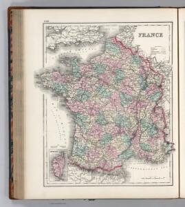
France.
1 : 3065000 Colton, G. Woolworth
Frankreich.
1 : 4700000 Reichard, C. G.
Carte des postes de France
1 Karte : Kupferdruck ; 64 x 54 cm Jean; Mondhare chez Mondhare et Jean rue St. Jean de Beauvais n.o 4
Tableau de la France
1 Karte : Kupferdruck ; 48 x 50 cm Dupain-Triel; Cassini de Thury chez l'auteur rue des Noyers St. Jacques près St. Yves
France.
1 : 1964160 Arrowsmith, John
Charte von Frankreich
1 : 2090000 Francie Weiland, Karl Ferdinand Beyer, Leonh. im Verlage des Geogr. Instituts
Kaiserthum Frankreich

Frankreich.
1 : 3500000 Radefeld, Carl Christian Franz, 1788-1874
France.
1 : 3200000 Mitchell, Samuel Augustus
France.
1 : 3200000 Mitchell, Samuel Augustus
France. Pergamon World Atlas.
1 : 2500000 Polish Army Topography Service
France (Republique Francaise). Pergamon World Atlas.
Polish Army Topography Service
France.
1 : 2476000 Hammond, C.S.
Carte de la France divisée en ses LXXXIII départements
1 : 2580000 Francie par les freres Lotter
France.
1 : 2232000 Johnston, Alexander Keith, 1804-1871
Les routes exactes des postes du royaume de France
1 Karte : Kupferdruck ; 42 x 49 cm, Bildgrösse: 45 x 58 cm Seutter; Lotter aux depens Tob. Conr. Lotter geogr
Les routes exactes des postes du royaume de France
1 Karte : Kupferdruck ; 42 x 49 cm Seutter s.n.
Les routes exactes des postes du royaume de France
1 Karte : Kupferdruck ; 42 x 49 cm Seutter; Lotter aux depens Tob. Conr. Lotter geogr
Frankreich
Plastischer Schul-Atlas über alle Theile der Erde : in 24 Karten Woldermann, G Verlag von P. Eckerlein
France Politique.
1 : 2500000 Vivien St Martin, L.
Carte Particuliere Des Postes De France [Karte], in: Atlas nouveau, contenant toutes les parties du monde [...], Bd. 1, S. 147.
1 Karte aus Atlas Sanson, Nicolas Jaillot, Alexis Hubert und Mortier, Pieter
Frankreich mit besonderer Rücksicht auf die Unebenheiten
1 : 20000000 Francie Berghaus, Heinrich Karl Wilhelm Brose, Heinr. im Magazin für Kunst, Geographie und Musik
Jeu géographique de la République Française
Francie Mauborgne, J. N. Basset Baßet
Carte de la France divisée en ses 83. départemens
1 : 3500000 Francie Vignon Bureau de l'Atlas national de France
Carte de la France divisée en ses 83. départemens
1 : 3500000 Francie
Géographie et statistique de la République française
1 : 1500000 par H. Langlois Paris : au Bureau Géographique
France.
1 : 3200000 Tanner, Henry S.
Frontiere du Sud-Est de la France.
1 : 1650000 Jouvet et Cie.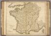
France.
1 : 1220000 Playfair, Principal