Maps of Metropolitan France

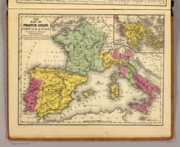
France, Spain, Portugal, Italy.
1 : 9200000 Mitchell, Samuel Augustus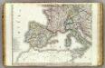
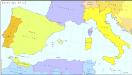
Europe 3.
1 : 3850000 Brue, Adrien Hubert, 1786-1832
[Ethnographische Karte von Europa]
Zweiter Band, enthaltend in vier Abtheilungen die Vertheilung der Organismen: 5. Pflanzen-Geographie, 6. Thier-Geographie, 7. Anthropographie, 8. Ethnographie Humboldt, Alexander von Verlag von Justus Perthes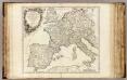
Imper. Caroli Magni.
1 : 5000000 Robert de Vaugondy, Gilles, 1688-1766
Western part of the mediterranean sea with the coasts of Spain France Italy Barbary
1 Blatt : 53 x 68 cm Sayer
Karte von Europa, 3
4 Blätter : 53 x 70 cm Verlag der Königlich-Preussischen Academie-Kunst- und Buchhandlung
Západní Evropa při konci XIV. věku

Carte des routes de postes de l'Empire francais du royaume d'Italie et de la Confédération du Rhin
Evropa západní Tardieu, Pierre François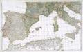
Prémière partie de la carte d'Europe contenant la France, l'Alemagne, l'Italie, l'Espagne & les isles britanniq.s, 2
1 Blatt : 53 x 85 cm s.n.
Karten - Skizzen für die Schul - Praxis

Imperii Romani, distracta
1 : 22200000 Evropa střední Bonne, Rigobert André
Orbis Romani pars occidentalis
1 : 10600000 Evropa západní Anville, Jean-Baptiste Bourguinon d' Küffner, Paul in officina Weigelia-Schneideriana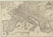
Imperium Caroli Magni
1 : 7400000 Mollova mapová sbírka Janssonius, Johannes Janssonius, Johannes I
Partie occidentale de la mer Méditerranée
1 Karte : Kupferdruck ; 49 x 55 cm Robert de Vaugondy Didier Robert de Vaugondy
West- u. Mittel- Europa im Zeitalter Napoleons (bis 1810)
Evropa střední F. Tempsky
Imperium Romanum
1 : 11100000 Evropa západní Bonne, Rigobert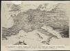
Stannard & Son's, panoramic birds-eye view of France & Prussia and the surrounding countries likely to be involved in the War, with the railways & startegic positions of each army, & the great fortresses of the Rhine provinces
1 : 1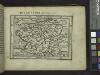
Gallia.
from Abraham Ortelius his epitome of the theater of the worlde / nowe latlye ... renewed and augmented ... by Micheal Coignet, mathematitian of Antwarpe.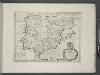
Spain and Portugal.
from A new sett of maps both of antient and present geography : wherein not only the latitude and longitude of many places are corrected according to the latest observations, but also the most remarkable differences of antient and present geography may be quickly discern'd by a bare inspection or comparing of correspondent maps, which seems to be the most natural and easy method to lead young students (for whose use the work is principally intended) unto a competent knowledge of the geographical science : together with a geographical treatise particularly adapted to the use and design of these maps / by Edward Wells, M.A. and student of Christ-Church, Oxon.

Orbis Romani pars occidentalis, auspiciis serenissimi principis Ludovici Philippi Aurelianorum ducis publici juris facta
1 : 4300000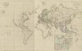
XI. Charte für die allgemeine Geschichte von der Selbstregierung Ludwig XIV. bis auf den österreichischen Erbfolgekrieg : d.i. von 1661 bis 1740 n. Christus
Entworfen von F.W. Benicken A. Falger gr. Weimar : im Verlage des L. Industrie-Comptoirs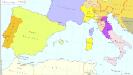
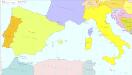
Südeuropa 1829
Südeuropa Kunz, Andreas ; Röss, Wolf ; Johnen, Bettina ; Moeschl, Joachim Robert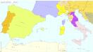
Südeuropa 1820
Südeuropa Kunz, Andreas ; Röss, Wolf ; Johnen, Bettina ; Moeschl, Joachim Robert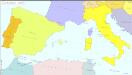
Südeuropa 1962
Südeuropa Kunz, Andreas ; Treiling, Thomas
Atlas für Handel und Industrie: Für Kaufleute, Fabrikante u. Gewerbetreibende, Handlungs- u. Gewerbe-Schulen
Südeuropa 2003
Südeuropa Kunz, Andreas ; Treiling, Thomas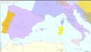
Südeuropa 1810
Südeuropa Kunz, Andreas ; Treiling, Thomas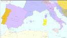
Südeuropa 1812
Südeuropa Kunz, Andreas ; Treiling, Thomas