Maps of Metropolitan France
Europe 3.
1 : 3850000 Brue, Adrien Hubert, 1786-1832
[Ethnographische Karte von Europa]
Zweiter Band, enthaltend in vier Abtheilungen die Vertheilung der Organismen: 5. Pflanzen-Geographie, 6. Thier-Geographie, 7. Anthropographie, 8. Ethnographie Humboldt, Alexander von Verlag von Justus Perthes
Západní Evropa při konci XIV. věku

Karte von Europa, 3
4 Blätter : 53 x 70 cm Verlag der Königlich-Preussischen Academie-Kunst- und Buchhandlung
Imper. Caroli Magni.
1 : 5000000 Robert de Vaugondy, Gilles, 1688-1766
Carte des routes de postes de l'Empire francais du royaume d'Italie et de la Confédération du Rhin
Evropa západní Tardieu, Pierre François
Orbis Romani, pars occidentalis.
1 : 4300000 Anville, Jean Baptiste Bourguignon d, 1697-1782
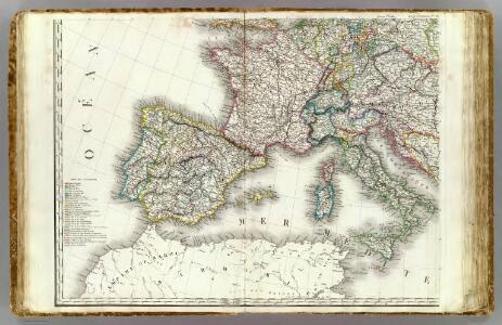
France, Spain, Portugal, Italy.
1 : 9200000 Mitchell, Samuel Augustus
West- u. Mittel- Europa im Zeitalter Napoleons (bis 1810)
Evropa střední F. Tempsky
Europa zur Zeit Napoleons
Europa Napoleon I., Frankreich, Kaiser
Orbis Romani Pars Occidentalis.
1 : 10137600 Lucas, Fielding Jr.
Spain and Portugal.
from New & accurate description of the earth in all its empires, kingdoms and states
West-Europa
1 : 3000000 Evropa západní Georg Westermann
Imperii Romani, distracta
1 : 22200000 Evropa střední Bonne, Rigobert André
Western Europe - communications.
1 : 5300000 John Bartholomew and Son
Europe 1.
1 : 2800000 Anville, Jean Baptiste Bourguignon d, 1697-1782
Orbis Romani pars occidentalis
1 : 10600000 Evropa západní Anville, Jean-Baptiste Bourguinon d' Küffner, Paul in officina Weigelia-Schneideriana
Carte de la Germanie et les diferents etats ou ses peuples ont porté leurs conquestes
Evropa jižní Chatelain, Henri-Abraham Chatelain
Centraal-, West-, en Zuid-Europa
1 : 3700000 [S.l. : s.n.]
Europe, intermediate century.
1 : 22500000 Fenner, Rest.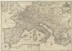
Imperium Caroli Magni
1 : 7400000 Mollova mapová sbírka Janssonius, Johannes Janssonius, Johannes I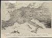
Stannard & Son's, panoramic birds-eye view of France & Prussia and the surrounding countries likely to be involved in the War, with the railways & startegic positions of each army, & the great fortresses of the Rhine provinces
1 : 1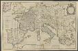
IMPERII | CAROLI MAGNI | et vicinarum regionum | DESCRIPTIO, | Dedicata et inscripta | LVDOVICO, | REGI, VICTORI, | ET DEFENSORI ECCLESIÆ | CHRISTI
ab Auctore Petro Bertio | ejusdem Cosmographo. [Amsterdam : Joan Blaeu]
Orbis Romani, occidentalis.
1 : 11500000 Anville, Jean Baptiste Bourguignon d, 1697-1782; M'Dermut, Robert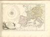

Orbis Romani pars occidentalis
1 : 10000000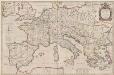
Imperii Caroli Magni et vicinarum regionum Descriptio [Karte], in: Theatrum orbis terrarum, sive, Atlas novus, Bd. 2, S. 167.
1 Karte aus Atlas Blaeu, Joan Blaeu, Willem Janszoon
Imperium Romanum
1 : 11100000 Evropa západní Bonne, Rigobert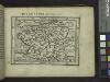
Gallia.
from Abraham Ortelius his epitome of the theater of the worlde / nowe latlye ... renewed and augmented ... by Micheal Coignet, mathematitian of Antwarpe.