Maps of Metropolitan France
XI. Charte für die allgemeine Geschichte von der Selbstregierung Ludwig XIV. bis auf den österreichischen Erbfolgekrieg : d.i. von 1661 bis 1740 n. Christus
Entworfen von F.W. Benicken A. Falger gr. Weimar : im Verlage des L. Industrie-Comptoirs
Western Europe.
1 : 7303000 Fisher, Richard Swainson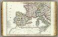
Europe 3.
1 : 3850000 Brue, Adrien Hubert, 1786-1832
Map of France, Spain, and Portugal; Switzerland in cantons [inset]; Island of Corsica [inset].
from Mitchell's new general atlas, containing maps of the various countries of the world, plans of cities, etc., embraced in fifty-three quarto maps., forming a series of eighty four maps and plans, together with valuable statistical tables.
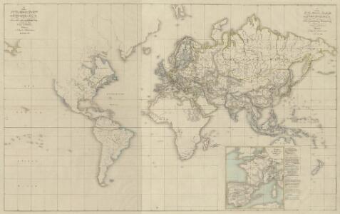
[Ethnographische Karte von Europa]
Zweiter Band, enthaltend in vier Abtheilungen die Vertheilung der Organismen: 5. Pflanzen-Geographie, 6. Thier-Geographie, 7. Anthropographie, 8. Ethnographie Humboldt, Alexander von Verlag von Justus Perthes
France, Spain, and Portugal.
1 : 3650000 Johnson, A.J.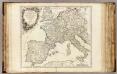
Imper. Caroli Magni.
1 : 5000000 Robert de Vaugondy, Gilles, 1688-1766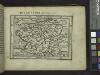
Gallia.
from Abraham Ortelius his epitome of the theater of the worlde / nowe latlye ... renewed and augmented ... by Micheal Coignet, mathematitian of Antwarpe.
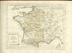
France.
from A new systeme of the mathematicks: containing I. Arithmetick, as well natural and decimal, as in species, or the principles of algebra. II. Practical geometry, together with the first six books of Euclid's Elements, as also the eleventh and twelfth, symbo
Západní Evropa při konci XIV. věku

Carte des routes de postes de l'Empire francais du royaume d'Italie et de la Confédération du Rhin
Evropa západní Tardieu, Pierre François
France, Spain, Portugal, Italy.
1 : 9200000 Mitchell, Samuel Augustus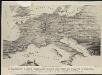
Stannard & Son's, panoramic birds-eye view of France & Prussia and the surrounding countries likely to be involved in the War, with the railways & startegic positions of each army, & the great fortresses of the Rhine provinces
1 : 1
France, Spain, and Portugal.
1 : 3658000 Johnson, A.J.
Gallia IIII. Nova Tabula [Karte], in: Geographia universalis vetus et nova complectens Claudii Ptolemaei Alexandrini enarrationis libros VIII, S. 311.
1 Karte aus Atlas Münster, Sebastian [und Ptolemaeus, Claudius]
Carte aéronautique de France
Service Géographique de l'Armée
Western part of the mediterranean sea with the coasts of Spain France Italy Barbary
1 Blatt : 53 x 68 cm Sayer
France, Spain, and Portugal.
1 : 3650000 Johnson, A.J.
France, Spain, and Portugal.
1 : 3650000 Johnson, A.J.
Tabula Europae III. [Karte], in: Claud. Ptolemaeus. Geographia lat. cum mappis [...], S. 260.
1 Karte aus Atlas Münster, Sebastian [und Ptolemaeus, Claudius]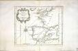
Carte des costes de France et d'Espagne
1 Karte : Kupferdruck ; 21 x 26 cm Bellin Arkstée et Merkus
Jak vzniká mapa
Tercia Europe Tabula [Gallia] [Karte], in: Claudii Ptolemei viri Alexandrini mathematice discipline philosophi doctissimi geographie opus [...], S. 157.
1 Karte aus Atlas Waldseemüller, Martin [und Ptolemaeus, Claudius] Übelin, Georg
Gallia IIII. Nova Tabula [Karte], in: Claud. Ptolemaeus. Geographia lat. cum mappis [...], S. 341.
1 Karte aus Atlas Münster, Sebastian [und Ptolemaeus, Claudius]
Tercia Europe Tabula [Karte], in: [Clavdii Ptholomei Cosmographi ...], S. 254.
1 Karte aus Atlas Nicolaus Germanus [und Ptolemaeus, Claudius]
Tabula Europae III. [Karte], in: Geographia universalis vetus et nova complectens Claudii Ptolemaei Alexandrini enarrationis libros VIII, S. 228.
1 Karte aus Atlas Münster, Sebastian [und Ptolemaeus, Claudius]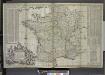
A new and exact map of France divided into all its provinces and acquisitions, ...
from The world described, or, A new and correct sett of maps : shewing the kingdoms and states in all the known parts of the earth, with the principal cities, and most considerable towns in the world ... / ... by Herman Moll, geographer ...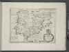
Spain and Portugal.
from A new sett of maps both of antient and present geography : wherein not only the latitude and longitude of many places are corrected according to the latest observations, but also the most remarkable differences of antient and present geography may be quickly discern'd by a bare inspection or comparing of correspondent maps, which seems to be the most natural and easy method to lead young students (for whose use the work is principally intended) unto a competent knowledge of the geographical science : together with a geographical treatise particularly adapted to the use and design of these maps / by Edward Wells, M.A. and student of Christ-Church, Oxon.
Tabula Moderna Gallie [Karte], in: Claudii Ptolemei viri Alexandrini mathematice discipline philosophi doctissimi geographie opus [...], S. 242.
1 Karte aus Atlas Waldseemüller, Martin [und Ptolemaeus, Claudius] Übelin, Georg