Maps of Richmond County

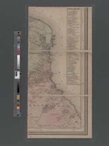
Map of Staten Island, Richmond County, New York City, from surveys under the direction of H. F. Walling.
From Staten Island
Part of Clifton.
from Atlas of Staten Island, Richmond County, New York, from official records and surveys; compiled and drawn by F. W. Beers.
21D - N.Y. City (Aerial Set).
from Sectional aerial maps of the City of New York / [photographed and assembled under the direction of the chief engineer, July 1st, 1924].
21B - N.Y. City (Aerial Set).
from Sectional aerial maps of the City of New York / [photographed and assembled under the direction of the chief engineer, July 1st, 1924].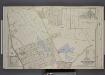
Part of Ward 4. [Map bound by Fox Hill Golf Links, Oak St, Virginia Ave, Clifton Ave, Pennsylvania Ave, Maryland Ave, Fingerboard Road, Clove Ave, Richmond Road, Vanderbilt Ave; Map bound by DeKalb, Danube Ave, Clove Ave, Richmond Road]
from Atlas of the borough of Richmond, city of New York.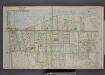
Part of Ward 4. [Map bound by Pier Line, New York Ave, Lyman Ave, Fingerboard Road, Fletcher St, Oak St, Fox Hill Golf Links, Vanderbilt Ave]
from Atlas of the borough of Richmond, city of New York.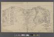
Map of New Brighton, Staten Island [cartographic material] : 1st, 2nd and 3rd wards.
From Staten Island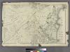
Section 8.
from Atlas of Staten Island, Richmond County, New York, from official records and surveys; compiled and drawn by F. W. Beers.
Section 9
from Atlas of Staten Island, Richmond County, New York, from official records and surveys; compiled and drawn by F. W. Beers.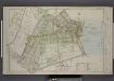
Part of Ward 2. [Map bound by Eddy St, Howard Ave, Trossach Road, St. Pauls Ave, Richmond Road, Beach St, Union PL, Cross St, Bulkhead Line, Vanderbilt Ave, Irving PL, Woodside Ave]
from Atlas of the borough of Richmond, city of New York.
Part of New Brighton : Town of Castleton.
from Atlas of Staten Island, Richmond County, New York, from official records and surveys; compiled and drawn by F. W. Beers.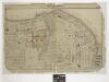
Part of New Brighton : Town of Castleton.
From Atlas of Staten Island, Richmond County, New York, from official records and surveys; compiled and drawn by F. W. Beers.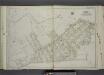
Part of Ward 2. [Map bound by Serpentine Road, Howard Ave (Serpentine RD) , Broad St, Gordon St, Tompkins St (Serpentine RD), Warren St, Pleasant PL, Vanderbilt Ave, Richmond Road, Northcole Ave, Cedar Terrace]
from Atlas of the city of New York, borough of Richmond, Staten Island. From actual surveys and original plans, by George W. and Walter S. Bromley.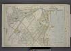
Part of Wards 1 & 2. [Map bound by Brighton Ave, York Ave, Second Ave, Westervelt Ave, Arrietta St, Pier Line, Front St, Cross St, Union St, Beach St, Richmond Road, Stone St, Trossach Road, Howard Ave, Richmond Turnpike, Woodstock Ave, Glen Ave]
from Atlas of the borough of Richmond, city of New York.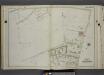
Part of Ward 4. [Map bound by Richmond Road, Vanderbilt Ave, Tompkins Ave (Centre St), Clifton Ave, Fletcher St, Wall St, Staten Island Rail Road, Pond, Targee St (Simonson PL)]
from Atlas of the city of New York, borough of Richmond, Staten Island. From actual surveys and original plans, by George W. and Walter S. Bromley.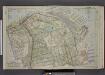
Part of Ward 1. [Map bound by Kill Van Kull, Pier Head of 1889 & 1904, Arrietta St, First Ave, Westervelt Ave, Second Ave, York Ave, Eleventh St, Prospect Ave, Franklin Ave]
from Atlas of the borough of Richmond, city of New York.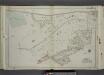
Part of Ward 2. [Map bound by Richmond Turnpike, Austin PL, Occident Ave, St. Pauls Ave, Stone St, Targee St, Purroy St (Elm St), Gordon St, Broad St, Howard Ave (Serpentine RD), Eddy St, Duncan Ave, Thressea PL]
from Atlas of the city of New York, borough of Richmond, Staten Island. From actual surveys and original plans, by George W. and Walter S. Bromley.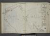
Part of Ward 4. [Map bound by Mosel Ave, Staten Island Rail Road, Rockwell Ave, Pennsylvania Ave, Clifton Ave, Tompkins Ave, Fingerboard Road, Grant Ave, Sherman Ave, Clover Ave]
from Atlas of the city of New York, borough of Richmond, Staten Island. From actual surveys and original plans, by George W. and Walter S. Bromley.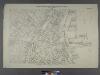
Borough of Richmond, Topographical Survey.
from Borough of Richmond, Topographical Survey.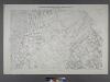
Borough of Richmond, Topographical Survey.
from Borough of Richmond, Topographical Survey.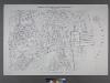
Borough of Richmond, Topographical Survey.
from Borough of Richmond, Topographical Survey.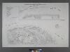
Borough of Richmond, Topographical Survey.
from Borough of Richmond, Topographical Survey.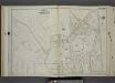
Part of Ward 4. [Map bound by Fingerboard Road, Sherman Ave, Grant Ave, Tompkins Ave, Richmond Ave, Sand Lane]
from Atlas of the city of New York, borough of Richmond, Staten Island. From actual surveys and original plans, by George W. and Walter S. Bromley.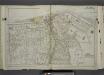
Part of Ward 1. [Map bound by Pierhead Line, Richmond Terrace, Nicholas St, St. Marks PL, Hamilton Ave, Daniel Low Terrace, Fort PL, Taft Ave (6th Ave), Jersey St, Pauw St (Center), York Ave, Prospect Ave, La Fayette Ave]
from Atlas of the city of New York, borough of Richmond, Staten Island. From actual surveys and original plans, by George W. and Walter S. Bromley.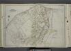
Part of Ward 2. [Map bound by Richmond Turnpike, Arriette St, Bulkhead Line, Bay St (Griffin St), Congress St, Van Duzer St (Richmond RD), Sands St, Wave St, Beach St, St. Pauls Ave, Occident Ave, Ward Ave, Austin PL (St)]
from Atlas of the city of New York, borough of Richmond, Staten Island. From actual surveys and original plans, by George W. and Walter S. Bromley.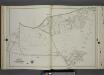
Part of Ward 4. [Map bound by Richmond Road, Baltic Ave, Hanover Ave (Main), Neckar Ave, Weser Ave, Elbe Ave, Mosel Ave, Clove Ave, Fingerboard Road, Staten Island Rail Road, Cornelia St, Wilson St, Old Town Road]
from Atlas of the city of New York, borough of Richmond, Staten Island. From actual surveys and original plans, by George W. and Walter S. Bromley.
Sheet No. 41. [Includes Fingerboard Road, Old Town Road in Grasmere, Chicago Avenue, Sand Lane, Pickersgill Avenue & Cleveland Place in Arrochar.]; Borough of Richmond, Topographical Survey.
from Borough of Richmond, Topographical Survey. Staten Island. Topographical Bureau.,
Sheet No. 33. [Includes Concord, Grasmere, Fort Wadsworth and Rose Bank.]; Borough of Richmond, Topographical Survey.
from Borough of Richmond, Topographical Survey. Staten Island. Topographical Bureau.,
Staten Island, V. 1, Plate No. 38 [Map bounded by Chestnut Ave., Upper New York Bay, Bayview Ave., St. Johns Ave.]
From Atlas 162. Vol. 1, 1917.