Maps of Richmond County
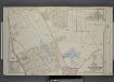
Part of Ward 4. [Map bound by Fox Hill Golf Links, Oak St, Virginia Ave, Clifton Ave, Pennsylvania Ave, Maryland Ave, Fingerboard Road, Clove Ave, Richmond Road, Vanderbilt Ave; Map bound by DeKalb, Danube Ave, Clove Ave, Richmond Road]
from Atlas of the borough of Richmond, city of New York.
Part of Clifton.
from Atlas of Staten Island, Richmond County, New York, from official records and surveys; compiled and drawn by F. W. Beers.
Part of Ward 4. [Map bound by Mosel Ave, Staten Island Rail Road, Rockwell Ave, Pennsylvania Ave, Clifton Ave, Tompkins Ave, Fingerboard Road, Grant Ave, Sherman Ave, Clover Ave]
from Atlas of the city of New York, borough of Richmond, Staten Island. From actual surveys and original plans, by George W. and Walter S. Bromley.
Part of Ward 4. [Map bound by Richmond Road, Vanderbilt Ave, Tompkins Ave (Centre St), Clifton Ave, Fletcher St, Wall St, Staten Island Rail Road, Pond, Targee St (Simonson PL)]
from Atlas of the city of New York, borough of Richmond, Staten Island. From actual surveys and original plans, by George W. and Walter S. Bromley.
Part of Ward 4. [Map bound by Steuben St, Mosel Ave, Clove Ave, Richmond Road]
from Atlas of the city of New York, borough of Richmond, Staten Island. From actual surveys and original plans, by George W. and Walter S. Bromley.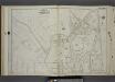
Part of Ward 4. [Map bound by Fingerboard Road, Sherman Ave, Grant Ave, Tompkins Ave, Richmond Ave, Sand Lane]
from Atlas of the city of New York, borough of Richmond, Staten Island. From actual surveys and original plans, by George W. and Walter S. Bromley.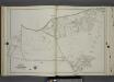
Part of Ward 4. [Map bound by Richmond Road, Baltic Ave, Hanover Ave (Main), Neckar Ave, Weser Ave, Elbe Ave, Mosel Ave, Clove Ave, Fingerboard Road, Staten Island Rail Road, Cornelia St, Wilson St, Old Town Road]
from Atlas of the city of New York, borough of Richmond, Staten Island. From actual surveys and original plans, by George W. and Walter S. Bromley.
Borough of Richmond, Topographical Survey.
from Borough of Richmond, Topographical Survey.
Staten Island, V. 1, Plate No. 39 [Map bounded by Virginia Ave., Hope Ave., Lincoln Pl.]
From Atlas 162. Vol. 1, 1917.
Staten Island, V. 1, Plate No. 40 [Map bounded by Hope Ave., Tompkins Ave., State Ave.]
From Atlas 162. Vol. 1, 1917.
Staten Island, V. 1, Plate No. 38 [Map bounded by Chestnut Ave., Upper New York Bay, Bayview Ave., St. Johns Ave.]
From Atlas 162. Vol. 1, 1917.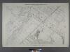
Sheet No. 48. [Includes Dongan Hills, Southside Boulevard, Four Corners road, Liberty Avenue and Cromwell Avenue.]; Borough of Richmond, Topographical Survey.
from Borough of Richmond, Topographical Survey. Staten Island. Topographical Bureau.,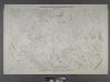
Sheet No. 40. [Includes Dongan Hills, Fingerboard Road, Richmond Road, Duncan Street, Oakdale Avenue, (Emerson Hill, Old Town)Linden Park.]; Borough of Richmond, Topographical Survey.
from Borough of Richmond, Topographical Survey. Staten Island. Topographical Bureau.,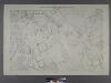
Sheet No. 41. [Includes Fingerboard Road, Old Town Road in Grasmere, Chicago Avenue, Sand Lane, Pickersgill Avenue & Cleveland Place in Arrochar.]; Borough of Richmond, Topographical Survey.
from Borough of Richmond, Topographical Survey. Staten Island. Topographical Bureau.,
Part of Ward 4. [Map bound by Chestnut Ave, Bay St (New York Ave), Sylvaton Ter., Edgewater St (Bay St), Bulkhead Line, Maryland Ave, Tompkins Ave, Pennsylvania Ave]
from Atlas of the city of New York, borough of Richmond, Staten Island. From actual surveys and original plans, by George W. and Walter S. Bromley.
Staten Island, V. 1, Plate No. 29 [Map bounded by Serpentine Rd., Howard Ave., Cedar Ter.]
From Atlas 162. Vol. 1, 1917.
Staten Island, V. 1, Plate No. 44 [Map bounded by State Ave., Tompkins Ave., Richmond Ave., Crescent Ave., Prospect Ave.]
From Atlas 162. Vol. 1, 1917.
Staten Island, V. 1, Plate No. 41 [Map bounded by St. Johns Ave., Bay, Wadsworth Ave., Tompkins Ave.]
From Atlas 162. Vol. 1, 1917.
Richmond, Plate No. 78 [Map bounded by Chestnut Ave., Clifton Ave.]
From Atlas 160, 1898.
Richmond, Plate No. 81 [Map bounded by Clifton Ave., New York Ave., St. Johns Ave., 4th St.]
From Atlas 160, 1898.
Map of Staten Island, Richmond County, New York City, from surveys under the direction of H. F. Walling.
From Staten Island
21D - N.Y. City (Aerial Set).
from Sectional aerial maps of the City of New York / [photographed and assembled under the direction of the chief engineer, July 1st, 1924].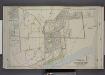
Part of Ward 4. [Map bound by Fingerboard Road, Tompkins Ave, Lyman Ave, New York Ave, Richmond Ave, Sea Ave, Seaside Boulevard, Old Town Road]
from Atlas of the borough of Richmond, city of New York.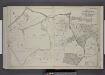
Part of Wards 2 & 4. [Map bound by Richmond Turnpike, Clove Oak St, Richmond Road, Clove Ave, The Staten Island Railway Co., Old Town Road, Ocean Terrace, Todt Hill Road, Chestnut Ave]
from Atlas of the borough of Richmond, city of New York.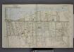
Part of Ward 4. [Map bound by Pier Line, New York Ave, Lyman Ave, Fingerboard Road, Fletcher St, Oak St, Fox Hill Golf Links, Vanderbilt Ave]
from Atlas of the borough of Richmond, city of New York.
Section 9
from Atlas of Staten Island, Richmond County, New York, from official records and surveys; compiled and drawn by F. W. Beers.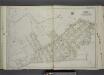
Part of Ward 2. [Map bound by Serpentine Road, Howard Ave (Serpentine RD) , Broad St, Gordon St, Tompkins St (Serpentine RD), Warren St, Pleasant PL, Vanderbilt Ave, Richmond Road, Northcole Ave, Cedar Terrace]
from Atlas of the city of New York, borough of Richmond, Staten Island. From actual surveys and original plans, by George W. and Walter S. Bromley.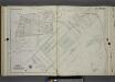
Part of Ward 4. [Map bound by Staten Island Rail Road, Fingerboard Road, Old Town Road, Scott Ave, Rambler Road, Benton Ave]
from Atlas of the city of New York, borough of Richmond, Staten Island. From actual surveys and original plans, by George W. and Walter S. Bromley.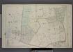
Part of Wards 1 & 2. [Map bound by Grymes Hill, Howard Ave, Woodside Ave, Centre Ave, Irving PL, Vanderbilt Ave, Richmond Road, Clove Road, Clove PL, Lakewood RD, Richmond Turnpike]
from Atlas of the borough of Richmond, city of New York.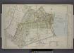
![Part of Ward 4. [Map bound by Fox Hill Golf Links, Oak St, Virginia Ave, Clifton Ave, Pennsylvania Ave, Maryland Ave, Fingerboard Road, Clove Ave, Richmond Road, Vanderbilt Ave; Map bound by DeKalb, Danube Ave, Clove Ave, Richmond Road]](https://images-2.georeferencer.com/images/iiif/186391613484/full/,300/0/native.jpg)

