Maps of Richmond County
Borough of Richmond, Topographical Survey.
from Borough of Richmond, Topographical Survey.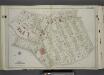
Part of Ward 1. [Map bound by Brighton Ave, York Ave, Pauw St (Centre St), Jersey St, Taft Ave (6th Ave), Westervelt Ave (Oak St), Richmond Turnpike, Cebra Ave, Castleton Ave, Wester Ave]
from Atlas of the city of New York, borough of Richmond, Staten Island. From actual surveys and original plans, by George W. and Walter S. Bromley.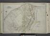
Part of Ward 2. [Map bound by Richmond Turnpike, Arriette St, Bulkhead Line, Bay St (Griffin St), Congress St, Van Duzer St (Richmond RD), Sands St, Wave St, Beach St, St. Pauls Ave, Occident Ave, Ward Ave, Austin PL (St)]
from Atlas of the city of New York, borough of Richmond, Staten Island. From actual surveys and original plans, by George W. and Walter S. Bromley.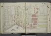
Part of Ward 1. [Map bound by Fort PL, St. Marks PL (Tompkins Ave), Hyatt St, Borough PL (South St), Bulkhead Line, Arrietta St, Richmond Turnpike, Westervelt Ave (Oak St), Hendricks Ave (5th Ave), Sherman Ave]
from Atlas of the city of New York, borough of Richmond, Staten Island. From actual surveys and original plans, by George W. and Walter S. Bromley.
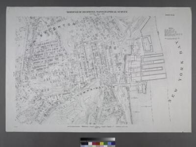
Staten Island, V. 1, Plate No. 11 (1917) [Map bounded by Crescent Ave., Sherman Ave., Brook, Jersey]
From Atlas 162. Vol. 1, 1917.
Staten Island, Plate No. 7 [Map bounded by Richmond Turn Pike, Arietta, New York bay, Swan, St. Paul's Ave.]
From Atlas 159, 1885.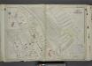
Part of Ward 1. [Map bound by Richmond Terrace (Bay St), Pierhead Line, Hyatt St, St. Marks PL (Tompkins Ave), Fort PL, Daniel Low Terrace, Hamilton Ave, Nicholas St]
from Atlas of the city of New York, borough of Richmond, Staten Island. From actual surveys and original plans, by George W. and Walter S. Bromley.
Staten Island, V. 1, Plate No. 10 [Map bounded by Hannah, Bay, Grant, St. Paul's Ave.]
From Atlas 162. Vol. 1, 1917.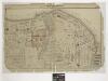
Part of New Brighton : Town of Castleton.
From Atlas of Staten Island, Richmond County, New York, from official records and surveys; compiled and drawn by F. W. Beers.
Part of New Brighton : Town of Castleton.
from Atlas of Staten Island, Richmond County, New York, from official records and surveys; compiled and drawn by F. W. Beers.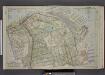
Part of Ward 1. [Map bound by Kill Van Kull, Pier Head of 1889 & 1904, Arrietta St, First Ave, Westervelt Ave, Second Ave, York Ave, Eleventh St, Prospect Ave, Franklin Ave]
from Atlas of the borough of Richmond, city of New York.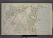
Part of Wards 1 & 2. [Map bound by Brighton Ave, York Ave, Second Ave, Westervelt Ave, Arrietta St, Pier Line, Front St, Cross St, Union St, Beach St, Richmond Road, Stone St, Trossach Road, Howard Ave, Richmond Turnpike, Woodstock Ave, Glen Ave]
from Atlas of the borough of Richmond, city of New York.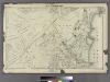
Section 8.
from Atlas of Staten Island, Richmond County, New York, from official records and surveys; compiled and drawn by F. W. Beers.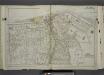
Part of Ward 1. [Map bound by Pierhead Line, Richmond Terrace, Nicholas St, St. Marks PL, Hamilton Ave, Daniel Low Terrace, Fort PL, Taft Ave (6th Ave), Jersey St, Pauw St (Center), York Ave, Prospect Ave, La Fayette Ave]
from Atlas of the city of New York, borough of Richmond, Staten Island. From actual surveys and original plans, by George W. and Walter S. Bromley.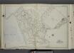
Part of Ward 1. [Map bound by Greenwood Ave, Ridgewood PL, Castleton Ave, Brighton Ave, Third St, La Fayette Ave, Prospect Ave, York Ave, Webster Ave, Cebra Ave, Richmond Turnpike, Silver Lake Reservoir]
from Atlas of the city of New York, borough of Richmond, Staten Island. From actual surveys and original plans, by George W. and Walter S. Bromley.
Borough of Richmond, Topographical Survey.
from Borough of Richmond, Topographical Survey.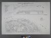
Borough of Richmond, Topographical Survey.
from Borough of Richmond, Topographical Survey.
Richmond, Plate No. 48 [Map bounded by St. Marks Pl., Richmond Terrace East, Jay St., Fort St., Westervelt Ave.]
From Atlas 160, 1898.
Staten Island, Plate No. 9 [Map bounded by Clinton, Bay, Jackson]
From Atlas 159, 1885.
Staten Island, Plate No. 2 [Map bounded by Bank, westervelt Ave., York Ave.]
From Atlas 159, 1885.
Staten Island, V. 1, Plate No. 1 [Map bounded by Kill van Kull, Westervelt Ave., York Ave.]
From Atlas 162. Vol. 1, 1917.
21B - N.Y. City (Aerial Set).
from Sectional aerial maps of the City of New York / [photographed and assembled under the direction of the chief engineer, July 1st, 1924].
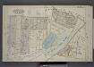
Map of Staten Island, Richmond County, New York City, from surveys under the direction of H. F. Walling.
From Staten Island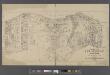
Map of New Brighton, Staten Island [cartographic material] : 1st, 2nd and 3rd wards.
From Staten Island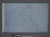
Height District Map Section No. 21; Height district map / City of New York, Board of Estimate and Apportionment.
from Height district map / City of New York, Board of Estimate and Apportionment. New York (N.Y.). Board of Estimate and Apportionment,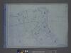
Area District Map Section No. 21; Area district map / City of New York, Board of Estimate and Apportionment.
from Area district map / City of New York, Board of Estimate and Apportionment. New York (N.Y.). Board of Estimate and Apportionment,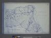
Use District Map Section No. 21; Use district map / City of New York, Board of Estimate and Apportionment.
from Use district map / City of New York, Board of Estimate and Apportionment. New York (N.Y.). Board of Estimate and Apportionment,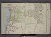
Part of Ward 1. [Map bound by Franklin Ave, Prospect Ave, "The Cedars", La Fayette Ave, Webster Ave, Castleton Ave, Brighton Ave, Forest Ave, Sailors Snug Harbor, Kill Van Kull]
from Atlas of the borough of Richmond, city of New York.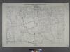
Sheet No. 10. [Includes Sailor's Snug Harbor (Livingston), Henderson Avenue, Castleton Avenue, Prospect Avenue, N.St.Austins Avenue, S. St. Austins Avenue, Brighton Avenue and Webster Avenue.]
from Borough of Richmond, Topographical Survey.