Maps of Richmond County
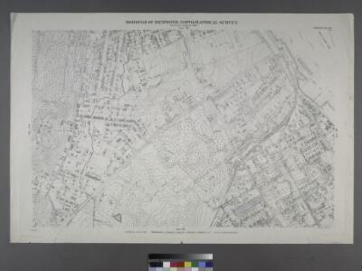
Borough of Richmond, Topographical Survey.
from Borough of Richmond, Topographical Survey.
Part of Ward 4. [Map bound by Richmond Road, Vanderbilt Ave, Tompkins Ave (Centre St), Clifton Ave, Fletcher St, Wall St, Staten Island Rail Road, Pond, Targee St (Simonson PL)]
from Atlas of the city of New York, borough of Richmond, Staten Island. From actual surveys and original plans, by George W. and Walter S. Bromley.
Staten Island, V. 1, Plate No. 38 [Map bounded by Chestnut Ave., Upper New York Bay, Bayview Ave., St. Johns Ave.]
From Atlas 162. Vol. 1, 1917.
Part of Ward 4. [Map bound by Vanderbilt Ave, Pierhead Line, North St, Front St, Maple Ave, Edgewater St (Bay St), Bay St (New York Ave), Chestnut Ave, Tompkins Ave (Centre St)]
from Atlas of the city of New York, borough of Richmond, Staten Island. From actual surveys and original plans, by George W. and Walter S. Bromley.
Staten Island, V. 1, Plate No. 32 [Map bounded by Harrison, Brownel, Upper New York Bay, Simonson Ave., Tompkins Ave.]
From Atlas 162. Vol. 1, 1917.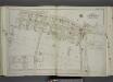
Part of Ward 2. [Map bound by Broad St, Bay St, Thompson St, Front St, Dock St, Vanderbilt Ave, Pleasant PL, Coursen PL, Dix PL (Elm), Hill St, Fulton St, Meadow St, Patten St]
from Atlas of the city of New York, borough of Richmond, Staten Island. From actual surveys and original plans, by George W. and Walter S. Bromley.
Sheet No. 33. [Includes Concord, Grasmere, Fort Wadsworth and Rose Bank.]; Borough of Richmond, Topographical Survey.
from Borough of Richmond, Topographical Survey. Staten Island. Topographical Bureau.,
Staten Island, Plate No. 17 [Map bounded by New York Bay, Willow Ave., Simonson]
From Atlas 159, 1885.
Richmond, Plate No. 78 [Map bounded by Chestnut Ave., Clifton Ave.]
From Atlas 160, 1898.
Staten Island, Plate No. 13 [Map bounded by Targee, Elm, Varian, Cedar, Mc Keon]
From Atlas 159, 1885.
Staten Island, Plate No. 15 [Map bounded by Brooks, Thompson, Harrison]
From Atlas 159, 1885.
Section 9
from Atlas of Staten Island, Richmond County, New York, from official records and surveys; compiled and drawn by F. W. Beers.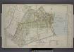
Part of Ward 2. [Map bound by Eddy St, Howard Ave, Trossach Road, St. Pauls Ave, Richmond Road, Beach St, Union PL, Cross St, Bulkhead Line, Vanderbilt Ave, Irving PL, Woodside Ave]
from Atlas of the borough of Richmond, city of New York.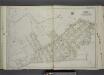
Part of Ward 2. [Map bound by Serpentine Road, Howard Ave (Serpentine RD) , Broad St, Gordon St, Tompkins St (Serpentine RD), Warren St, Pleasant PL, Vanderbilt Ave, Richmond Road, Northcole Ave, Cedar Terrace]
from Atlas of the city of New York, borough of Richmond, Staten Island. From actual surveys and original plans, by George W. and Walter S. Bromley.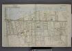
Part of Ward 4. [Map bound by Pier Line, New York Ave, Lyman Ave, Fingerboard Road, Fletcher St, Oak St, Fox Hill Golf Links, Vanderbilt Ave]
from Atlas of the borough of Richmond, city of New York.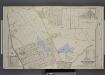
Part of Ward 4. [Map bound by Fox Hill Golf Links, Oak St, Virginia Ave, Clifton Ave, Pennsylvania Ave, Maryland Ave, Fingerboard Road, Clove Ave, Richmond Road, Vanderbilt Ave; Map bound by DeKalb, Danube Ave, Clove Ave, Richmond Road]
from Atlas of the borough of Richmond, city of New York.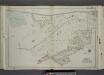
Part of Ward 2. [Map bound by Richmond Turnpike, Austin PL, Occident Ave, St. Pauls Ave, Stone St, Targee St, Purroy St (Elm St), Gordon St, Broad St, Howard Ave (Serpentine RD), Eddy St, Duncan Ave, Thressea PL]
from Atlas of the city of New York, borough of Richmond, Staten Island. From actual surveys and original plans, by George W. and Walter S. Bromley.
Sheet No. 32. [Includes Grymes Hill, (Emerson Hill) and Concord.]; Borough of Richmond, Topographical Survey.
from Borough of Richmond, Topographical Survey. Staten Island. Topographical Bureau.,
Borough of Richmond, Topographical Survey.
from Borough of Richmond, Topographical Survey.
Part of Ward 4. [Map bound by Chestnut Ave, Bay St (New York Ave), Sylvaton Ter., Edgewater St (Bay St), Bulkhead Line, Maryland Ave, Tompkins Ave, Pennsylvania Ave]
from Atlas of the city of New York, borough of Richmond, Staten Island. From actual surveys and original plans, by George W. and Walter S. Bromley.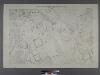
Sheet No. 41. [Includes Fingerboard Road, Old Town Road in Grasmere, Chicago Avenue, Sand Lane, Pickersgill Avenue & Cleveland Place in Arrochar.]; Borough of Richmond, Topographical Survey.
from Borough of Richmond, Topographical Survey. Staten Island. Topographical Bureau.,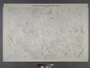
Sheet No. 40. [Includes Dongan Hills, Fingerboard Road, Richmond Road, Duncan Street, Oakdale Avenue, (Emerson Hill, Old Town)Linden Park.]; Borough of Richmond, Topographical Survey.
from Borough of Richmond, Topographical Survey. Staten Island. Topographical Bureau.,
Staten Island, V. 1, Plate No. 39 [Map bounded by Virginia Ave., Hope Ave., Lincoln Pl.]
From Atlas 162. Vol. 1, 1917.
Staten Island, V. 1, Plate No. 29 [Map bounded by Serpentine Rd., Howard Ave., Cedar Ter.]
From Atlas 162. Vol. 1, 1917.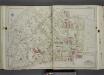
Part of Ward 2. [Map bound by St. Pauls Ave, Beach St, Jackson St, Van Duzer St (Richmond RD), Sands St, Wave St, Front St, Thompson St, Bay St, Broad St, Gordon St, Purroy St (Elm), Targee St]
from Atlas of the city of New York, borough of Richmond, Staten Island. From actual surveys and original plans, by George W. and Walter S. Bromley.
Richmond, Plate No. 81 [Map bounded by Clifton Ave., New York Ave., St. Johns Ave., 4th St.]
From Atlas 160, 1898.
Staten Island, Plate No. 12 [Map bounded by Boyd, Brooks, Mc Keon, Varian Cedar]
From Atlas 159, 1885.
Staten Island, V. 1, Plate No. 22 [Map bounded by Broad, Brownell, Harrison, Quinn, Upper New York Bay, Thompson]
From Atlas 162. Vol. 1, 1917.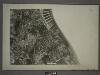
21D - N.Y. City (Aerial Set).
from Sectional aerial maps of the City of New York / [photographed and assembled under the direction of the chief engineer, July 1st, 1924].