Maps of New York

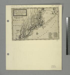
New England, New York, New Jersey, and Pensilvania &c. / by H. Moll, geographer.
from Parts
Nordost-Staaten der Union.
1 : 5000000 Andree, Richard
NOVA | BELGICA | ET | ANGLIA | NOVA.
[Amsterdam : Joan Blaeu]
Map no. I : [to accompany A bill in the chancery of New Jersey, at the suit of John, Earl of Stair ... against Benjamin Bond].
from A bill in the chancery of New-Jersey, at the suit of John earl of Stair, and others, proprietors of the eastern-division of New-Jersey; against Benjamin Bond. and some other persons of Elizabeth-Town, distinguished by the name of the Clinker lot right men. With three large maps, done from copper-plates. To which is added; the publications of the Council of proprietors of East New-Jersey, and Mr. Nevill's speeches to the General assembly, concerning the riots committed in New-Jersey, and the pretences of the rioters, and their seducers. These papers will give a better light into the history and constitution of New-Jersey, than any thing hitherto published, the matters whereof have been chiefly collected from records. Published by subscription:
Recens edita totius Novi Belgii, in America Septentrionali siti

Railroad Map Of The Eastern & Middle States.
1 : 380160 Rand McNally and Company
Novi Belgii Novaeque Angliae nec non partis Virginiae tabula / multis in locis emendata a Nicolao Joannis Visschero
1 : 2500000 Annotatie: Lit.: The map collectors' circle, no. 24 (1965); Oorspr. uitg.: [Amsterdam : N.J. Visscher, ca. 1655] Visscher, Claes Jansz. [Amsterdam : nunc apud Petr. Schenk Iun.]
A new chart of America with the harbors of New York, Boston, &c / drawn from the latest authorities by W. Heather, 1799 ; Stephenson sculp.
from Charts and maps
Recens edita totius Novi Belgii in America Septentrionali siti
1 : 2250000 Seutter, Matthaeus, 1678-1756 Matthaei Seutteri
Belgii novi, angliae novae, et partis Virginiae : novissima delineatio
1 : 2450000 Jansson, Jan, 1588-1664 Prostant ... apud Petrum Schenk, et Gerardum Valk
197-198. United States of America, North East. The World Atlas.
1 : 2500000 USSR (Union of Soviet Socialist Republics).
A chart of the sea coasts of New-England, New-Jarsey, Virginia, Maryland and Carolina : from C. Cod to C. Hatteras / by John Seller, hydrogr. to the King ; Iames Clerk sculpsit.
from Atlas terrestris, or, A book of mapps of all the empires, monarchies, kingdomes, regions, dominions, principalities, and countreys in the whole world : accomodated with a brief description of the nature and quality of each particular countrey / by Iohn Seller, hydrographer to the Kings most excellent majestie.
Totius Neobelgii nova et accuratissima tabula / [Hugo Allardt]
1 : 2500000 Annotatie: Lit.: The map collectors' circle, no. 24 (1965); Oorspr. uitg.: [Amsterdam] : Hugo Allardt, [ca. 1656] Allardt, Hugo [Amsterdam : Hugo Allardt excut.]
Novi Belgii Novaeque Angliae nec non partis Virginiae tabula / multis in locis emendata per Nicolaum Visscher.
from John H. Levine Collection
[Côte de York-town à Boston : Marches de l'armée].
from Histoire des troubles de l'Amérique anglaise, ecrite sur les mémoires les plus authentiques ... par François Soulés ...

[Map of Virginia, North Carolina, and South Carolina].
from Aussführlich, und umständlicher Bericht von der berühmten Landschafft Carolina : in dem engelländischen America gelegen / an Tag gegeben von Kocherthalern.
New York.
from Whole
Novi Belgii Novaeqve Angliae nec non partis Virginiae Tabula

A map of the provinces of New-York and New Jersey : with a part of Pennsylvania and the Province of Quebec / from the topographical observations of C. J. Sauthier ; engraved and published by Matthew Albert Lotter.
from Parts

Map Montreal and Boston Air Line.
1 : 2223700 Montreal and Boston Air Line
A map of the provinces of New-York and New Jersey : with a part of Pennsylvania and the Province of Quebec / from the topographical observations of C. J. Sauthier ; engraved and published by Matthew Albert Lotter.
from Charts and maps
Recens edita totius Novi Belgii in America Septentrionali siti / delineatio cura et sumtibus Tob. Conr. Lotteri, Sac. Caes. Maj. Geographi August. Vind.
from John H. Levine Collection Conrad Lotter,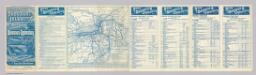
Rome, Watertown & Ogdensburg Railroad.
1 : 4308480 Rome, Watertown & Ogdensburg Railroad Company
A new map of the most considerable plantations of the English in America / Sutton Nicholls, sculp.; A new sett of maps both of antient and present geography: wherein not only the latitude and longitude of many places are corrected according to the latest observations, but also the most remarkable differences of antient and present geography may be quickly discern'd by a bare inspection or comparing of correspondent maps, which seems to be the most natural and easy method to lead young students (for whose use the work is principally intended) unto a competent knowledge of the geographical science: together with a geographical treatise particularly adapted to the use and design of these maps / by Edward Wells, M.A. and student of Christ-Church, Oxon.
from A new sett of maps both of antient and present geography : wherein not only the latitude and longitude of many places are corrected according to the latest observations, but also the most remarkable differences of antient and present geography may be quickly discern'd by a bare inspection or comparing of correspondent maps, which seems to be the most natural and easy method to lead young students (for whose use the work is principally intended) unto a competent knowledge of the geographical science : together with a geographical treatise particularly adapted to the use and design of these maps / by Edward Wells, M.A. and student of Christ-Church, Oxon. Wells, Edward; Sheldonian Theatre,
Mappa geographica provinciae novae eboraci ab anglis New-York
1 : 10000 New Jersey Sauthier, Claudii Josephi Homannianor Heredum
A new map of New England, New York, New Iarsey, Pensilvania, Maryland, and Virginia / by Philip Lea in Cheap-side, London.
from Parts
Map of the interior travels through America, delineating the march of the army