Maps of Piedmont

[Map of Virginia, North Carolina, and South Carolina].
from Aussführlich, und umständlicher Bericht von der berühmten Landschafft Carolina : in dem engelländischen America gelegen / an Tag gegeben von Kocherthalern.
A map of those parts of Virginia, North Carolina, South Carolina & Georgia which were the scenes of the most important operations of the southern armies
from Parts
Les États Unis de l'Amérique septentrionale
1 : 6050000 Spojené státy americké-oblast východní Bonne, Rigobert André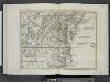
Il Maryland, il Jersey Meridionale, la Delaware e la parte orientale della Virginia, e Carolina Settentrionale.
from Le colonie unite dell' America settentrle : di nuova projezione a s.s.e.e. li Signori Riformatori dello Studio di Padova.
Nordost-Staaten der Union.
1 : 5000000 Andree, Richard
The marches of Lord Cornwallis in the Southern Provinces : now States of North America, comprehending the two Carolinas, with Virginia and Maryland, and the Delaware counties / by William Faden, geographer to the King.
from Charts and maps
Sheet 4: United States of Nth. America.
1 : 1584000 Tardieu, P.F.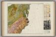
Soil Map of the United States, Section 8. Atlas of American Agriculture.
1 : 2500000 Marbut, Curtis F.
D'Engelze volkplanting in Virginie / door Iohan Smith bezogt en verder uytgeset = Peuplade des Anglois dans la Virginie / visitée et augmentée par Jean Smith, suivant qu il l'a décrite lui-même dans son voyage ; rectifiée sur de nouvelles observations fa
from Virginia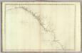
The coast of the United States from New York to St. Augustine (4th sheet)
1 : 900000 Blunt, Edmund M. (Edmund March), 1770-1862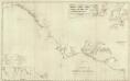
Composite: U.S. coast N.Y. to St. Augustine.
1 : 900000 Blunt, Edmund M. (Edmund March), 1770-1862
Virginia, Maryland, and Delaware / J. Knight sc.
from View of the United States, historical, geographical, and statistical, exhibiting, in a convenient form, the natural and artificial features of the several states, and embracing those leading branches of history and statistics best adapted to develop the present condition of the North American union ... By William Darby.
A new chart of the coast of North America : from New York to Cape Hatteras, including the bays of Delaware and Chesapeak, with the coasts of New Jersey, Maryland, Virginia and part of the coast of North Carolina / by Captain N. Holland.
from Parts
A chart of the coast of New York, New Jersey, Pensilvania, Maryland, Virginia, North Carolina, & c.
from Charts and maps
Carte des Etats-unis : provinces méridionales.
from Parts

Virginia / S. Lewis, del.
from Virginia
New England, New York, New Jersey, and Pensilvania &c. / by H. Moll, geographer.
from Parts
The state of Virginia : from the best authorities / by Samuel Lewis, 1809 ; Smither, sculpt.
from Carey's American atlas.
Virginiae Item et Floridae Americae Provinciarum, nova Descriptio. [Karte], in: Gerardi Mercatoris Atlas, sive, Cosmographicae meditationes de fabrica mundi et fabricati figura, S. 553.
1 Karte aus Atlas Mercator, Gerhard Montanus, Petrus
Nouvelle carte de la Caroline / par R. Morden.; L'Amerique angloise, ou Description des isles et terres du roi d'Angleterre, dans l'Amérique. Avec de nouvelles cartes de chaque isle & terres. Traduit de l'anglois.
from L'Amerique angloise, ou Description des isles et terres du roi d'Angleterre, dans l'Amérique. Avec de nouvelles cartes de chaque isle & terres. Traduit de l'anglois. Blome, Richard,
Maryland, Virginia, North Carolina, and South Carolina.
1 : 3651000 Fisher, Richard Swainson
Shell Sectional Map No. 3 - Middle Atlantic States.
1 : 1457280 Shell Oil Company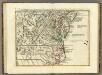
Il Maryland, il Jersey Meridionale, la Delaware.
1 : 2100000 Zatta, Antonio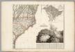
Sheet 4: United States of Nth. America.
1 : 1584000 Tardieu, P.F.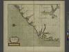
A new mapp of CAROLINA
from The sea-atlas : containing an hydrographical description of most of the sea-coasts of the known parts of the world.
Virginiae partis australis, et Floridae partis orientalis, interiacentiumque regionum Nova Descriptio. [Karte], in: Le théâtre du monde, ou, Nouvel atlas contenant les chartes et descriptions de tous les païs de la terre, Bd. 2, S. 321.
1 Karte aus Atlas Blaeu, Willem Janszoon und Blaeu, Joan Blaeu, Willem Janszoon
A new map of Virginia from the best authorities / by T. Kitchin, Geogr.
from London magazine, or, Gentleman's monthly intelligencer (1747)

![[Map of Virginia, North Carolina, and South Carolina].](https://images-2.georeferencer.com/images/iiif/716202539102/full/,300/0/native.jpg)

