Maps of New York


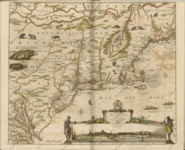
Novi Belgii Novaeque Angliae nec non partis Virginiae tabula / multis in locis emendata a Nicolao Joannis Visschero
1 : 2500000 Annotatie: Lit.: The map collectors' circle, no. 24 (1965); Oorspr. uitg.: [Amsterdam : N.J. Visscher, ca. 1655] Visscher, Claes Jansz. [Amsterdam : nunc apud Petr. Schenk Iun.]
Novi Belgii Novaeque Angliae nec non partis Virginiae tabula : multis in locis emendata
1 : 2250000 Visscher, Nicolaes, 1649-1702 Ex officina N. Visscher
Totius Neobelgii nova et accuratissima tabula / [Hugo Allardt]
1 : 2500000 Annotatie: Lit.: The map collectors' circle, no. 24 (1965); Oorspr. uitg.: [Amsterdam] : Hugo Allardt, [ca. 1656] Allardt, Hugo [Amsterdam : Hugo Allardt excut.]
Belgii novi, angliae novae, et partis Virginiae : novissima delineatio
1 : 2450000 Jansson, Jan, 1588-1664 Ioannes Ianssonius
A new chart of America with the harbors of New York, Boston, &c / drawn from the latest authorities by W. Heather, 1799 ; Stephenson sculp.
from Charts and maps
Recens edita totius Novi Belgii in America Septentrionali siti
1 : 2250000 Seutter, Matthaeus, 1678-1756 Matthaei Seutteri
Novi Belgii Novaeque Angliae nec non partis Virginiae tabula / multis in locis emendata per Nicolaum Visscher.
from John H. Levine Collection
197-198. United States of America, North East. The World Atlas.
1 : 2500000 USSR (Union of Soviet Socialist Republics).


Novi Belgii Novaeque Angliae nec non partis Virginiae tabula multis in locis emendata
1 : 2000000 a Nicolao Joannis Visschero [S.l.] : [s.n.]
Recens edita totius Novi Belgii, in America Septentrionali siti
United States of America, northern part.
1 : 2100000 Pinkerton, John, 1758-1826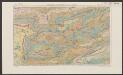
Nova Belgica Et Anglia Nova [Karte], in: Le théâtre du monde, ou, Nouvel atlas contenant les chartes et descriptions de tous les païs de la terre, Bd. 2, S. 303.
1 Karte aus Atlas Blaeu, Willem Janszoon und Blaeu, Joan Blaeu, Willem Janszoon
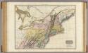
Railroad Map Of The Eastern & Middle States.
1 : 380160 Rand McNally and Company
Lloyd's Railroad, Telegraph & Express Map of the Eastern States
Lloyd's Railroad, Telegraph & Express Map of the Eastern States to accompany Lloyd's Railroad, Telegraph & Express Map of the United States and Canadas. This map shows the communication lines of the eastern states of the Union as they existed in 1863. Reliable communication networks were vital during the war to send troops and messages from one theatre of conflict to another. The map also lists the position of telegraph stations close to the offices of Express companies which provided the main form of travel in this period of American history.
Northern provinces of the United States

New York.
from Whole
Nova Belgica Et Anglia Nova [Karte], in: Novus Atlas, das ist, Weltbeschreibung, Bd. 2, S. 306.
1 Karte aus Atlas Blaeu, Joan Blaeu, Willem Janszoon
Mappa geographica provinciae novae eboraci ab anglis New-York
1 : 10000 New Jersey Sauthier, Claudii Josephi Homannianor Heredum
A new map of New England, New York, New Iarsey, Pensilvania, Maryland, and Virginia / by Philip Lea in Cheap-side, London.
from Parts
Map no. I : [to accompany A bill in the chancery of New Jersey, at the suit of John, Earl of Stair ... against Benjamin Bond].
from A bill in the chancery of New-Jersey, at the suit of John earl of Stair, and others, proprietors of the eastern-division of New-Jersey; against Benjamin Bond. and some other persons of Elizabeth-Town, distinguished by the name of the Clinker lot right men. With three large maps, done from copper-plates. To which is added; the publications of the Council of proprietors of East New-Jersey, and Mr. Nevill's speeches to the General assembly, concerning the riots committed in New-Jersey, and the pretences of the rioters, and their seducers. These papers will give a better light into the history and constitution of New-Jersey, than any thing hitherto published, the matters whereof have been chiefly collected from records. Published by subscription:
Map of the interior travels through America, delineating the march of the army

A map of the provinces of New-York and New Jersey : with a part of Pennsylvania and the Province of Quebec / from the topographical observations of C. J. Sauthier ; engraved and published by Matthew Albert Lotter.
from Parts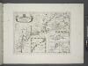
A new map of the most considerable plantations of the English in America / Sutton Nicholls, sculp.; A new sett of maps both of antient and present geography: wherein not only the latitude and longitude of many places are corrected according to the latest observations, but also the most remarkable differences of antient and present geography may be quickly discern'd by a bare inspection or comparing of correspondent maps, which seems to be the most natural and easy method to lead young students (for whose use the work is principally intended) unto a competent knowledge of the geographical science: together with a geographical treatise particularly adapted to the use and design of these maps / by Edward Wells, M.A. and student of Christ-Church, Oxon.
from A new sett of maps both of antient and present geography : wherein not only the latitude and longitude of many places are corrected according to the latest observations, but also the most remarkable differences of antient and present geography may be quickly discern'd by a bare inspection or comparing of correspondent maps, which seems to be the most natural and easy method to lead young students (for whose use the work is principally intended) unto a competent knowledge of the geographical science : together with a geographical treatise particularly adapted to the use and design of these maps / by Edward Wells, M.A. and student of Christ-Church, Oxon. Wells, Edward; Sheldonian Theatre,
Novi Belgii Novaeqve Angliae nec non partis Virginiae Tabula

Recens edita totius Novi Belgii in America Septentrionali siti / delineatio cura et sumtibus Tob. Conr. Lotteri, Sac. Caes. Maj. Geographi August. Vind.
from John H. Levine Collection Conrad Lotter,
United States.
1 : 3380000 Sharpe, J.