Maps of New York

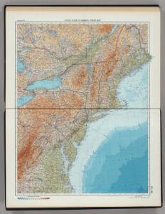
197-198. United States of America, North East. The World Atlas.
1 : 2500000 USSR (Union of Soviet Socialist Republics).
Belgii novi, angliae novae, et partis Virginiae : novissima delineatio
1 : 2450000 Jansson, Jan, 1588-1664 Prostant ... apud Petrum Schenk, et Gerardum Valk

Totius Neobelgii nova et accuratissima tabula / [Hugo Allardt]
1 : 2500000 Annotatie: Lit.: The map collectors' circle, no. 24 (1965); Oorspr. uitg.: [Amsterdam] : Hugo Allardt, [ca. 1656] Allardt, Hugo [Amsterdam : Hugo Allardt excut.]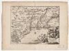
Novi Belgii, quod nunc Novi Jorck vocatur, Novae q[ue] Angliae & partis Virginiae : accuratissima et novissima delineatio
1 : 3500000 Montanus, Arnoldus, 1625?-1683 J. Meurs
Recens edita totius Novi Belgii in America Septentrionali siti
1 : 2250000 Seutter, Matthaeus, 1678-1756 Matthaei Seutteri
NOVA | BELGICA | ET | ANGLIA | NOVA.
[Amsterdam : Joan Blaeu]
Nova tabula geographica complectens Borealiorem Americae partem, in qua exacte delineatae sunt Canada sive Nova Francia, Nova Scotia, Nova Anglia, Novum Belgium, Pensylvania, Virginia, Carolina, et Terra Nova, cum omnibus littorum pulvinorumque profunditatibus
1 : 4000000 â Nicolao Visscher Luggardus van Anse schulp. Amstlodami : nunc apud Petrus Schenk Junior
Belgii novi, angliae novae, et partis Virginiae : novissima delineatio
1 : 2450000 Jansson, Jan, 1588-1664 Ioannes Ianssonius
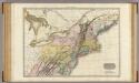
Northern provinces of the United States / drawn & engraved for Thomson's New general atlas, 1817 ; Hewitt Sc. ...
from Parts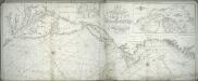
A new chart of America with the harbors of New York, Boston, &c / drawn from the latest authorities by W. Heather, 1799 ; Stephenson sculp.
from Charts and maps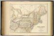
United States ... North Eastern States.
1 : 2851200 Fullarton, A. & Co.
Northern provinces of the United States
United States of America, northern part.
1 : 2100000 Pinkerton, John, 1758-1826
Novi Belgii Novaeque Angliae nec non partis Virginiae tabula / multis in locis emendata per Nicolaum Visscher.
from John H. Levine Collection
Vereinigte Staaten von Nord-Amerika in 6 blattern, bl. 3

Nördlicher Theil der Vereinigten Staaten
Stieler's Hand-Atlas Stieler, Adolf bei Justus Perthes
Novi Belgii Novaeque Angliae nec non partis Virginiae tabula : multis in locis emendata
1 : 2250000 Visscher, Nicolaes, 1649-1702 Ex officina N. Visscher
Novi Belgii Novaeque Angliae nec non partis Virginiae tabula multis in locis emendata
1 : 2000000 a Nicolao Joannis Visschero [S.l.] : [s.n.]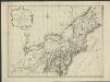
Nieuwe en nauwkeurige kaart van een gedeelte van Noord America, behelzende Nieuw England, New York, Pensylvania, New Jersey, Connecticut, Rhode Island, een stuck van Virginia, Kanda en Halifax, ter opheldering der reizen van den Heer P. Kalm
1 : 2000000 C.J. de Huyser direx. P. Mol geletterdt Te Utrecht : by de boekverkopers J. v. Schoonhoven & Comp. en G. v. d. Brink jz.
United States.
1 : 3380000 Sharpe, J.
Novi Belgii Novaeque Angliae nec non partis Virginiae tabula / multis in locis emendata a Nicolao Joannis Visschero
1 : 2500000 Annotatie: Lit.: The map collectors' circle, no. 24 (1965); Oorspr. uitg.: [Amsterdam : N.J. Visscher, ca. 1655] Visscher, Claes Jansz. [Amsterdam : nunc apud Petr. Schenk Iun.]
New York.
from Whole
Railroad Map Of The Eastern & Middle States.
1 : 380160 Rand McNally and Company
A new map of the most considerable plantations of the English in America / Sutton Nicholls, sculp.
from Parts Sutton Nicholls,


[Côte de York-town à Boston : Marches de l'armée].
from Histoire des troubles de l'Amérique anglaise, ecrite sur les mémoires les plus authentiques ... par François Soulés ...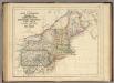
States Of Maine, N. Hampshire, Vermont, Massachusetts, Rhode Island, Connecticut, New York, Pennsylvania, And New Jersey.
1 : 3453120 Rogers, Henry Darwin