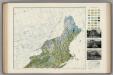
Maps of Nova Scotia

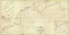
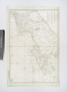
Carte réduite des côtes orientales de l'Amérique septentrionale: contenant celles des provinces de New-York et de la Nouvelle Angleterre, celles de l'Acadie ou Nouvelle Ecosse de l'Île Royale de l'Île St. Jean avec l'intérieur du pays / dressée au Dépôt général des cartes, plans et journaux de la marine, pour le service des vaisseaux du roi, par ordre de M. de Sartine, conseiller d'état, ministre et secrétaire d'état ayant le département de la marine; Petit, sculp.
from Parts M. de Sartine,
Sectional map indicating main automobile roads between Canada and United States
1 : 1900800 Kanada východní National Development Bureau
Carte réduite des côtes orientales de l'Amérique septentrionale: contenant celles des provinces de New-York et de la Nouvelle Angleterre, celles de l'Acadie ou Nouvelle Ecosse, de l'Île Royale de l'Île St. Jean, avec l'intérieur du pays dressée au Dépôt général des cartes, plans et journaux de la marine, pour le service des vaisseaux du roi, par ordre de M. de Sartine, conseiller d'Etat, ministre et secretaire d'Etat ayant le département de la marine / Petit, sculp.
from John H. Levine Collection M. de Sartine,
Carte réduite du Nord des Etat-Unis avec l'intérieur du pays, pour servirà l'intelligence de cette histoire.
from Histoire de la derniere guerre, entre la Grande-Bretagne, et les États-Unis de l'Amérique, la France, l'Espagne et la Hollande, depuis son commencement en 1775, jusqu'a sa fin en 1783 ...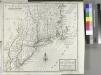
A map of New England, New York, New Jersey and Pensilvania / by H. Moll geographer.
from An historical account of the incorporated Society for the Propagation of the Gospel in Foreign Parts. Containing their foundation, proceedings and the success of their missionaries in the British Colonies, to the year 1728. By David Humphreys.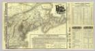
Map Boston & Maine Railroad.
1 : 2192000 Boston and Maine Railroad
Map Boston & Maine Railroad.
1 : 2471040 Boston and Maine Railroad
G. Woolworth Colton's railroad, township & distance map of New England : with adjacent portions of New York, Canada & New Brunswick
1 : 900000 Colton, G. Woolworth (George Woolworth), 1827-1901 G. Woolworth Colton
Map, showing the commercial position of Portland
Map, showing the commercial position of Portland ... and its connection by lines of steamboat and railway with Europe, the British Provinces and the United States. Drawn and engraved for the State of Maine Newspaper. A.C. Morton, Engineer. (Map, showing the Plan for shortening the Transit between New York and London.) J.B. Cummings.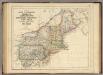
States Of Maine, N. Hampshire, Vermont, Massachusetts, Rhode Island, Connecticut, New York, Pennsylvania, And New Jersey.
1 : 3453120 Rogers, Henry Darwin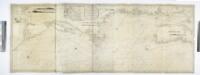
A new chart of the coast of America from Philadelphia to Halifax Harbor / by Wm. Heather, 1809; Stephenson, engraver.
from Whole William Heather,
Map showing the Portland & Rochester railroad and its connections
1 : 900000 G.W. & C.B. Colton & Co G.W. & C.B. Colton & Co.
Tierra nveva.
from Charts and maps
New England and New York.
1 : 3000000 Lloyd, H.H.
New England and New York.
1 : 3000000 Walling, H. F.
United States 4.
1 : 1750000 Arrowsmith, Aaron
Map of railways in the New England states : engraved expressly for Snow's pathfinder railway guide
Geo. K. Snow & Hapgood (Firm) Geo. K. Snow & Hapgood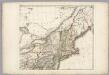
Sheet 2: United States of Nth. America.
1 : 1584000 Tardieu, P.F.
Lower Canada.
1 : 2200000 Arrowsmith, John
Canada.
1 : 4100000 Hughes, William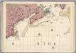
A Map of the British Empire in America. (Sheet 7).
1 : 2000000 Popple, Henry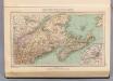
129. Maine, Nova Scotia, New Brunswick, Quebec.
1 : 3000000 Touring club italiano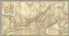
Map of the Provinces of Lower & Upper Canada.
1 : 887040 Wyld, James, 1812-1887
Nova Anglia, Novum Belgium et Virginia

Northern provinces of the United States
Soil Map of the United States, Section 1. Atlas of American Agriculture.
1 : 2500000 Marbut, Curtis F.
Nova Scotia, Cape Britain.
1 : 1900000 Jefferys, Thomas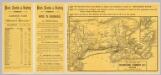
Intl. Steamship Co.'s routes.
1 : 3244000 International Steamship Company
Railway map of routes to the White Mountains
Boardman, Harvey J.H. Bufford's Lith.